New Forest history / New Forest heritage - an introduction and overview
New Forest history need never be dull!
When considering the history of the New Forest, there's always something of interest to see, puzzle over, investigate, and try to understand.
Whether walking, cycling or simply sitting below the spreading branches of aged oak or beech, why not pause to ponder what has gone before; for with increasing knowledge, will come deeper appreciation of this magnificent old hunting ground.
And here to help is a brief account of some of the main headlines from the period of pre-history known as the Bronze Age right the way up until a little after the Second World War.
The Bronze Age
(c. 2000 BC - 650 BC)
Bronze Age barrows
Bronze Age barrows, or burial mounds, provide the earliest surviving, readily visible evidence of man’s occupation of what is now the New Forest. Shaped like upturned pudding-basins, these low, rounded hillocks typically date back to the early-middle Bronze Age around 3,500 years ago, and are usually the last resting places of tribal leaders or other local dignitaries.
Heathland formation
Bronze Age men, though, also left another, perhaps more impressive, legacy, for they were largely responsible for the creation of the heathland we see today. Woodland clearance by these early agriculturalists, on what were already poor soils, then cultivation without any return of nutrients, created ground that became increasingly impoverished. A limited range of acid-tolerant plants and shrubs took hold, and heathland developed.
The Iron Age
(c. 650BC - AD 43)
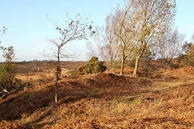
the hill fort interior
Hill forts
Evidence of the presence of Iron Age men is most graphically provided by the remains of a number of their hill forts, one of the most impressive of which sits atop Castle Hill, near Burley. Dating back perhaps 2,500 years, parts of this fort have been destroyed by later development, but a clearly visible eroded bank - the remains of a once substantial defensive rampart - and now part-filled external ditch remain.
Other forts were located at Buckland and Ampress, both near Lymington; Exbury, near the mouth of the Beaulieu River; Malwood, near Minstead; Tatchbury, not far from Calmore; and overlooking the Avon valley north-east of Fordingbridge.
Other earthworks
On a somewhat smaller scale, Castle Piece, hidden deep amongst the trees in Roe Inclosure, is a broadly circular enclosure of around 2 hectares (almost 5 acres) surrounded by a large, flattened bank with, in places, an adjacent external ditch. Other earthworks, usually considered to be of Iron Age origin, include a relatively small circular enclosure to the north of Matley Wood; whilst at Crockford, south-west of Beaulieu, an Iron Age settlement site is visible within a surrounding, wasted earthen bank with shallow external ditch.
Roman occupation
(AD 43 - early 5th century)
In Hampshire, impressive evidence of this period can be found, for example, at Silchester and Rockbourne (town and villa sites, respectively), although significant Roman presence in the New Forest is less readily demonstrated.
However, the remains of Romano-British potteries, in use between the 3rd and early 5th centuries, lie within Islands Thorns Inclosure and other nearby woodlands; a suspected Roman estate boundary can be found close to the site of Beaulieu Airfield; the likely line of a Roman road is visible on the edge of Churchplace Inclosure, near Ashurst; and a section of Roman road survives to the east of Pitts Wood Inclosure.
The Norman invasion and its aftermath
(1066 - 1154)
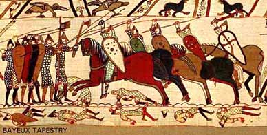
depicting the Battle of Hastings
(Image copyright: Dan Koehl)
Invasion and establishment of a new aristocracy
Descended from a raiding band of Scandinavian Norsemen who settled in northern France during the 10th century, the Normans changed the shape of English history following what has become known as the Norman Conquest.
In 1066, during the Battle of Hastings, Duke William II of Normandy (later William the Conqueror, William 1st of England) famously defeated his cousin, Harold Godwinson, King Harold II, to seize the disputed English throne following the death earlier that year of Edward the Confessor. (The Bayeux Tapestry, probably produced in England in the 1070s, depicts in graphic detail events leading up to the invasion and scenes from the Battle of Hastings).
The south of England was quickly subjugated and the north followed a little later. Landed estates were largely confiscated and handed over to invading Norman noblemen, men loyal to William, during a wholesale, extremely violent where necessary, introduction of a new aristocracy.
Royal forests and the creation of the New Forest
Extensive areas of land were set aside as Royal hunting forests, in part to satisfy William’s enthusiasm for hunting, but also to provide food on the hoof for the king and his followers during their travels around the kingdom.
The New Forest, or Nova Foresta, as it was known, was created in around 1079 as the first of these new hunting grounds and a harsh regime of Forest Law imposed, designed to offer special protection to the deer - the quarry - and the vegetation that provided them with food and shelter. Special courts administered justice and harsh penalties were imposed on those found to have contravened the new laws.
(Royal Forests reached their largest extent during the reign of Henry II (1154-1189), and in the 13th century covered around 1/5 of the country. By the mid-14th century, however, decline had set in and by the 15th century many had fallen out of use - much of the land was progressively sold. The New Forest was not unique, then, as a hunting ground for royalty and the aristocracy, but it is one of the few Forests to retain elements of its original character into the modern age).
Domesday Book
The Domesday Book provides the first mention of Nova Foresta and a considerable amount of detail about land holdings in the area. Commissioned as an extensive survey of land and resources in much of England and parts of Wales, its purpose was to establish and record the value and extent of land and assets before the Conquest, after the Conquest and at the time of the survey, and the identity of relevant landowners. The information was gathered with great speed during 1086 and provided an effective overview of William’s new lands as well as forming the basis for an assessment of tax that could be raised.
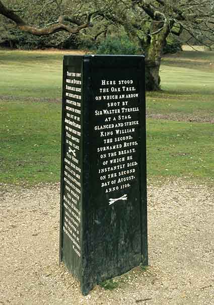
The succession
Upon William’s death in 1087, his eldest son, Robert, was left the lands of Normandy whilst the second surviving son, another William, was given custody of England. Also known as William Rufus, this second son was slain in the New Forest whilst out hunting – the Rufus Stone commemorates the event. (The Normans ruled through often troubled times until 1154).
Reminders of Norman rule
The modern day Verderers’ Court was originally constituted to deal with those accused of breaking Forest Law, whilst reminders of the old hunting forest can still be found in the landscape. The Park Pale, on the outskirts of Lyndhurst, for example, is an impressive, meandering earthen bank and ditch that once encircled what became known as Lyndhurst Old Park, a medieval deer park dating back to at least the 13th century.
Similarly, Bishop’s Dyke, another earthen bank and ditch, is thought to have originally enclosed a deer park, although by 1244 this park was in use as the medieval equivalent of a cattle farm.
The structure of Boldre parish church can be traced back to the 11th century, but Brockenhurst is the only village within the New Forest perambulation for which a church was mentioned in the Domesday survey (along here with 6 smallholders and 4 slaves with 2½ ploughs; and woodland at 20 pigs).
Medieval keepers’ lodges
Again recalling early New Forest use and management, the remains of a number of medieval earthworks associated with Royal Hunting Lodges or Keeper’s Lodges can still be found hidden away in the landscape. Dating from the 14th or 15th century, examples include Studley Castle, within Islands Thorns Inclosure; Church Place within Churchplace Inclosure; another Church Place, this at Denny; the Churchyard, Sloden; and at Queen Bower, near Brockenhurst.
(Despite the ‘church’ place names, there is now no suggestion that religious houses once existed on these sites, although in former times, this association was wrongly assigned to a number of unexplained earthworks in the mistaken belief that William the Conqueror destroyed whole villages, including their churches, to make way for his new hunting ground).
Royal connections
William the Conqueror no doubt hunted in his New Forest, his son William Rufus certainly did and it’s likely that other medieval kings did, too – a lodge at Bolderwood included a great chamber for ‘the King’s comfort’, and New Lodge – thought to have been on the site of New Park, Brockenhurst – also had accommodation for royalty.
Queens Meadow, Queen Meadow Leys and Queen Bower, all a little to the north west of Brockenhurst, also recall the visits of royalty, for repairs to a mill with accommodation for the Queen, situated close to nearby Bolderford Bridge, were recorded in 1310.

Then in December 1648, King Charles 1 was imprisoned in Hurst Castle before transfer to Windsor Castle and onwards for trial for treason and eventual execution. His son King Charles II in the more peaceful times after the Civil War was also associated with the New Forest for he was responsible in 1670 for extending New Park, Brockenhurst, ‘for the preservation of our red deer, newly come out of France.’
And finally, the mid-18th century official residence of Her Royal Highness Princess Sophia of Gloucester, whose father, the Duke of Gloucester, was Lord Warden of the New Forest, was within what is now Ironshill Inclosure; whilst King George III visited Cuffnells and Northerwood House, both near Lyndhurst.
Times change: the New Forest as a source of timber
Introduction
Enthusiasm for the hunt eventually subsided, so-much-so that by 1428 the deer park at Lyndhurst was reported to be poorly maintained, although disparking does not seem to have occurred until the 16th century. New Park, Brockenhurst, however, continued in use and, as has already been mentioned, was extended in 1670 by Charles II. Furthermore, three stag parks, considered to be of 17th century origin, are shown on Richardson, King, Driver and Driver’s late 18th century map of the New Forest – in what is now Highland Water Inclosure, at Denny and close to Rhinefield House.
Early Acts of Parliament
The New Forest was, however, to become of increasing importance to the nation for another reason: as a provider of timber for the Royal Navy. Early legislation to authorise the enclosure of woodland to protect regenerating and young trees from the depredations of deer and commoners’ stock dates back to 1483, whilst subsequently, many years of neglect, heavy grazing and browsing pressure, extensive use of the woodlands by charcoal burners and the widespread pollarding large trees, resulted in severe shortages of timber suitable for ship building. Something had to be done, and so it was, in the form of a number of Acts of Parliament designed to provide conditions suitable for timber growth.
(Acts of Parliament were necessary as otherwise the erection of fences was forbidden - the deer were still to have freedom to roam and commoners’ animals were entitled to unhindered access to grazing and browse).
Further Acts of Parliament: 1698, 1808 and 1851
The 1698 Act for the Increase and Preservation of Timber in the New Forest and subsequent Acts of Parliament of 1808 and 1851 included authorisation to create inclosures within which trees could be grown and from which commoners' stock and deer were, at least initially, excluded, provisions that were to have a dramatic impact on the New Forest landscape as heaths, lawns, scattered hollies and ancient woodlands were lost to timber plantations.
The 1851 Act, more properly known as the 1851 Deer Removal Act, also included provision for the compilation of a register of common rights, allowed for the extensive use of conifers in the new inclosures and also provided for removal of all the deer, a measure that led to the extermination of virtually all those present – they were considered a threat to forestry interests, competed with the commoners’ stock for foodstuffs and were liable to cause a nuisance by wandering onto adjacent private land.
Protection for commoning and a growing emphasis on amenity considerations
The 1877 New Forest Act
The 1851 Act was, however, deeply unpopular, particularly with the commoners, who suspected that plans were afoot to reduce or eliminate the value of their common rights. Disafforestation was proposed but rejected before in 1875 a select committee found in favour of both commoning and amenity issues, saving the New Forest as we know it and leading to the 1877 New Forest Act, legislation that is often referred to as ‘the Commoners’ Charter’.
Amongst other provisions, this Act halted the creation of further woodland inclosures, confirmed the extent of the area that could be fenced at any one time, changed the role of the Verderers’ Court from the age-old but outdated concern with upholding Forest Law to looking after the interests of the commoners and, as increasing numbers of visitors arrived to enjoy the scenery, recognised the growing amenity value of the New Forest by providing protection for the old, ‘ancient ornamental woods’.
The 1949 New Forest Act
Further Acts of Parliament were almost inevitably to follow, the next in 1949 which included provision for the creation of a small number of additional woodland inclosures, but only with the agreement of the Verderers and in return for compensation payments to reflect the land lost to grazing.
The New Forest: its military role
A further strand to the New Forest story was added in the 19th and 20th centuries when the area was used intermittently, but extensively, for military purposes.
During the first half of the 19th century, for example, Bramshaw Telegraph was the site of an optical shutter signal station, one in a line that linked Plymouth with the Admiralty in London, primarily during the Napoleonic Wars. And from the late 1850s until around 1908, local Rifle Volunteer Corps, initially established to combat what was perceived as a threat from the French, undertook shooting practice using New Forest rifle ranges.
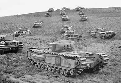
manoeuvre near Brockenhurst on 13 August 1942
(Image courtesy of the Imperial War Museum)
Military manoeuvres and other operations were also completed in the New Forest in preparation for action during the Boer War and both the First and Second World Wars. For example, extensive First World War use was made of the land between Lyndhurst and Matley Wood - Transit Camps were established for men en-route to the front, a Bombing School was in operation and War Dog training was undertaken.
New Forest timber, too, significantly contributed to the First World War effort – the Portuguese Fireplace recalls the timber harvesting contribution made by overseas woodsmen; whilst the Forest at this time also played a significant part in the rapidly developing wartime use of aircraft - pilot training, for example, was undertaken using an airfield at East Boldre and a Royal Naval Air Station was established at Calshot
Timber was again extensively taken to support the Second World War effort and, to help alleviate food shortages, a numbers of areas of open Forest land were ploughed, cropped and subsequently reseeded. Other major contributions to the Second World War effort included the use of airfields set up near Beaulieu, at Holmsley, Stoney Cross and elsewhere; the creation of an experimental bombing range at Ashley Walk; the use of land at nearby Millersford for static trials of explosive devices undertaken by the Armaments Research Department; and Special Operations Executive (SOE) (espionage, sabotage and reconnaissance) training undertaken on the Beaulieu estate.
Elsewhere in the New Forest, during both First and second World Wars, hotels and country houses – such as the Balmer Lawn Hotel, Northerwood House, and Cuffnells – were requisitioned for wartime use, field hospitals were established and troops located in the area whilst awaiting action overseas.
And during the First and Second World Wars, the New Forest was home for varying periods of time to influxes of Americans, Australians, Canadians, Indians, New Zealanders and men from other nations engaged with Britain in wartime efforts - the Canadian Memorial at Bolderwood commemorates the contribution of some of the Canadians - whilst a prisoner of war camp at Setley Plain, near Brockenhurst, initially hosted Italian prisoners and later German prisoners.
Local history
And of course, the New Forest has a rich local, perhaps more parochial history to interest those curious about the past. Village histories are fascinating in their own right; the development of turnpike roads, the coming of the railways and the advent of the motor car tell of relatively recent transport revolutions and their impact on the villages; and stories through the ages tell of wealthy landowners and their New Forest homes.
Industry, too, has had a long presence in the area, ranging from the Romano-British potters of old, charcoal burners who plied their trade in the woods, 16th century producers of saltpetre at Ashurst and the 18th century shipbuilders of Buckler’s Hard, through to the relatively more recent manufacturers of gunpowder at Eyeworth and the use of locally grown alder wood in the production of wartime gas masks.
Then from as early as the 19th century, attempts have been made to improve the extent and quality of grazing land and that used for forestry by cutting drainage channels, laying drains and straightening and deepening streams, many of which have left their mark on this ancient landscape.
And finally
Imagine, then, the processions of characters across this landscape. Enjoy learning about their past presence, and appreciate the New Forest for what it is: a magnificent, historically rich area of international importance to which all are privileged to have access.Find out more about New Forest heritage
Quick linksMore links
Search this site
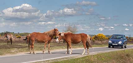
Sadly, 58 animals were killed - 35 ponies, 13 cows, 8 donkeys and 2 sheep, whilst a further 32 were injured - 3 pigs, 9 donkeys, 11 cows and 9 ponies.
(Forty-three accidents occurred in daylight, 15 at twilight and 101 in the dark. Twenty-seven accidents were not reported by the driver involved).
Here's just one horrific example - Three donkeys killed in collision with van at notorious New Forest blackspot (Advertiser and Times)
Sika deer continue to engage in rutting behaviour, and will do so until December.
Pigs seek out the remains of the acorn crop.
Beech leaves are transformed into a magnificent mosaic of glorious reds and golds. Other deciduous trees, too, take on an autumnal cloak before their leaves fall.
Dragonflies can occasionally be seen on the wing on bright days early in the month.
December
Foxglove leaves survive the winter at ground level, and offer the prospect of colourful summer blooms to come.
Redwings and fieldfares, autumn and winter visitors, gorge on haws and holly berries.
Great grey shrikes and hen harriers hunt over the heaths and other open spaces.
Honeysuckle by the end of the month often shows welcome signs of new growth.
