

Bishop’s Dyke
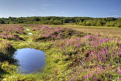
Close to Beaulieu Road station and shown on the map as Bishop’s Dyke, this earthen bank and ditch winds a 7.25 kilometre (4½ mile) serpentine course, and encloses around 202 hectares (500 acres) of low-lying, boggy ground.
Up to 4 metres (13 feet) wide and 1 metre (3 feet) high, it is also known as the Bishop’s Ditch and the enclosed land, the Bishop of Winchester’s Purlieu - a purlieu is land once within the jurisdiction of the Forest, but no longer so.
John Wise, writing in the middle years of the 19th century, said that the area belonged to Winchester College, and noted that: ‘The New Forest peasant will tell that this was a grant of land as much as the Bishop of Winchester could in a day crawl round on his hands and knees.’
Then Heywood Sumner, writing 60 years after Wise, stated that in 1284 AD, John de Pontoise, Bishop of Winchester, obtained the grant of Bishop’s Ditch from Edward 1. But Sumner went on to dismiss the peasant’s theory mentioned by Wise, saying that: ‘The legend – which occurs elsewhere - seems to express country humour, attributing a fantastic origin to an unusual earthwork of which nothing is known.’
It has also been suggested that the bank enclosed a huge decoy pond, or alternatively, despite the current boggy nature of much of the ground, that it may have enclosed a medieval deer park.
Recent research by local historian Richard Reeves has, however, revealed that the land within Bishop's Dyke, known then as Penimore, was granted in 1213 to Peter des Roches, Bishop of Winchester. Authority to enclose it with a deer-proof bank and ditch - the one seen today - was given in 1216. Initially, the land was probably used as a deer park - the Bishop was known to be an enthusiast of the chase - but by 1244 it was seemingly in use as the medieval equivalent of a cattle farm.
(Penny Moor on modern maps is shown beside the railway that now intersects the Purlieu).
The land was returned to the Crown in 1944.
References:
The New Forest: Its History and Scenery: John R. Wise.
A Guide to the New Forest: Heywood Sumner
Proceedings of the Hampshire Field Club & Archaeological Society, Volume 54 – The Earthwork Remains of Enclosure in the New Forest: Nicola Smith
More links
Other related links
Search this site
Sadly, 58 animals were killed - 35 ponies, 13 cows, 8 donkeys and 2 sheep, whilst a further 32 were injured - 3 pigs, 9 donkeys, 11 cows and 9 ponies.
(Forty-three accidents occurred in daylight, 15 at twilight and 101 in the dark. Twenty-seven accidents were not reported by the driver involved).
Here's just one horrific example - Three donkeys killed in collision with van at notorious New Forest blackspot (Advertiser and Times)