Burley history - an introduction
The early days
Burley's history can be traced back to the Bronze Age, to people who occupied the area 3,500 years, or so, ago, and left impressive earthen burial chambers as signs of their passing.
Marked on Ordnance Survey maps as tumuli, or tumulus, these Bronze Age barrows continue to adorn the Burley landscape, often now as low, rather wasted, relatively inconspicuous mounds.
Burley also boasts an Iron Age hillfort, one of the few to be found in the New Forest. Located on Castle Hill, Burley (A), the fort dates back around 2,500 years. In places, a substantial bank - the rampart - is visible, together with accompanying, silted ditch.
From the fort's well-placed position atop the ridge overlooking Vales Moor, Strodgemoor Bottom and Cranes Moor; distant views towards the Avon valley and Poole Harbour can be enjoyed. Access to the fort is via Castle Hill Lane, a narrow track leading south from the junction of the Burley, Crow and Picket Post roads.
Burley was not specifically mentioned in the Domesday survey of 1086, although an entry for nearby Ringwood is thought to refer to what was to become Burley. Ringwood then was stated to comprise 6 hides, with a further 4 in the Forest in which 'Dwelt 14 villagers and 6 smallholders with 7 ploughs; a mill at 30d; and woodland at 189 pigs from pasturage'.
The origin of the village name is a matter of debate. Some favour derivation from the hill-fort: burh - a fortified place, and leah - a wood / clearing. Others prefer the Ringwood connection, and a meaning that comes from 'clearing / wood of the borough or town'.
Burley Lodge and Burley Manor
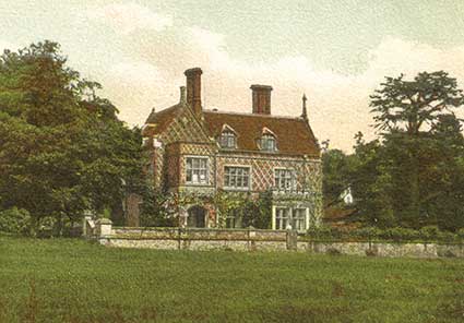
Burley Lodge, situated 3.5 kilometres (2 miles) to the north-east of the village centre, outside the area shown on the map above, boasts documentary evidence dating back to 1490; whilst Burley Manor (C) was established as a place of some importance almost three hundred years before this - Roger de Burley in 1212 was recorded first as Lord of the Manor, followed in 1251 by Richard de Burley and in 1316 by a second Richard de Burley.
From 1716, successive Dukes of Bolton held Burley Bailiwick, and lived at Burley Lodge until 1809. Bolton's Bench, on the outskirts of Lyndhurst, bears their name; whilst at the request of the 3rd Duke, a road was constructed from Lyndhurst, leading towards Burley - the route still shows on modern maps as the Cut Walk. (Burley Lodge is not open to the public).
Burley on old maps
In the late 18th century, mapmakers Richardson, King and Driver illustrated Burley Manor's local dominance, showing occupation of its current extensive central position, and also ownership of a number of substantial outlying parcels of land.
The present Manor building, though, was not constructed until 1852, and has been added to and considerably altered since. It became a hotel in 1933, and continues as such today, although it was requisitioned for military use by the War Office during the Second World War.
The Richardson, King and Driver map was produced in 1789, but does not show Burley Chapel (D), which was built in the same year, largely at the instigation of Thomas Eyre, who administered the Burley Manor Estate from 1780 until his death in 1829. The chapel was completely rebuilt in 1842-43, but services are now no longer held there, and the property is in private ownership.
Both chapel and graveyard can, however, be seen from the roadside ½ kilometre (a third of a mile) to the north-east of Burley Parish Church (E). Dedicated to St John the Baptist, the parish church was consecrated in 1839, although later additions and alterations took place in 1886/7, and again during the 20th century.
Also prominent on the old map is an inverted 'Y' shape that indicates the routes followed by the old road system. The eastern fork is now known as Ringwood Road, with towards its southern end, today's village centre. The western fork, Honey Lane (F), remains as a gravel / dirt track linking Pound Lane to Ringwood Road.
For part of its length, the track becomes a deep hollow-way with high sided, moss-clad banks and overhanging branches that, when in leaf, form a somewhat darkened tunnel, within which it is always tempting to imagine travellers of days-gone-by passing along this same route.
On the old Burley map, incroachments - land taken from the New Forest without authority - are clearly shown, particularly in the vicinity of Mill Lawn and around what then was shown as Bistern Closes. The adjoining hamlet of Burley Street is not named, although dwellings and incroachments are again marked. An earlier 17th century record does, however, refer to the Ringwood road as a 'Highway leading to Burley Streete'.
Thomas Eyre's milestones and other commemorative stones
More of Thomas Eyre's handiwork can be seen around Burley, for he was responsible for the placement of a number of mile and other stones that still remain in position. One, opposite the Manor entrance (G), notes: 'To Ringwood 5, Christchurch 8, Lymington 9 miles', above the names of 'Thos Eyre and H. Bromfield, Surveyors', and the date 1802.
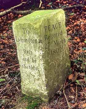
Another stone (H), on the bank opposite the 17th century Queen's Head pub, includes the inscription 'Rest and be thankful', and 'Peace Restored 27th March 1802', the date commemorating the Peace of Amiens, a treaty that brought a temporary cessation of hostilities between Britain and France during the Napoleonic Wars.
(This stone is sometimes known as the Bread Stone or Gift Stone for by direction of Thomas Eyre's will, his charity of shoes, clothes and blankets was 'to be distributed annually by the overseers upon the Stone near the Queen's Head where it is inscribed 'Rest and be thankful' on the 23rd day of October, or if a Sunday, the day after, to 12 poor women and girls not less than 12 years of age').
Burley Mill
Burley Mill ceased operation in around 1820, and was described as 'an over-shot water corn mill'. It was located at Mill Lawn (B), close to where the present road crosses Mill Lawn Brook. All that remains is the grist house in the grounds of Mill Cottage, whilst the waterfall in the garden of Waterfall Cottage marks the site of the mill wheel.
Castleman's Corkscrew
And finally, reference to Burley's history would be incomplete without mention of Castleman's Corkscrew, a mid-19th century railway line that passed a little to the south of the village (but just outside the area covered by the map above). Named after Charles Castleman, a Wimborne solicitor, and the serpentine course followed through the countryside, the line stretched from Southampton to Dorchester. The section to the south of the village is now open for recreation, for walkers, cyclists and others to enjoy.
Find out more about Burley's fascinating history:
References:
Records of Burley - aspects of a New Forest village: F. Hardcastle B.E.M.
Hampshire Treasures
Domesday Book: Edited by Julian Munby
Hampshire Place Names: Richard Coates
St. John the Baptist Church
The History of War
More links
Other related links
Search this site
Sadly, 58 animals were killed - 35 ponies, 13 cows, 8 donkeys and 2 sheep, whilst a further 32 were injured - 3 pigs, 9 donkeys, 11 cows and 9 ponies.
(Forty-three accidents occurred in daylight, 15 at twilight and 101 in the dark. Twenty-seven accidents were not reported by the driver involved).
Here's just one horrific example - Three donkeys killed in collision with van at notorious New Forest blackspot (Advertiser and Times)
Silver-washed fritillary butterflies brighten many woodland rides.
Bird song subsides as the annual moult begins - old worn feathers are cast off and new replacements grown.
Wild gladiolus plants bloom. (In the UK, this species is found only in the New Forest).
Dragonflies and Damselflies take to the wing in ever increasing numbers.
August
Heather blossom produces huge swathes of heathland colour, adding to the pinks and purples of earlier flowering cross-leaved heath and bell heather.
Fallow, red and sika deer antlers, when fully grown, are cleaned of velvet in preparation for the autumn rut.
New Forest pony drifts - the annual round-ups - begin.
Marsh gentian blooms add splashes of blue to some of the wetter heathlands.