

Castle Hill, Burley - an Iron Age hillfort with spectacular views
(Castle Hill can be explored during this 3½ mile Burley walk).
Castle Hill, Burley, is located at the northern end of a quite broad, gravel ridge a little to the south-west of Burley Street, not far from the Picket Post / Crow fork in the minor road from Burley - at map reference SU198039, shown with an 'X' on the accompanying map. (Ringwood is the nearest town).
Castle Hill is not particularly well-known but arguably is should be, for the village name 'Burley' may in part derive from the Old English word 'burh', which indicates a fortified place.
(1) Introduction
The remains of the fortifications at Castle Hill, Burley, stand on a rounded hillock, and were described on a stone placed in 1823 at nearby Black Bush by Thomas Eyre, House Steward and Bailiff to Burley Manor. He regarded them as ' ... the remains of a camp or castle either of the Ancient Britons, Romans or Saxons'. The stone, incidentally, is now nowhere to be seen, certainly not from publically accessible land.
By 1871, the Ordnance Survey 6" to the mile map of the area showed the remains as a 'Supposed Intrenchment' - an entrenched fortification, a position protected by trenches - and on the 1907 map, we simply see the word 'Earthwork' accompanying the castle. On modern maps, Castle Hill is marked as a Fort.
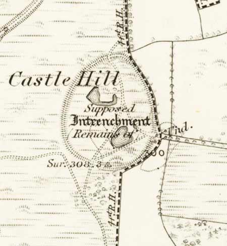
(The earthworks appear much the same on modern maps, but reflecting the uncertainty associated with the site, the Victorian map makers added the notation 'Supposed Intrenchment' - an 'entrenched fortification, a position protected by trenches').
Then in 1923, New Forest resident and respected antiquarian Heywood Sumner described the earthworks on Castle Hill as 'a pre-Roman camp of defence at the northern end of Burley Beacon ridge'.
And local historian Félicité Hardcastle B.E.M. in Records of Burley (1950) noted that the remains were of Bronze Age or Iron Age origin, and 'in any case certainly pre-Roman'.
All in a way were quite right, for Castle Hill is now recognised as the site of a univallate Iron Age hillfort, a fort having just a single encircling ditch and rampart.
Heywood Sumner was also correct when he went on to mention fine views over the Avon valley, Dorset and Wiltshire, for that is absolutely the case as the land drops steeply away from the hill-top to the north-west and west before giving way to the low-lying heaths and bogs of Little Castle Common, Broad Bottom, Vales Moor, Strodgemoor Bottom, Church Moor and Cranes Moor. Trees now, however, obscure whatever views there originally were to the north, east and south-east.
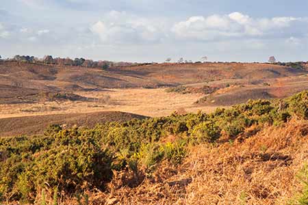
This hill-top location made was an ideal place to build a fort, providing unimpeded sight lines that would make it difficult for aggressors to approach unseen. Equally, the hillfort would have been impressively visible for miles around, a statement of territory, power and capability sufficient to make all but the bravest, most ambitious potential attackers think again.
(2) Castle Hill - the hillfort
The hillfort's single rampart and outer ditch enclose a broadly oval area of around 2 hectares (5 acres), whilst the hill at this point is 94 metres (308 feet) above sea level.
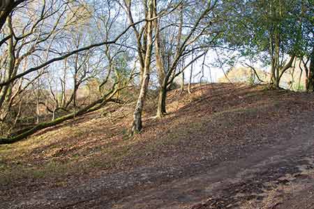
The ghostly remains of the ramparts, although inevitably much eroded by the ravages of time and weather, are for the most part in reasonable condition and survive around most of the circumference of the fort, raised 0.6 metres (2 feet) to 2 metres (6½ feet) above the interior and 2.5 metres (8 feet) to 4.5 metres (15 feet) above the surrounding somewhat in-filled ditch and low counterscarp bank.
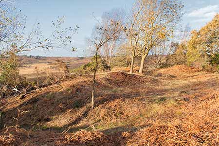
Part of the central area is now quite open but elsewhere mature trees, bracken and other vegetation have taken hold, whilst 19th century, or earlier, gravel extraction has caused inevitable damage to a significant part of the interior (and spilled over at the northern end, by the fort's entrance), creating in the process a number of pits, some of which are now marshy and / or flooded with water.
Castle Hill Lane, a pronounced ridge-top gravel road running from Pound Lane, Burley, cuts through the earthwork, passing at the northern end through a probable original entrance to the fort and through a later southern entrance, whilst an entrance on the eastern side, close to a relatively modern electricity sub-station and newly built garden wall, may or may not be original.
Historic England describe Castle Hill as the site of a 'slight univallate hillfort' and note that these are 'generally between 1 hectare (2½)acres and 10 hectares (25) acres in size, situated on or close to hilltops and defined by a single line of earthworks, the scale of which is relatively small'. They are relatively rare nationally with around 150 examples recorded and typically date from between the Late Bronze Age and Early Iron Age (eighth - fifth centuries BC).
The majority of such forts were used for 150 to 200 years prior to their abandonment or reconstruction. They have been interpreted as stock enclosures, redistribution centres, places of refuge and permanent settlements, although which of these apply to Castle Hill is unknown.
Castle Hill has not been subject to formal archaeological excavation, and no records of artefacts, if any, discovered by the gravel extractors have been found. The fort is considered by Historic England to have survived comparatively well, despite the efforts of the gravel diggers, and is viewed as being of national importance.
It is scheduled under the Ancient Monuments and Archaeological Areas Act 1979, as amended.
References:
Hampshire Place Names: Richard Coates
A Guide to the New Forest: Heywood Sumner
Records of Burley: Félicité Hardcastle B.E.M.
Proceedings of the Hampshire Field Club & Archaeological Society, Volume 54 – The Earthwork Remains of Enclosure in the New Forest: Nicola Smith
Historic England
Hillforts of the New Forest National Park: Chris Read (New Forest History and Archaeology Group)
Quick links
More links
Search this site