

A walk to Castle Hill, Iron Age hill fort - Burley
Also featuring - Burbush, Castle Hill Lane, Honey Lane and Slap Bottom
Overview
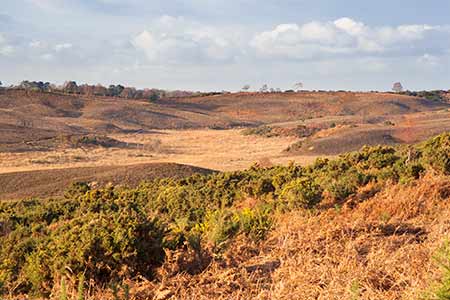
This pleasant walk offers impressive views over heathlands and wetlands in the west of the New Forest, and takes in the Castle Hill, Iron Age hill fort.
*** Find out lots more about the Castle Hill, Iron Age hill fort. ***
The route features much level ground although there are a number of moderate gradients. A relatively short section can be wet underfoot, although a diversion to avoid the wet ground is available.
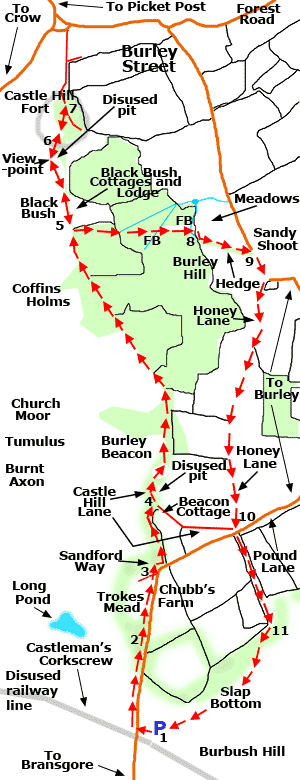
The walk starts in the Burbush car park, located beside Pound Lane - a minor road running from Burley to Bransgore - and the now disused route of Castleman's Corkscrew, a mid-19th century railway line that last saw trains in 1964.
*** Find out lots more about Castleman's Corkscrew. ***
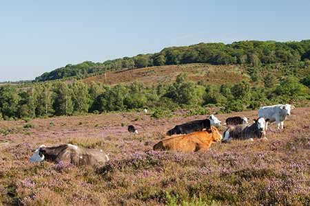
Heathland is encountered early in the walk, alongside the minor road, before the route heads up onto a ridgeway track through what is essentially ancient, unenclosed woodland overlooking low-lying land to the west.
The Castle Hill, Iron Age hill fort is reached and the outward route is then retraced for a short distance before a public footpath is followed through privately owned woodland and across farmland.
Honey Lane, an aged trackway with a name that dates from at least the first years of the 18th century, leads back to the Burley - Bransgore road. (Although not named as such, Honey Lane is clearly shown on Richardson, King and Drivers' late 18th / early 19th century map of the area, and as a trackway, it almost certainly pre-dates the 18th century by some considerable margin. A historical connection with bee-keeping is probably a reasonable assumption).
The route is completed by a walk through more ancient, unenclosed woodland and finally back across open heathland.
Elsewhere along the way
Burbush at the start of the walk was considered by local historian Miss F. Hardcastle B.E.M., writing in 1950, to be a site 'of considerable antiquity and a very old place name', meaning Bushy Hill. Miss Hardcastle also went on to note of Chubbs Farm, passed early in the walk route: 'Chubbs Farm and Burbush have for many years been one property, but in the 18th century these fields were in different ownerships, and of them the Chubb family farmed about 36 acres. The first man of that name, Abell Chubb, appears in the Ringwood Burial Register in 1696'.
The site of Burley Beacon is passed shortly after Castle Hill Lane is joined. The beacon is shown on Richardson, King and Drivers' map, and continues to be shown on modern Ordnance Survey maps. It is also commemorated in the nearby house name 'Beacon Cottage'. The first mention of the beacon found by Miss Hardcastle was in a 1681 Perambulation of the New Forest. It couldn't, however, be traced in old lists of south Hampshire beacons and was therefore assumed to have been of only minor importance.
Burnt Axon, Church Moor and Coffins Holms are located on the open ground a little to the west of the walk route, and again we can look to Miss Hardcastle's local knowledge to help us understand the meaning of these seemingly strange names.
Firstly, Axon apparently derives from ash, as in the tree; whilst burnt, it is suggested, refers to land reclaimed by burning, so Burnt Axon probably means 'ash woodland reclaimed by burning'.
Church Moor is a name found here and in other parts of the New Forest. Miss Hardcastle recounts that: 'Heywood Sumner has found barrows near each such name and deduces an erroneous connection between graveyards and burial mounds'. Certainly there was neither a church nor a graveyard at this Church Moor, and there is a Bronze Age barrow, shown on modern maps as a Tumulus.
Coffins Holms is an oak and holly wood on the open Forest immediately south-south-east of Black Bush. Holm, like Hat, is used locally to refer to quite small, roughly circular areas of woodland, often on open ground and usually with mature hollies present. And as for Coffin, this is said to derive from the family of the same name who were present in Burley from before 1664.
And finally, whilst considering local names, Pound Lane was predictably the site of one, or maybe more than one, of Burley's village pounds, places where stray animals could be impounded until collected by their owners; and where animals driven from the open Forest could be held. Burley Pound is referred to in a document dated 1685 (Miss Hardcastle again), whilst in the 19th century, and maybe earlier, much of the lane was gated at both ends so that animals could be impounded along the gated length.
3½ miles (A little over 5.5 kilometres).
Start:
Burbush car park, beside Pound Lane, a minor road running from Burley to Bransgore - the car park is a little over one mile (1.6 kilometres) from Burley village centre.
Terrain:
Largely on level, firm ground but with some moderate gradients and, particularly in winter and after heavy rain, some potentially wet ground.
Refreshments:
There are a number of pubs and tea rooms in nearby Burley.
New Forest Tour bus route:
Yes - summer only, through Burley.
Parking
Park in the Burbush car park, a little over one mile (1.6 kilometres) from Burley village centre.
Walking from Burley village centre
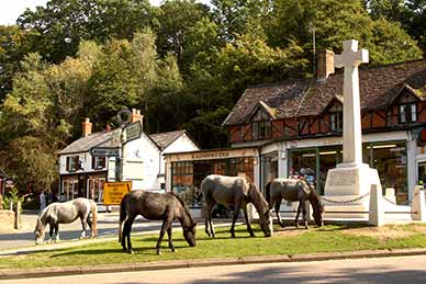
Leave Burley village by walking along Pound Lane - Pound Lane starts beside the War Memorial Cross, in the centre of the village. Follow Pound Lane for a little over ½ mile (1 kilometre) and reach on the right a junction of vehicle-width tracks where Honey Lane and Castle Hill Lane meet Pound Lane - at point 10 on the route map.
Ignore Honey Lane, which is immediately on the right, and instead follow Castle Hill Lane towards Beacon Cottage. After around 300 metres, pass Beacon Cottage on the left and follow the walk route from the beginning of section 4.
Towards the end of the walk, to return to Burley village centre - after following Honey Lane back to Pound Lane, turn left at point 10 and follow Pound Lane back to the village.
Walk route directions
1. Leave the Burbush car park at its main entrance (cycle track post 157), cross the Burley to Bransgore road and turn right. Continue along the heathland edge, parallel to the road, and later beside a stretch of woodland.
Pass the Burley village sign and immediately after, cross a narrow stream / drainage channel which is often dry to the left of the road and choked with vegetation to the right.
2. Continue parallel to the road for a short distance and pass 30 mph speed limit signs close to the main entrance to Trokes Mead on the left, and Springmoor Farm and Chubb's Farm on the right.
Please note, there is no footpath for around the next 200 metres, so great care is needed.
Follow along the edge of the road for a relatively short distance and pass a gravel track on the left, beside an alternative entrance to Trokes Mead - this is located at the start of a quite pronounced right-hand bend in the road.
3. Immediately after this gravel track, pass on the left a cottage called Sandford Way and immediately after that, turn left along what initially is a quite wide gravel track running beside the garden of Sandford Way on the left; and a hedgerow, with paddock beyond, on the right.
The gravel track quickly becomes a footpath running quite close to, and broadly parallel with, a fence-line bordering private land on the right. Follow this path for around 200 metres through open woodland whilst enjoying tantalising views over the heaths and bogs to the left.
Eventually reach a junction of tracks beside Beacon Cottage on the right, and turn left here along Castle Hill Lane.
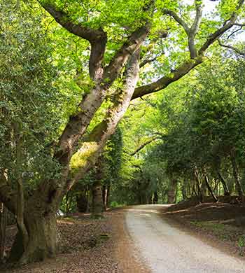
4. Follow Castle Hill Lane - a quite wide gravel track - as it goes a little uphill and bends round to the right, bordered by attractive ancient and ornamental woodland within which on the right is evidence of an extensive old gravel or clay pit - the first of a number passed on the way to the hill fort.
Follow the wide, undulating, ridge-top track for a little over ½ mile (1 kilometre) whilst along the way enjoying further intermittent heathland views through the trees to the left.
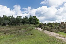
5. Pass Black Bush Cottages and Lodge on the right, and Black Bush on the left, and notice after a relatively short distance a quite small open, grassy area invaded by bracken on the left that affords extensive, panoramic views over the adjacent low-lying heath to the west.
6. Shortly after, follow the gravel track as it passes through the still-impressive ditch and ramparts of the Castle Hill, Iron Age hill fort and reaches on the left another grassy open area which is part of the hill fort interior.
7. Explore the hill fort and its ditch and ramparts, or simply enjoy the views from the hill-top over what here is an unusual low-lying landscape from which erupt numerous irregularly spaced, quite large heathland hillocks.
Retrace the route back to Black Bush at the start of section 5 and almost immediately after passing the entrance to Black Bush Cottages and Lodge, go over a stile on the left and follow a public footpath initially beside, on the right, a wooden panel fence.
Continue straight ahead downhill along the footpath - this is eventually wire-fenced on both sides. Ignore gates to right and left and when around 300 metres from the earlier stile, cross a railed bridge over an often dry stream overgrown with vegetation.
8. After a further 150 metres, or so, cross another railed bridge over a similarly often dry stream adjacent to a once-substantial wood-bank.
Follow the woodland / meadow edge path as it immediately bears virtually 90 degrees right, and after a short distance goes virtually 90 degrees left, now with a wire fence on the left and a hedgerow on the right. Continue downhill until an at times quite busy road is reached.
9. Turn right, beside the road and after 100 metres, as the road bears sharply left, go right into Honey Lane, a wide gravel / dirt track that in places has all the character of an ancient, high-banked hollow-way formed by continuous usage over many centuries.
Continue along this historic, idyllic undulating track for a little over ½ mile (1 kilometre).
10. Reach Pound Lane, the minor road from Burley to Bransgore used on the outward route, with on the right, the start of Castle Hill Lane (cycle track post number 156).
Cross the road and follow a quite wide path running straight ahead through a corridor of woodland between the grounds of private properties.
11. After around 350 metres, shortly after the private land on the left gives way to open Forest - here an attractive mixture of woodland and heathland - go right, initially broadly parallel to the fence-line of the private grounds on the right.
The Burbush car park is around 400 metres away, across Slap Bottom.
Note: After crossing the road at the start of section 10, subsequent parts of the route can at times and in places be very wet and muddy underfoot. Furthermore, once the corridor of woodland is left behind, there is no obvious path to follow back to the Burbush car park.
To avoid these elements of the walk, after reaching Pound Lane at 10, turn right and proceed along the edge of the road, pass Sandford Way and retrace the outward route back to the car park.
Again, please be aware that there is initially no footpath alongside this road, so considerable care is needed.
References:
Records of Burley - aspects of a New Forest village: F. Hardcastle B.E.M.
Quick links
More links
Search this site