

Iron Age hill forts
(A number of New Forest walks can form the basis for exploring Iron Age hill forts - check out these walks:
Buckland Rings; Castle Hill, Burley; Castle Hill, Godshill; Frankenbury; and Stubby Copse).
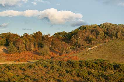
Standing high on Castle Hill, Burley (A) can be found the remains of an Iron Age hill fort dating back perhaps 2,500 years. Parts have been damaged by later gravel extraction, but a clearly visible eroded bank - the remains of a once substantial defensive rampart - and now part-filled external ditch surround a roughly oval area of around 2 hectares, recalling habitation by a long-forgotten tribe and ways of life before the Romans came to Britain. (This hill fort is at Ordnance Survey map reference SU199039).
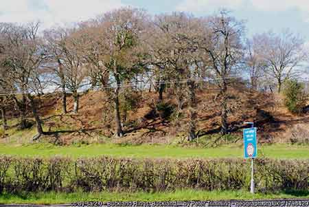
A fort of similar vintage can also be found at Buckland, a little to the north-west of Lymington, at SZ315968. There, Buckland Rings (B) is on a readily defensible hill-top site and has still-prominent, well-preserved multiple ramparts and adjacent ditches that enclose an area of around 2.8 hectares.
Nearby is Ampress Camp (C), a 2.4 hectare site at SZ321971 which it has been suggested was a possible Iron Age fort re-used at the end of the Roman period. It has, however, been much damaged, initially by ploughing when the land was under cultivation, and then by later developments and landscaping, so-much-so that the sparse remains of the fort do not even appear on modern Ordnance Survey maps.
Meanwhile at Lower Exbury (D), near the mouth of the Beaulieu River at SZ419988, a promontory fort with an internal area of 2.4 hectares is somewhat precariously positioned only a few metres above sea level. The ramparts, now much eroded, would have effectively obstructed a landward approach, as can clearly be seen on modern Ordnance Survey maps.
And at Malwood (E), near Minstead at Ordnance Survey map reference SU277121, an Iron Age fort known as Castle Malwood (but shown on the map as Malwood Castle) features the remains of a still very visible single rampart and external ditch that enclosed an area of around 1.6 hectares, whilst close by, to the south-west, the remains of a further bank and ditch are assumed to be part of an additional defensive system.
At Tatchbury (F), not far from Calmore at SU330145, are the remains of another Iron Age fort with multiple ramparts. Extensive damage to the 2 hectare site has, however, occurred - an 18th century, or earlier, country house - now demolished - and associated grounds took up a substantial part of the interior, whilst Tatchbury Mount hospital is also located on the site. The course of much of the ramparts is marked on modern maps together with the simple notation 'Tatchbury'.
Then two kilometres north-east of Fordingbridge, at Ordnance Survey map reference SU167152, is Frankenbury (G), the largest New Forest Iron Age hill fort, with a 4.5 hectares internal area. Now partially in woodland on a hill-top overlooking the River Avon, Frankenbury has somewhat confusingly also been known as Godmanescamp, Godmanescap and Godmanes Cap.
Other 'Iron Age' hill forts and enclosures
Other, often smaller, New Forest enclosures have characteristics that are said to suggest an Iron Age date, although many are on relatively level ground rather than hill-tops and none have been reliably dated by excavation finds or, indeed, by any other means. Some bear 'hill fort' names, others are simply called 'enclosures', whilst yet more carry local names.
The first to be considered here is known as Ashurst Fort (1). It is in part on open, quite flat heathland a little to the north of Matley Wood at Ordnance Survey map reference SU336085 and is simply shown on modern maps as an 'Earthwork'. The second, within Dark Hat Wood (2), south-east of the Telegraph Hill car park on the B3078 Brook to Fordingbridge Road at SU232159, is also on relatively level ground that in this case forms part of Homy Ridge - this enclosure is not shown at all by the Ordnance Survey, nor is Dark Hat Wood named. Both Ashurst Fort and Dark Hat Enclosure are relatively small with enclosed areas of 0.3 and 0.8 hectares, respectively.
Another quite small, presumed Iron Age hill fort is at Castle Hill, Godshill (3), on a ridge overlooking the Avon valley at Ordnance Survey map reference SU167162. This fort, which is thought to have enclosed an area of 0.3 hectares, was later used as the site of a Norman Ring and Bailey castle - the castle is shown on modern maps, but there is no mention of the fort.
The earthwork known as Castle Piece (4) is marked as such on the Ordnance Survey map at SU199089. It is on a gentle slope in the midst of Roe Inclosure, south-east of Linwood; whilst Sloden Green Enclosure (5) is on relatively level ground, partially within Sloden Inclosure and partially within the adjacent Sloden Wood, 2 kilometres south-west of Fritham at SU216129 - the Ordnance Survey map shows an unnamed, rounded, almost semi-circular segment of this earthwork within a far larger, meandering earthwork. Internal areas of Castle Piece and Sloden Green are 1.8 and 1.4 hectares, respectively.
Stubby Copse Fort (6), perhaps not surprisingly, is within Stubby Copse Inclosure, a little south-west of Denny Lodge at Ordnance Survey map reference SU328045. This fort does lie on a hill-top, albeit of modest height. Its internal area of 1.8 hectares is actually larger than that enclosed by the more substantial fort remains at Castle Malwood. Then at the opposite size extreme, the Knowles Enclosure (7), on a narrow hill-top within Wick Wood (SU264089), near Acres Down, features a 0.3 hectares internal area, as does Yernagates (8), sitting on what has been described as a 'hillock' a little to the north-east of Linford at SU183071. None of these three sites are shown on modern Ordnance Survey maps.
And finally we have Gorley Hill Fort (9) and New Buildings Enclosure (0), which both have larger internal areas - 3.6 and 3.7 hectares, respectively - than all other New Forest hill forts apart from Frankenbury. Gorley Hill Fort, though, on relatively level ground on Gorley Common, south-east of Fordingbridge at SU164112, has all but been destroyed by gravel extraction (including much of the rampart remains that continue to be shown by the Ordnance Survey). New Buildings Enclosure, situated on Rockford Common, south-west of Linford, at SU177084, apparently takes its name from two poor houses that were built on the site in 1835 - both have subsequently been replaced by a modern house. As with some of the other lesser 'Iron Age' enclosures, this one is on relatively level ground and is not shown at all on modern Ordnance Survey maps. The surrounding bank has poorly withstood the ravages of time and the whole has been described as 'clearly less defensive than Gorley'.
Use of the hill forts by the original occupants
No evidence of prolonged occupation has yet been found at any of the New Forest Iron Age hill fort sites, and it has been suggested that some may have been used to control the movement of people and goods along the coast and inland waterways.
Access to the hill forts
Of those that could be considered the more substantial New Forest Iron Age hill forts, Buckland Rings and the fort at Castle Hill, Burley, are most likely to repay a visit with pleasant views, clearly visible, reasonably substantial defensive banks and ditches, and ease of access - a footpath leads up to Buckland Rings from the A337, whilst Castle Hill is directly accessible from the open Forest.
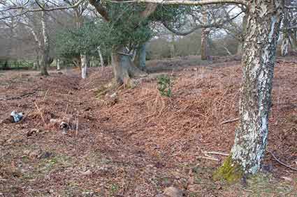
With ramparts that are readily accessible from the open Forest, Castle Malwood is also worth a visit, but as it lies within mature woodland, does not offer impressive views, nor does it offer access to the interior which is taken up by a large 19th century house and gardens.
The fort at Frankenbury is largely located on private land and much of it is therefore not readily accessible, whilst that at Lower Exbury is wholly on private land. Similarly, little of note can be seen from publicly accessible areas at Ampress and Tatchbury.
Public access from the open Forest is available to all the lesser 'Iron Age' hill forts and enclosures, although part of New Buildings Enclosure is on private land.
Further reading
For more details of New Forest Iron Age hill forts, 'Hill Forts of the New Forest National Park' by Chris Read and the New Forest History and Archaeology Group, is strongly recommended, and it is from within its pages that much useful information included here has been obtained.
References:
Proceedings of the Hampshire Field Club and Archaeological Society, Volume 54 - The Earthwork Remains of Enclosure in the New Forest: Nicola Smith
Hillforts of the New Forest National Park: Chris Read and the New Forest History and Archaeology Group
More links
Other related links
Search this site
Sadly, 58 animals were killed - 35 ponies, 13 cows, 8 donkeys and 2 sheep, whilst a further 32 were injured - 3 pigs, 9 donkeys, 11 cows and 9 ponies.
(Forty-three accidents occurred in daylight, 15 at twilight and 101 in the dark. Twenty-seven accidents were not reported by the driver involved).
Here's just one horrific example - Three donkeys killed in collision with van at notorious New Forest blackspot (Advertiser and Times)