

New Forest Walk and Cycle Ride
Denny Wood; Denny Lodge, Stubby Copse and Parkhill Inclosures; and the Frohawk Ride
This easy to follow 5 mile (8 kilometre) walk or cycle ride uses well-made tracks that pass through glorious ancient woodland and more recent, though still centuries-old, woodland inclosures.
And certainly, visits to the woods rarely disappoint, whether in winter when the trees are bare of leaves; in spring when new growth offers a subtle, fresh green palette; in summer when the canopy casts cooling shade below; or in autumn with its accompanying kaleidoscope of marvellous colours.
The route is wholly within Denny Lodge parish, a parish often said to be the largest by area in Britain. The parish was named after Denny Lodge, originally the home of a Groom Keeper - a Forest keeper of old who undertook fairly mundane day-to-day duties within his area of responsibility - and later a Head Forester's residence.
The site of Church Place, shown on the Ordnance Survey map as a 'Royal Hunting Lodge', is passed along the way and so too are the remains of a 17th century Stag Park, and Bishop's Dyke, a medieval earthen bank and ditch that is thought to have once enclosed an early 13th century deer park. Look out, also, for the wasted earthen bank and ditch associated with the fairly hard to spot Stubby Copse Fort which is thought to date back to the Iron Age.
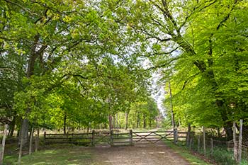
Within Denny Wood, the route passes through superb ancient and ornamental woodland - these are ancient, unenclosed woodlands commonly frequented by fallow deer, roe deer and commoners' stock. Magnificent, haphazardly spaced beech and oak trees predominate, whilst fallen giants of yesteryear litter the ground, their dead and decaying timbers much loved by always impressive, but elsewhere often increasingly scarce stag beetles.
Brambles flourish around the fallen trunks and spread-eagled limbs of venerable old trees that, when they tumbled to the ground, opened up the canopy and provided much needed light that enables pioneer plants to thrive. And so nature's cycle continues: the brambles provide nest sites, food and shelter for birds; pollen and nectar for butterflies and other insects; and nourishment for animals hardy enough to browse the prickly stems.
Coniferous woodland is also encountered along the route and so is broad-leaved inclosure woodland, much of which was originally planted with trees in the 18th and 19th centuries to provide Navy timber. Relatively regularly spaced - a legacy of that orderly planting - and now nicely mature oak and beech trees are attractively present, interspersed with scatterings of younger broadleaves and conifers.
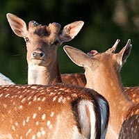
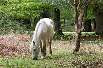
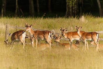
In addition to the prospect of seeing deer, wildlife highlights potentially include a wide range of woodland birds, such as great spotted woodpeckers and more elusive lesser spotted woodpeckers, nuthatches, treecreepers, stock doves and tawny owls. Look out, too, in spring and summer for spotted flycatchers, redstarts, wood warblers and in recently felled areas that support a re-growth of saplings, tree pipits.
Southern wood ants' nests may be seen along the track-sides, whilst wild flowers present may include tormentil, which is in bloom in varying numbers amongst ride-side grasses from April until October; occasional patches of bluebells; foxgloves that brighten the often dark summer woods with splashes of pinky-purple; common dog violets; wood sorrel; wood anemones and wood spurge.
In bright spring and summer weather, butterflies can also be seen in good numbers. Indeed, F.W. Frohawk (1861 - 1946), a celebrated zoological artist and butterfly enthusiast, was a regular visitor to the New Forest, so-much-so that a woodland ride along this walk route carries his name.
5 miles (8 kilometres).
Start:
The entrance to Denny Wood campsite.
Terrain:
Largely on level, firm ground with only moderate gradients.
Refreshments:
There are numerous pubs and tea rooms in nearby Lyndhurst, whilst the Drift Inn is only a short distance away, close to Beaulieu Road station.
New Forest Tour bus route: Yes - summer only
Parking
Turn off the B3056 (Lyndhurst to Beaulieu road) into the road leading to Denny Wood campsite and Denny Lodge, and, if possible, park on the gravelled area almost immediately on the left beside a long-disused, partially overgrown sand pit.
(Further limited roadside parking in gravelled 'pull-ins' may be available farther along the Denny Lodge road, beyond the campsite, for those who wish to shorten the walk route, whilst out-of-season parking may be available by the campsite. Additional alternative parking is available in the Matley Wood car park, a short distance along the road leading towards Lyndhurst).
Route directions
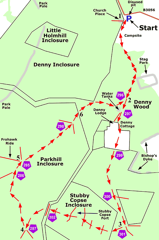
1. Continue beside the little used tarmac road leading towards Denny Wood campsite.
(A gate passed on the right, 50 metres, or so, from the parking area provides access to the wooded site of Church Place, traditionally thought to have been the location of a Royal Hunting Lodge.
All that remains now for discerning eyes to see is the well-spread - it is 3 - 4.5 metres (10-15 feet), or so, wide in places - low, linear hump of the lodge's surrounding enclosure bank and its accompanying shallow, badly silted outer ditch.
But whilst there are few visible remains here, a visit, combined with a little imagination and a sprinkling of knowledge, can none-the-less provide a humbling experience.
A woodland path actually passes through this site which is perhaps best recognised at the point where the path leaves it through a gap in the surrounding bank and ditch).
Back on the main route, continue beside the tarmac road, pass through the campsite and continue straight ahead alongside the road.
(A little to the left of the second bend in the road, around 1 kilometre (2/3 mile) from the parking area, can be found a low, wasted earthen bank and silted ditch enclosing a rectilinear area marked on modern maps as a Stag Park. This is considered to be the site of a 17th century deer park).
2. After a further 300 metres, pass a wide gravelled track on the right that is used later in this walk (cycle track post number 296).
Shortly after, pass a sign intended for drivers saying 'Access to private properties only' and almost immediately pass on the right two water storage tanks inconspicuously located in the wood - the tank on the left provides water to the nearby cottages, whilst the rightmost, now disused, provided water for the campsite - and continue downhill towards the cottages.
(Bishop's Dyke, a medieval earthen bank and accompanying ditch enclosing a quite large expanse of heath and bog, is around 300 metres, or so, away to the left here).
Take the left-hand fork in the track at cycle track post number 297, pass Denny Cottage on the left and continue straight ahead along what now is a gravelled cycle track.
(A small herd of fallow bucks can often be seen in the meadows on the left here, whilst in spring, marsh marigolds and buttercups brighten the damp, right-hand meadow).
Go through a gate and enter inclosure woodland at cycle track post number 299, continue along the cycle track and eventually pass on the left a wide gravelled track accompanied by a 'no cycling' sign - cycle track post number 300.
3. After a further relatively short distance, turn right at a crossroads at cycle track post number 301. (There is a wide grassy ride to the left here; otherwise the crossroads is a junction of cycle tracks).
Pass through Stubby Copse Inclosure.
(Look out along here for the earthen bank and external ditch that way back in the Iron Age surrounded what is now known as Stubby Copse Fort - its position is shown on the walk route map and can be seen in more detail in the section specifically relating to Stubby Copse Fort. Be aware, though, that neither bank nor ditch are prominently visible, particularly when under a growth of spring and summer vegetation).
Leave the inclosure at a gate immediately before the cycle track is intersected by a wide, grassy ride (cycle track post number 302); cross the ride; immediately go through another gate to enter Parkhill Inclosure and follow the gravel track as it goes downhill.
4. Turn right at the next cycle track crossroads (post number 287), continue for almost 1 kilometre, go right at a cycle track junction (post number 286), and after a short distance, reach another junction - cycle track post number 285.
Immediately to the left here is the Frohawk Ride.
5. Unless a detour in search of butterflies appeals, pass the Frohawk Ride, ignore at this junction a cycle track on the left and continue straight ahead along the original cycle track. Eventually reach a crossroads - cycle track post number 298 - where to the right is a grassy track and to the left a gravel track (not accessible to cyclists) and continue straight ahead.
6. After a short distance, leave Parkhill Inclosure through a gate and re-enter the open, ancient and ornamental woodland of Denny Wood.
Continue along the cycle track for around 600 metres until the road used on the outward part of the route is met at cycle track post number 296.
Turn left and retrace the route back through Denny Wood, past the campsite, to the walk start point.
Quick links
More links
Search this site