

New Forest Stag Parks
(The site of the Stag Park on the edge of Denny Wood is passed during this 5 mile New Forest walk).
Background
The New Forest was created as a Royal hunting preserve by William the Conqueror in around 1079. Royal Forests such as this reached their largest extent during the reign of Henry II (1154-1189), and in the 13th century covered around 1/5 of the country.
By the mid-14th century, however, decline had set in and by the 15th century many had fallen out of use - by 1428, for example, the deer park at Lyndhurst, bounded by what we now know as the Park Pale, was reported to be poorly maintained, although disparking does not seem to have occurred until the 16th century.
New Park, Brockenhurst, however, continued in use and was extended in 1670 by Charles II.
(1) The Stag Parks
Richardson, King, Driver and Driver's late 18th century map of the New Forest also shows three Stag Parks, all of relatively limited size - in fact, they are more the size of large corrals rather than full-blown deer parks.
All were rectangular in shape, measured around 150 metres x 100 metres, and had sharply angled corners, very straight banks and an external ditch.
They were all located within woodland, and were quite close to keeper's lodges and in at least two cases, close to sources of water.
One (A) was a little beyond Holmhill Inclosure in what is now Highland Water Inclosure, close to Highland Water and the former site of Bolderwood Lodge (SU253090).
Another (B) was close to what is now Rhinefield House, within Rhinefield Sandy's Inclosure, near to a spring and the former site of Rhinefield Lodge (SU262043).
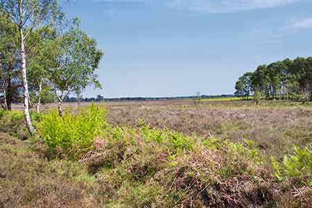
And the third (C) was on the edge of Denny Wood and the boggy area known as Shatterford Bottom, not far from Denny Lodge (SU337062).
A fourth (D) may well have existed near Burley, close to Stag Park Wood (SU204051), but other than for the name of the wood, no evidence exists for the former presence of a stag park.
(2) What can be seen and what was the purpose of Stag Parks?
The earthen surrounding banks and ditches partially survive at Rhinefield and within Highland Water Inclosure, although the latter site is heavily shrouded by vegetation.
But at the site on the edge of Denny Wood, the earthen bank, although badly eroded, survives virtually right the way around the enclosure.
It also shows on modern Ordnance Survey maps (but the other two do not) and is relatively easy to locate.
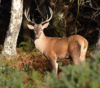
All were presumably associated with deer although their exact purpose remains unclear. It has been suggested, however, that they were created in the 17th century to hold red deer newly imported from France, the introduction that necessitated the extension of New Park.
References:
Proceedings of the Hampshire Field Club and Archaeological Society, Volume 54 – The Earthwork Remains of Enclosure in the New Forest: Nicola Smith
Quick links
More links
Search this site