

Frankenbury - the largest Iron Age hillfort in the New Forest
(The site of the Frankenbury Iron Age hillfort is passed during this fairly short, 2¾ mile New Forest walk).
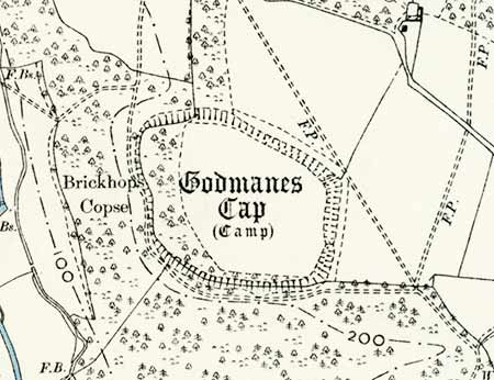
Frankenbury is the largest Iron Age hillfort in the New Forest. Somewhat confusingly, it has also been known as Godmanescamp, Godmanescap and Godmanes Cap. The 'bury' element of Frankenbury indicates a 'fortified place', whilst Godmanescamp means 'camp of God's man'.
Frankenbury is located at Godshill, near the Sandy Balls Holiday Village, close to the western boundary of the New Forest. (It lies at Ordnance Survey map reference SU167152 - shown with an 'X' on the accompanying map).
(1) A bit of background
Despite being perched in a prominent position overlooking the Avon valley near Godshill, Frankenbury appears at first glance to possess few of the typical features associated with such historic monuments.
Sure, Frankenbury is located on a hill - or to be more precise, on a slight promontory at the western edge of a plateau - with steep, tree-clad slopes to the south and west. But when viewed from afar - the fort is on private land without public access - there's little sign of an encircling ditch or rampart.
Frankenbury is, however, described by Historic England as a 'slight univallate hillfort' of probable Iron Age date (700 BC - AD 43) - 'slight univallate hillforts' are defined as 'enclosures of various shapes, generally between one and ten hectares in size, situated on or close to hilltops and defined by a single line of earthworks, the scale of which is relatively small'.
Such sites are relatively rare nationally with only around 150 examples recorded. Excavations elsewhere suggest that the majority were used for around 150 to 200 years prior to their abandonment or reconstruction. They have been variously interpreted as stock enclosures, redistribution centres, places of refuge and permanent settlements, although which of these apply to Frankenbury is unknown.
But - and it's a fairly big but that illustrates that there is often something new to discover, certainly about little-studied sites such as Frankenbury - relatively recent research by the New Forest History and Archaeology Group has identified traces of a second, ploughed outer bank running parallel to part of the northern section of the inner bank which, by my admittedly fairly basic reckoning, makes Frankenbury a multivallate fort.
(2) Frankenbury - the hillfort
The 4.5 hectare (11 acre), broadly oval-shaped site is now largely used as farmland, abutted to the north and east by further farmland, although the western section of the fort and a narrow strip along the southern edge are within woodland.
The fort and surrounds, bare of trees (as would most likely have originally been the case), would have been a far more impressive sight than presents itself today, visible from a significant distance from the south and west, a deterrent to potential aggressors who in any case would have been seen long before they arrived, enabling the occupants of the fort to prepare for defence or go out to engage the trouble-makers.
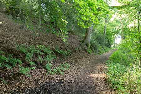
The probably artificially steepened, sharply sloping ground around the western and southern edges of the site provided a fine natural defence that largely removed the need for a man-made ditch and rampart.
But the fort builders recognised the need to construct something more elaborate facing the relatively level ground to the north and east where, according to Historic England, a single rampart remains up to 12 metres (39 feet) wide, up to 2.5 metres (8 feet) above the fort interior and up to 5 metres (16 feet) above the base of an adjoining ditch that in places has been widened and partly in-filled as a result of relatively modern ploughing, and has served as a repository for dumped farm waste.

The single original, causewayed entrance, which unfortunately has been widened through use as a modern farm track, is located close to the south-east corner; whilst a second entrance to the north is of relatively recent vintage.
Although the fort is not open to the public, a public footpath does run through the attractive mature woodland that abuts its southern and western boundaries - it has traditionally been suggested that the footpath is located in what was the fort's surrounding ditch, but, according to the New Forest History and Archaeology Group, report that no indications of a ditch were detected.
The fort has not been subject to archaeological excavation and no finds have been recorded, although Historic England note that buried remains, including traces of round houses, compounds, granaries, pits and outbuildings, can be expected to have survived within the interior of the fort.
The monument is scheduled under the Ancient Monuments and Archaeological Areas Act 1979, as amended. Despite its modest appearance, damage caused over the years by farming operations and the construction of a modern boundary bank along its southern side, it is considered to have survived well and is therefore believed to be of national importance.
References:
Proceedings of the Hampshire Field Club & Archaeological Society, Volume 54 – The Earthwork Remains of Enclosure in the New Forest: Nicola Smith
Historic England
Hampshire Place Names: Richard Coates
Hillforts of the New Forest National Park: Chris Read (New Forest History and Archaeology Group)
Quick links
More links
Search this site