New Forest coastal walks
Buckland Rings
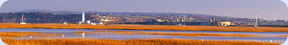
Buckland Rings is situated quite close to the A337 Lymington - Brockenhurst - Lyndhurst road, 1 mile (1.5 kilometres) north-west of Lymington town centre.
This short 1 mile walk passes around the fort's still-impressive, tree-clad ditches and ramparts and crosses the central area where all those years ago, long before the Romans arrived on these shores, people of that long forgotten era lived, worked, defended themselves and enjoyed whatever leisure time was available.
The ridge-top, almost rectangular site of this fortified enclosure stands a modest 27 metres (90 feet) above sea level and covers an area of around 2.8 hectares (almost 7 acres). It is considered to be the New Forest(s most impressive hill fort and is certainly the only well-preserved multivallate hill fort - multivallate: a fort with more than one set of ditches and ramparts.
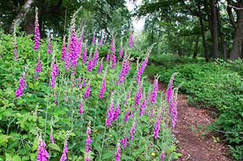
Spring is arguably the most rewarding time to visit, for then bluebells and a range of other wild flowers light up the woods, the beech foliage is at its brightest and the oaks take on their own leafy cloak. Foxgloves add a prominent splash of summer colour; autumn brings to the trees a magical array of golds, reds and yellows, and a range of mysterious fungi appear, as if from nowhere. But winter, when the woods are devoid of vegetation, provides the best opportunities to fully appreciate the structure of the fort's ditches and ramparts.
Woodland birds - nuthatches, woodpeckers, treecreepers and more - are present throughout the year, whilst in spring and summer, swallows and house martins can often be watched hawking for insects over the central meadow.
*** Find out lots more about Buckland Rings. ***
1 mile (1.5 kilometres).
Start:
Wellworthy Road, close to the hill fort.
Terrain:
Largely on level, firm ground with only minor gradients when climbing the ramparts.
Refreshments:
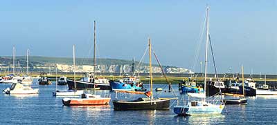
There are numerous pubs and tea rooms in Lymington, and the Tollhouse Inn is nearby to the south, beside the A337.
New Forest Tour bus route: Yes - summer only
Parking
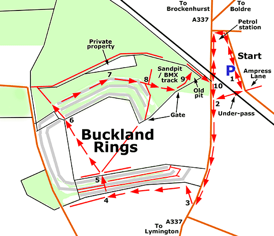
When travelling from Lyndhurst on the A337, pass a minor road on the left leading to Boldre and shortly after, at a mini-roundabout immediately before a bridge carrying the railway over the main road, take the next left turn into Wellworthy Road. Pass a petrol station on the right at this junction and park immediately after, on the right, or a little farther on, on the left. (Waiting is restricted to 4 hours in both places, with no return within 2 hours).
Route directions
A suggested route is provided but alternatives along other paths may be preferred - the site is of limited size and is largely self-contained so the risk of losing one's way is minimal and, in any case, parts are marked as walks trails: the Meadow Trail and Ramparts Trail.
1. Return to the A337 either by going back past the petrol filling station or by taking an under-pass below a railway bridge opposite Ampress Lane.
2. Continue beside the main road, heading in the direction of a mini-roundabout up ahead and cross over the road immediately before this roundabout to reach the main entrance to Buckland Rings.
3. Go by two modern sculptures inspired by art from the Iron Age period, and a useful introductory interpretation board, then after a short distance follow a well-trodden / mown, meadow-edge footpath to the left, eventually alongside the wooded ramparts of the fort.
4. When around 2/3 of the way along this meadow-edge track, go through a gate on the right - there's another useful interpretation board here: Defending the Hill Fort - that gives access to the fort's ditches, ramparts and central area; and follow the path as it first winds a little to the right and then almost immediately to the left, uphill.
Another gate at the top of the hill gives access to the fort interior and the remainder of the walk route, although detours to the left (before reaching the hill-top gate) along the outer ditch or middle rampart provide marvellous views of the fort's substantial triple ramparts and ditches, but note, after 100 metres, or so, along here, the way ahead is blocked by a fence preventing access to the private land beyond so retracing one's steps is necessary.
(Paths to the right between the two gates follow both the outer and inner ditch, and eventually lead to yet another gate that gives access to the fort interior).
5. Having followed the detours, or not, go through the hill-top gate that gives access to the fort interior and continue half-to-the-left across the meadow, following a mown path leading to another gate in the far field corner where can be found a further interpretation board: Buckland Rings - Changing Landscapes.
6. Pass through this gate; go down a short sequence of steps leading down the inner rampart; follow for a short distance a wide track leading out of the fort; after a further very short distance, pass the next rampart in sequence and immediately after, go right along a quite prominently visible footpath that after a short distance runs along the top of the outer rampart.
7. Pass a privately owned property away to the left, reach the point where the ramparts and ditches bear right at the north-east corner of the fort, and follow the footpath virtually straight ahead, almost parallel to a fence on the left (that from late spring through to autumn is hidden away by bracken and other vegetation).
(After a short distance, a path to the right provides continuing views over the ditches and ramparts until they progressively terminate close to a gate that gives access to the fort interior / meadow).
8. Continue straight ahead, then, along the original footpath; immediately pass a minor path on the left; and go on alongside a little used BMX track in a disused sandpit on the left and the meadow on the right (with another access gate here).
9. Follow the path for a short distance atop a quite narrow ridge running between the BMX sandpit and another disused, overgrown pit on the right; go down a short flight of wooden steps on the left; immediately follow the public footpath to the right, alongside the railway line, and after a very short distance, emerge onto a footpath beside the A337.
(Great care is needed when crossing the road here, particularly if children are present, as this is a very busy road, the path is very narrow and visibility is not good. Indeed, some may prefer to return across the meadow to then retrace the outward route).
10. Cross the road, go left, turn right by the petrol station and retrace the route back to the roadside parking area; or after crossing the road, go right and the left under the railway bridge to return to the parking area.
Quick links
More links
Search this site