

New Forest Short Walks - Walks from Lyndhurst
This walk passes Bolton's Bench, crosses White Moor, goes through Mallard Wood’s ancient, unenclosed woodland, and meets the Beaulieu River at Longwater Lawn.
Overview
On this walk, absorb the atmosphere of White Moor, an area with a fascinating military history. Here Victorian rifle range butts - earthen banks in front of which were placed targets - remain concealed amongst the trees, whilst engulfed in heather are the remains of trenches used during military manoeuvres prior to and during the First World War.
Follow in the footsteps of ancient travellers by walking for a while along the old Salt Way, a route leading inland from the nearby coastal salterns. Look out also for the Park Pale, a medieval earthen bank that once surrounded Lyndhurst Old Park, a deer park that dated back to at least the 13th century.
Notice too, a Bronze Age barrow still visible on the heath, the last resting place of people who inhabited this area 3,500 years, or so, ago.
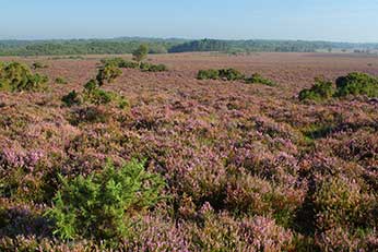
Enjoy the gorse’s yellow flowers that brighten the heaths throughout the year, and the cross-leaved heath, bell heather and common heather that blooms from June to September. Watch also for Dartford warblers, woodlarks and linnets, and from May to August, listen at dusk for the churring calls of nightjars.
In the warmer months, butterflies, too, brighten the landscape. Look out in July and early August for nationally rare silver-studded blues, and graylings from mid-July to early September.
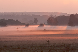
Adjacent wetland areas hold breeding season curlews that announce presence with mournful, plaintiff cries and undulating courtship flights, whilst lapwings beat the air in frenzied display, declaring territory and driving off intruders.
Marvel at the fine old oaks and beeches of Mallard Wood, an ancient unenclosed woodland that is the haunt of springtime redstarts and wood warblers, and a year-round throng of resident birds. Look out also amongst the woodland bracken for movements that might betray a deer as it slips quietly away, keen to keep from sight, for here fallow deer are common and widespread, whilst often secretive roe deer may also be seen on the heaths and in the woods.
And walk for a while beside the Beaulieu River at Longwater Lawn. In spring and summer, the river is often little more than a narrow ribbon of water, bedecked with water crowfoot, but after rain it is a more substantial water course. In winter, trout come here to spawn, whilst in their own season, brightly coloured dragonflies and damselflies dart and dance around the water’s edge.
6 kilometres (3¾ miles) from Lyndhurst village centre.
4.5 kilometres (2¾ miles) from the Bolton’s Bench car park.
Start:
Lyndhurst village centre, or from the Forestry England car park close to Bolton’s Bench.
Terrain:
Mainly on level ground, but with a small number of gentle gradients; and mostly firm, but as sections can at times be wet and muddy, strong boots are recommended.
Refreshments:
Pubs in Lyndhurst include The Fox and Hounds, The Stag, The Mailmans Arms and The Waterloo Arms. The Crown Hotel, too, serves food and drinks, and there are also numerous tearooms, cafes and restaurants.
New Forest Tour bus route:
Yes - summer only.
Parking
There is a large 'Pay and Display' car park in the centre of Lyndhurst and Forestry England car parks close to Bolton's Bench.
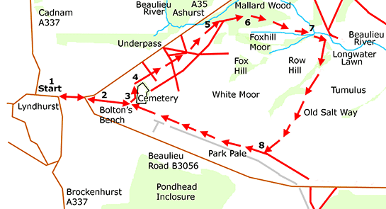
Walk route directions from Lyndhurst village centre
1. Walk straight down the High Street, ignoring opposite the garage the right turn into Gosport Lane - sign-posted Lymington and Brockenhurst. Pass on the right the old Lyndhurst Park Hotel, and almost immediately turn right following the road sign for Beaulieu. Then immediately turn left at the Forestry England Bolton’s Bench sign.
2. Pass on the left two Forestry England car parks and on the right, the hillock of Bolton’s Bench. Continue along this tarmac road, and eventually turn left along the road leading to the village cemetery - another Forestry England car park lies ahead, on the right.
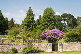
(Overlooking White Moor, the cemetery was opened in the mid-1880s when the parish church graveyard became full. Just inside the main gate is the tomb of John Wise, mid-19th century chronicler of New Forest landscape and scenery. Around the cemetery, mature conifers, a range of broad-leaved trees and extensive patches of brambles form a small copse, a haven for many species of birds and butterflies that are not often found on the adjacent, open heathland).
3. Reach the cemetery entrance and turn left alongside the wall. After a few paces, turn right to continue parallel to the wall until it again bears right. Turn left here along a grassy path bordered by bracken and brambles.
After a short distance, reach an open area of undulating ground overlooked by a bench – this is the site of an old gravel pit. Pass behind the bench, go down a slight incline and just beyond, turn right at a ‘T’ junction of narrow tracks.
Follow beside a patch of bracken on the right, which runs alongside a quite substantial overgrown trench obscured in summer by vegetation.
(Here, an adjacent, wasted earthen bank suggests deliberate excavation, rather than creation by the passage of feet and hooves. The trench may have been associated with the nearby disused gravel pit, or the village rubbish tip that until the early years of the 20th century was incongruously located close to the cemetery. But more likely it is linked to the military use of White Moor, and was used, maybe, to simulate a war-time trench).
4. Follow the path beside bracken and trench, reach the end of the cemetery-edge woodland, and go straight across at a crossroad of grassy tracks. Continue straight ahead beside a far shallower trench on the right.
Proceed along the path as it swings round to the left a short distance beyond a small clump of Scots pines and birches. After around 150 metres, reach a junction of multiple grassy tracks. Take the second exit on the right, heading for the edge of Mallard Wood.
(Notice on the right here, close to the path, two low ridges separated by a narrow area of lower lying ground – more evidence, maybe, of military manoeuvres).
5. Follow the path into the bracken adjacent to a strip of woodland on the left, and on into Mallard Wood.
(Here, a 75 - 100 metre detour to the left, through the bracken, will lead to the fledgling Beaulieu River as it meanders through the wood not far from its source at nearby Pikeshill - the river here is only 1 metre, or so, wide).
6. Back on the main route, continue through the wood, past on the right another stretch of heathland - the view of this in summer is obscured by bracken and other vegetation.
(Note the browse lines here on the hollies – the work of commoners’ stock, and deer. Note, too, the recently pollarded hollies – trees cut of at around head height to encourage re-growth).
Keep to this path as it bears to the right, take the next right fork close to the edge of the wood, and emerge onto the open heathland. Follow the path diagonally across the heath.
(Notice to the right amongst the trees, Row Hill - it was here a century ago that the White Moor, Volunteer’s Rifle Range terminated).
7. At the far side of the heath, cross a narrow side-stream at a small bridge and immediately turn left then right to follow a narrow path beside the Beaulieu River as it passes through a small copse. (Do not cross the river at this point).
Emerge onto an area of open grassland and, after a short distance, reach a small bridge over the still very narrow Beaulieu River, where set into the river bank is a parish boundary stone.
(This is Longwater Lawn, whilst across the bridge is the heathland once known as Old Ralph Heath).
Take the path leading directly away from the river, the route of the old Salt Way, as it skirts heathland on the right and an area of damp scrub on the left which eventually gives way to heathland. Bog Myrtle, Marsh St. John’s Wort and Willow are much in evidence here, illustrating just how wet this part of the walk can be.
Follow this path for just over 1 kilometre, towards The Ridge, a strip of modestly high, gorse-clad ground running parallel to the Beaulieu road.
(Short detours to the left during the early sections of this path reveal further heather-topped trenches and adjacent ridges, evidence again of military manoeuvres carried out by men in far off times, men preparing for the horrors of trench warfare.
And when level with the only group of pines beside this track, a detour to the left, to the edge of the gorse will provide for those with good eyesight or a pair of binoculars a distant view of a small, rounded hillock sitting on a ridge running parallel to the river – it lies on a line at around 65 degrees to the path. Sitting above the surrounding low-lying land, this is a Bronze Age burial mound, alone in the midst of the heath.
Away to the right, the distant church spire at Lyndhurst is visible, a beacon amongst the trees, whereas most of the village is hidden from sight; and slightly to the right, high on its hill overlooking Lyndhurst, is Northerwood House).
8. Turn right at the first ‘T’ junction of tracks, to follow the main path back towards Bolton’s Bench and Lyndhurst High Street.
(A short detour left here will reveal the Park Pale, much wasted, as its narrow neck draws close to termination).
Quick links
More links
Search this site