

White Moor
The origin of the name
White Moor adjoins Bolton's Bench, to the east of Lyndhurst. One of a number of New Forest heaths of the same name, White Moors are reputedly on sandy soils, whilst Black Down and Black Knowl names are said to refer to sites on heavier, darker soils.
John Wise, writing in the mid-19th century, though, hints at another explanation for the 'black' names, saying that bell heather (Erica cinerea) was known as black heath, so maybe places where bell heather proliferated took that name.
(Wise died in 1890, aged 59, and is buried in the cemetery on the edge of White Moor, which opened in the mid-1880s, just a few years before his death).
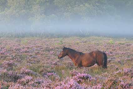
Wildlife on White Moor
But whatever the origin of the name, on this White Moor, low lying mists gather at dusk and dissipate with the rising sun, Dartford warblers cavort in heather and gorse, stonechats ring out their noisy warnings to other Forest denizens, whilst adders lurk amongst the vegetation. And at dawn and dusk, red, roe and fallow deer can all occasionally be seen.
Richardson, King and Driver's map
Old maps tell of the Moor's history. Richardson, King and Driver's late-18th / early 19th century map shows a pattern of tracks that include one labelled as a Bridle way from Beaulieu to Minstead, and another named as the Salt Way, a salt carriers route from coastal salterns to markets inland.
Peat Moor is also shown nearby, reminding of the Common Right of Turbary, the New Forest commoners' entitlement to cut peaty turf, or turves, for use as fuel for the fire.
White Moor rifle range
The 1871 Ordnance Survey map offers a little more information, and highlights one of White Moor's military associations - a Volunteers' Rifle Range which is also shown on the 1898 Ordnance Survey map, complete with Markers' Hut, Flagstaff and Target, but not on the 1909 Ordnance Survey map. The range pre-dates 1871, however, for a watercolour showing it in use, painted by Sir Charles Burrard in 1861, is held in the Christopher Tower Reference Library, Lyndhurst.
The range had a number of points from where rifles were fired, these at 50 yard and 100 yard intervals along its length - the exact distances were influenced by the lie of the land. Even today, associated earthen banks - the target butts - can still be seen amongst the trees at Row Hill, whilst mounds betray the location of firing points and markers' huts, and earthen banks remain where once was the magazine.
(The Victorian rifle range on White Moor is not the only one on the Crown Lands of the New Forest for others were present, for example at Burley, Long Bottom and Brockenhurst - Brockenhurst Rifle Range).
The Park Pale
The line of the earthen bank and ditch now known as the Park Pale shows clearly on the three old Ordnance Survey maps although alongside it on White Moor appears the label 'The Ridge'. This bank and ditch originally surrounded a medieval deer park that came to be known as Lyndhurst Old Park. The old maps show its course beyond White Moor, but nowhere is it named - presumably it became known as the Park Pale at a later date.
Other features shown on the old maps
Notice also on the old Ordnance Survey maps, the County Police Station beside the A35, the road adjacent to White Moor. Constructed in 1857, it ceased to be used by the police in 1968 when new premises were opened on Romsey Road. The old building now houses staff employed by Natural England - English Nature, as was.
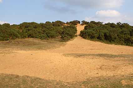
The 1870s Ordnance Survey map shows the outline of both sand and gravel pits, but neither are named until 1898. Then by 1909 the gravel pit beside the cemetery had become Old gravel pit, and now is no more than a series of ash tree-fringed grassy bumps and hollows that betray former use. The sand pit, though, remained in operation until at least the on-set of the First World War in 1914, and today remains as a deep, pale, gorse-clad scar used in part as a Forestry Commission car park.
Close to the site of the gravel pit, a mysteriously deep, often wet-bottomed hollow-way runs for 180-275 metres (200-300 yards) in a north-east / south-west direction, broadly parallel to the cemetery wall, and terminates at the gravel pit. In places, an adjacent, wasted earthen bank suggests deliberate excavation, rather than creation by centuries of passage. Was this associated with the gravel pit, or are its origins linked to the rubbish tip that up to the early years of the 20th century was incongruously located close to the cemetery? More probably, it is another link to military use, maybe as a First World War practice trench.
And finally, the 1898 and 1909 Ordnance Survey maps show part of Lyndhurst's golf course on White Moor - in 1891, the golf course spread out from its original race ground site across the A35, and remained in part on White Moor until increasing road traffic eventually forced consolidation back across the road to its present location.
Military use
White Moor was used extensively by the military during the First World War. Follow the link below for lots more information and numerous pictures from that period.
Find out more about White Moor
References:
The New Forest: Its History and Scenery: John R. Wise.
Lyndhurst Historical Society publications: Roy Jackman
Lyndhurst - A Brief History and Guide: Georgina Babey and Peter Roberts
More links
Other related links
Search this site
Sadly, 58 animals were killed - 35 ponies, 13 cows, 8 donkeys and 2 sheep, whilst a further 32 were injured - 3 pigs, 9 donkeys, 11 cows and 9 ponies.
(Forty-three accidents occurred in daylight, 15 at twilight and 101 in the dark. Twenty-seven accidents were not reported by the driver involved).
Here's just one horrific example - Three donkeys killed in collision with van at notorious New Forest blackspot (Advertiser and Times)