

Brockenhurst Rifle Range
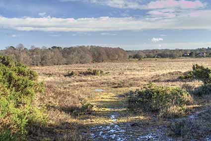
looking back from Five Thorns Hill
along the line of the first range
Brockenhurst Rifle Range was located to the west of the village centre, and ran from close to North and South Weirs, to terminate on, and later near, Five Thorns Hill.
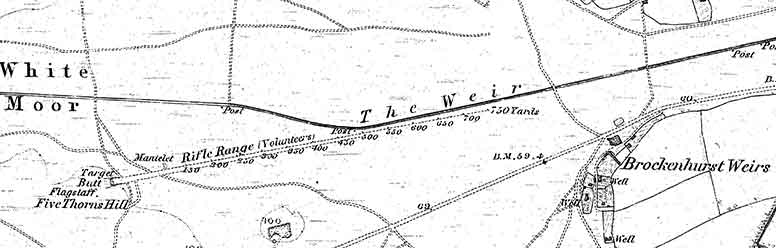
The Rifle Range shown on the 1870, 1st edition, 6" to the mile, Ordnance Survey map was set-up following the nationwide establishment of Rifle Volunteer Corps.
On this map, a 750 yard Rifle Range (Volunteers) is shown, running from a target, butt and flagstaff on Five Thorns Hill, in an east-north-east direction, eventually alongside The Weir. The presence of a Mantelet – a bulletproof shelter or screen - is also marked.
Today, no evidence has been found of the butt, although a narrow, quite wet, channel runs up the hillside on the approximate line of the rifle range, terminating towards the top – maybe the butt and targets were positioned at the channel’s end.
On the 1898 2nd edition of the map, the butt is marked as disused, and nothing else is shown: whilst on the 1910 3rd edition, a nearby new 1,000 yard rifle range has appeared on a broadly east-west alignment, with butts and targets located to the north of The Weir. Local geography – boggy ground and hillocks - presumably prevented the original line from being extended to reflect the greater firepower of later weaponry.
(Presumably, the perceived late-1850s / 1860s threat from the French receded and the first range consequently fell into disuse, whilst international uncertainties that eventually led to the First World War (1914-1918) prompted the creation of the second Rifle Range).
Today, evidence of concrete foundations can be found amongst the gorse on a small hillock on the approximate site of the later butt, whilst an adjacent small pit may have supplied the material from which the butt was constructed.
At some time after 1921, Beaulieu rifle range apparently moved onto this or a nearby site, which was again used as a Rifle Range during the Second World War.
Find out more about Volunteer Rifle Ranges:
Reference:
Before We Go, Brockenhurst Memories of Peace and War: compiled by Richard Taylor
More links
Other related links
Search this site
Sadly, 58 animals were killed - 35 ponies, 13 cows, 8 donkeys and 2 sheep, whilst a further 32 were injured - 3 pigs, 9 donkeys, 11 cows and 9 ponies.
(Forty-three accidents occurred in daylight, 15 at twilight and 101 in the dark. Twenty-seven accidents were not reported by the driver involved).
Here's just one horrific example - Three donkeys killed in collision with van at notorious New Forest blackspot (Advertiser and Times)