

Explore Hatchet Pond, Rans Wood, Hawkhill Inclosure, Beaulieu Heath and Bagshot Moor
A circular New Forest walk and cycle ride
The sites of the Second World War, RAF Beaulieu airfield and the First World War, East Boldre Airfield are also passed along the way.
Overview
This 5 mile (8 kilometres) walk is primarily on level ground, although there are a small number of relatively gentle inclines. Much of the walk is along off-road cycle routes, whilst the remainder follows a footpath across a section of Bagshot Moor which, despite the name, is actually fairly dry other than in winter and after heavy rain.
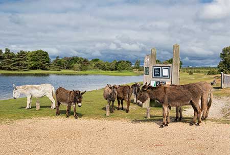
The route starts in the Hatchet Pond car park, one and a quarter miles (2 kilometres) from Beaulieu village centre.
Please note that cyclists should not ride across Bagshot Moor - there is no access for cyclists - but instead should follow the B3054, Lymington to Beaulieu road, back to Hatchet Pond.
Part of the route includes sections of the separate East Boldre Airfield walk and the RAF Beaulieu walk and, as such, there is potential for combining parts of this walk with elements of the other two routes.
The walk will be enjoyed by those who simply want a pleasant stroll through a wonderful landscape, and will also be appreciated by history and wildlife enthusiasts.
Along the way
The route passes through marvellously varied landscapes starting with the area around Hatchet Pond. Extensive areas of heathland are present and there is ancient and ornamental woodland in Rans Wood followed by Hawkhill's broad-leaved and coniferous inclosure woodland. There are even distant views of the rolling hills of the Isle of Wight to enjoy.
During the walk, those with even a passing interest in New Forest wildlife will rarely be disappointed - varied landscapes usually mean varied habitats which in turn often provide homes for a huge range of wildlife. Perhaps of particular note are the mute swans and their cygnets, and other water birds on Hatchet Pond; the scarce and not so scarce wild flowers around the pond, on the heaths and in the woods; heathland birds such as linnets, stonechats and Dartford warblers; woodpeckers, nuthatches and other woodland denizens and, of course, the prospect of seeing roe deer, fallow deer and maybe even sika deer.
Neither will those with an appreciation of the past lack things of interest to hold their attention. Look out, for example, for Bronze Age barrows and the relics of two airfields: one, East Boldre Airfield, dates back to before the First World War, whilst the other, RAF Beaulieu, is of Second World War vintage.
5 miles (8 kilometres).
Start:
Hatchet Pond car park - one and a quarter miles (2 kilometres) from Beaulieu village centre.
Terrain:
Largely on level, firm ground but with a small number of moderate gradients. Please note that the Bagshot Moor element of the walk can be wet underfoot in winter and after heavy rain. The use of strong, waterproof boots is therefore recommended at these times.
Refreshments:
There are a number of pubs and tea rooms in and around East Boldre and Beaulieu, for example, the Turfcutters Arms at East Boldre, the Montagu Arms Hotel in the centre of Beaulieu village and the Royal Oak at Hilltop.
New Forest Tour bus:
Yes - summer only, along the B3054, which forms part of the walk route.
Parking
Park in the Hatchet Pond car park at the start of the walk.
Alternative parking is available in the Beaulieu Heath car park, the Hawkhill car park and at Rans Wood, but please be aware that the Beaulieu Heath car park in some years is closed in the spring so as to reduce disturbance to ground nesting birds.
(Details of car park closures are here).
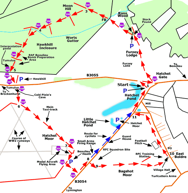
Walk route directions
1. Leave the Hatchet Pond car park by its main entrance; cross the at times quite busy adjacent B3055, the Brockenhurst to Beaulieu road; turn right and after a short distance, at cycle track post number 343, go left along Furzey Lane, a narrow country lane leading to residential properties and eventually to Rans Wood.
(Furze, sometimes shortened to Fuzz, is a commonly used local name for gorse, a well-known spiky bush found on many New Forest heaths and along woodland margins).
Continue straight ahead where Furzey Lane gives way to Furzey Lodge.
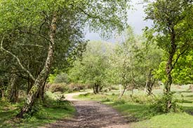
2. Follow the now gravelled cycle track to the left past a Forestry Commission car park and on through Rans Wood, a small but nevertheless extremely attractive area of ancient and ornamental woodland, a pocket masterpiece recalling the character of English woodlands of old.
(A stock pound beside the left turn, Furzey Lodge Pound, has been dedicated by the commoners of the New Forest to Jeffrey Kitcher, MBE, 1943-2011, in recognition of his dedication to forestry and commoning. The pound, as with other similar pounds, is used to temporarily hold ponies rounded up during the annual New Forest pony drifts).
Pass cycle track post number 341, follow the track downhill and after a relatively short distance pass through a gate to enter Hawkhill Inclosure. Immediately after the gate, cross a railed bridge over a stream, the oddly named Worts Gutter, and continue straight ahead.
(In the New Forest, small streams are often known as gutters but the derivation of Worts is a puzzle).
3. Follow the cycle track to the left at cycle post number 340 - ignore here a quite wide grassy ride that goes on straight ahead.
Continue straight on, downhill, at cycle track post number 339, ignoring here a quite wide grassy / gravely track to the left.
Similarly, after walking up a moderate incline, pass cycle track post number 338, ignoring here a gravel track going off to the left.
Continue straight ahead again, now downhill.
4. After a relatively short distance, at the bottom of the hill, take the left-hand fork at a 'Y' junction of gravel cycle tracks - cycle track post number 337.
Continue up a gentle incline and as the track bears a little to the left, pass a grassy ride on the right. Go straight ahead, now alongside coniferous woodland on the left and an extensive area of clear-fell on the right.
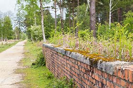
(After around 300 metres, as the ground levels out, notice a large bracken-covered earthen bank a short distance away to the left upon which have rooted well-grown conifers and other trees; and behind the bank, a low, brick built and in places concrete topped wall, a reminder of the Second World War, RAF Beaulieu, Bomb Preparation Area that was located here - this backs onto the remains of one of two bomb stores, and was presumably a loading platform).
Almost immediately, as the gravel track gives way to fractured, Second World War vintage concrete, pass cycle track post number 344 and continue straight ahead where the concrete track is intersected by a gravel track.
(A detour to the left here gives access to further service roads and other reminders of Second World War usage.
A few metres beyond this crossroads, notice on the right, quite close to the track, a low, not particularly prominent, circular mound on which coarse grasses and bracken have taken hold - this is a Bronze Age burial mound, a barrow, a tumulus that unlike many others hereabouts was spared destruction when the wartime installations were constructed).
Follow along the concrete track; pass on the left another low, brick-built wall that again in places is topped with concrete - this backs onto the remains of the second bomb store; and opposite, running alongside the right-hand side of the concrete track, another substantial earthen bank.
(Attached to the wall is a very informative interpretation panel that includes a Second World War plan of the site).
5. Pass cycle track post number 345, leave Hawkhill Inclosure through a pedestrian gate and enter an area of open heathland. Pass cycle track post numbers 346 and 347, located incongruously close to post number 345, and on the left, a gravel / concrete track leading to the Hawkhill car park.
Cross the B3055, the Brockenhurst to Beaulieu road, and continue straight ahead, past a low, vehicle barrier and cycle track post number 348, along the still-concrete surfaced track leading onto the site of the old airfield, a landscape of wide open spaces, heather, gorse and close-cropped grasslands resting under huge skies.
(Notice on the right immediately after crossing the road, another, this time more prominent, circular mound, a tumulus that shows in lumps, bumps and hollows, substantial signs of past excavation. This Bronze Age barrow - popularly known in the distant past as Cold Pixie's Cave - is another fortunate survival following the all-too-necessary depredations of the Second World War).
6. After around 250 metres, at a 'T' junction, pass cycle track post number 319 and go left along a tarmac-surfaced track - the remains of the old airfield's main taxi-track.
(After a short distance, as the track bears slightly right, the site of one of the airfield's runways can be seen running away into the distance on the right - the surface concrete and tarmac was removed in the 1990s although bits left behind can in places still be seen.
The outlines of aircraft dispersal pans, places where aircraft were parked when not in use, are still visible on the left along here, albeit less so on the ground than from the air using Google Maps satellite view).
7. Pass cycle track post number 320 and continue over a relatively wide area of concrete beside on the right the Model Aircraft Flying Area.
(The Model Aircraft Flying Area comprises an expanse of concrete and a separate, adjacent area of asphalt / tarmac. The concrete formed the easterly end of the main, east / west runway, whilst the asphalt / tarmaced area to its left was set down in the 1950s during the airfield's 'stand-by' years.
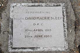
The first Beaulieu-based pilot to sink a U-boat was Squadron Leader David Mackie Sleep, DFC, in October 1942. The event is commemorated in a panel set into concrete close to the eastern end of the main runway. Squadron Leader Sleep's ashes, fittingly, were scattered on the airfield following his death in June 1989).
Follow the cycle track as it bears round to the right and at cycle track post number 321, go left along a more substantial gravel track.
Take the next left turn at a 'T' junction of gravel tracks - at cycle track post number 322. After a relatively short distance, reach the B3054, the often busy Lymington to Beaulieu road, at cycle track post number 323, and go left along the road.
8. Cyclists should continue straight ahead along the road to rejoin the main route close to Hatchet Pond.
Walkers should, after around 200 metres, cross over the road and follow a fairly pronounced gravel / grassy track leading over the extensive heathland of Bagshot Moor, the site of the First World War, East Boldre Airfield. (This track is alongside a small, bare area of roadside gravel used as an informal parking place. Three low, wooden 'dragon's teeth' here prevent further vehicle access).
(Before crossing the road, the remains of part of the East Boldre Airfield, Small Arms Firing Range - an eroded bank now inhabited by rabbits, and shrouded in vegetation - can be seen on the left, a little farther on.
After walking a short distance along the gravel / grassy track - perhaps 100 metres from the road - to the left of the track, evidence of First World War usage as the Royal Flying Corps, Squadron Site is prominently visible).
9. When around 150 metres from the road, follow the main track to the left, heading in the direction of houses stretched along the roadside at East Boldre, one kilometre, or so, away.
Almost immediately pass, set into the path, part of the foundations of one of the double truss hangars that were located in the Squadron Site, and continue straight ahead, ignoring other minor tracks to left and right.
Later along the way, pass other strips of concrete set into / close to the track, and at least one other building platform.
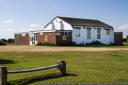
Eventually bear slightly right to reach East Boldre Village Hall, the one-time Officers' Mess and later YMCA facility, where can be found an information panel setting out details of East Boldre Airfield's history.
(The Turfcutters Arms is a short distance away along the road to the right from here).
10. Turn left and continue along the roadside heathland, pass the village post office and stores on the right, and after around 500 metres, follow the road to the left at a fork.
(Hatchet Mill, originally a corn mill but now a private residence, is straight ahead on the right at this fork).
11. Reach the B3054, cross over and turn right, along a track that passes beside Hatchet Pond and continues on to the walk start point.
Quick links
More links
Search this site