

A walk around the site of East Boldre Airfield, an airfield that dates back to the early days of flight
Overview
This 1½ mile (2.5 kilometres) walk is entirely on level ground with no hills along the way. The route starts from close to the post office in East Boldre, which is almost two miles (3 kilometres) from Beaulieu village centre.
East Boldre Airfield is adjacent to the Second World War RAF Beaulieu airfield and there is potential to combine this walk route with a walk around RAF Beaulieu to create an extended figure-of-eight route of around 5¼ miles (8.25 kilometres).
The walk will be enjoyed by those who simply want a pleasant stroll through an attractive landscape, and will also be appreciated by history and wildlife enthusiasts.
Along the way
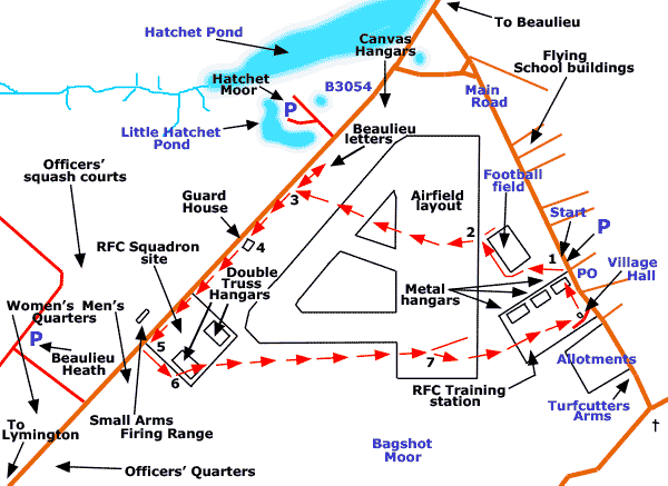
The accompanying map shows the walk route super-imposed upon the original layout of the airfield. However, no airfield buildings remain standing apart from East Boldre Village Hall, which originally housed the officers' mess and a later YMCA facility. Nor is there evidence on the ground of the airfield runways although building foundations and other reminders of the airfield are still to be seen.
For example, the outlines of three metal hangars, located within what was the Royal Flying Corps, Training Station, are immediately adjacent to the parking area near the post office, along with numerous other bumps and hollows, building outlines and remnants of concrete between the hangars and the village hall. And then mid-way through the walk, the old Royal Flying Corps, Squadron Site is passed where the outlines of two large double truss hangars can be seen alongside the remains of other airfield structures.
*** Find out lots more about East Boldre Airfield. ***
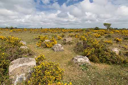
But there's more to this walk than airfield history for the route is over heathland with wet ground nearby, so a range of wildlife may well be encountered, particularly in the spring and summer. Look out, for example, for Dartford warblers, stonechats and linnets; and watch and listen at dusk for enigmatic nightjars.
Then depending upon the season, wild flowers such as heath spotted-orchids and tormentil may be present, whilst butterflies encountered may include silver-studded blues, graylings and a range of other species. And to add to the variety, dragonflies and damselflies, and breeding curlews and the occasional redshank may wander over the heath from the adjacent wetland areas.
Lots more information about New Forest heathlands can be found here - New Forest heathlands - whilst wetland habitats are described here - Valley mires and other wetlands.
1½ miles (2.5 kilometres).
Start:
Opposite East Boldre post office.
Terrain:
Level, largely firm ground. Please note, however, that parts of the route can be wet underfoot in winter and after heavy rain. The use of strong, waterproof boots is therefore recommended at these times.
Refreshments:
There are a number of pubs and tea rooms in and around East Boldre and Beaulieu, for example, the Turfcutters Arms at East Boldre, the Montagu Arms Hotel in the centre of Beaulieu village and the Royal Oak at Hilltop.
New Forest Tour bus:
Yes - summer only, along the B3054, which forms part of the walk route.
Parking
Limited parking is available opposite East Boldre post office at the start of this walk.
Alternatively - and this will be an attractive option to users of the New Forest Tour bus and maybe also to those who wish to combine this walk with the walk around the adjacent site of the Second World War, RAF Beaulieu airfield - parking is also available in the Beaulieu Heath car park on the B3054, Lymington to Beaulieu road, which is close to the start of section 5 of this walk. But please be aware that the Beaulieu Heath car park in some years is closed in the spring so as to reduce disturbance to ground nesting birds.
Parking is also available in the Hatchet Moor car park - close to the Beaulieu Letters, and again on the route of the New Forest Tour bus.
(Details of car park closures are here).
Walk route directions
1. Walk across the heath to the diagonally opposite corner of the nearby football field - in 2019, a wooden post marked this spot.
2. From the corner of the football field, follow a heathland path to the left, through the gorse. Continue along this 'main' grassy / sandy / soil path in the direction of the B3054 Lymington to Beaulieu road, ignoring minor paths to left and right.
(The path is not always clear along here, but the location of the road ahead is fairly obvious).
3. Reach the road, but beware, this is well-used, particularly as a commuter route, so be sure to take care.
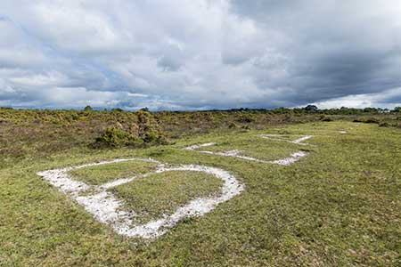
The Beaulieu letters
Almost opposite the entrance to the Hatchet Moor car park are huge, pale letters laid out on the ground, spelling the word BEAULIEU. Each letter is around 15 feet (4.5 metres) high and the whole word spans around 110 feet (33.5 metres). The origin of the letters is something of a mystery but it has been assumed that they were put in place in the days of the flying school.
Directions
Turn right and continue along the roadside for a short distance; go right again, onto the heath directly opposite the Hatchet Moor car park entrance; almost immediately take the right-hand fork in the narrow heathland path; virtually reach the far edge of the corridor of roadside gorse (where the gorse gives way to open heath) and then go right to find the letters a short distance away.
Return to the roadside and go left, towards Lymington. Bumps and hollows along the way, their derivation often long forgotten, remind of past usage of this area.
4. When around 400 metres from the Hatchet Moor car park entrance, look out for a line of three short, weather-worn wooden posts, 'dragon's teeth' placed to prevent cars encroaching onto the heath.
(Adjacent to the posts, set into the ground, are a number of bricks on a concrete foundation and the outline of a small building. These are the remains of the East Boldre Airfield guard house used to confine airmen or ground staff guilty of a range of misdemeanours).
After a further 150 metres, or so, pass an unofficial parking place with two short, adjacent 'dragon's teeth' preventing vehicular access to a fairly wide grassy track.
Continue for a further 200 metres, or so, and reach another unofficial parking place - a small, bare area of roadside gravel with three adjacent 'dragon's teeth' - this is a short distance before on the right, the access road to the Beaulieu Heath car park.
(The remains of part of the East Boldre Airfield, Small Arms Firing Range - an eroded bank now inhabited by rabbits, and shrouded in vegetation - are on the right, just across the road close to here).
5. Go left by the 'dragon's teeth' along a quite pronounced gravel / grassy track, heading back in the direction of the distant houses of East Boldre.
(After walking a short distance along the gravel / grassy track - perhaps 100 metres from the road - to the left of the track, evidence of First World War usage as the Royal Flying Corps, Squadron Site is prominently visible).
6. When a further 50 metres from the road, follow the main track to the left, heading in the direction of the houses stretched along the roadside at East Boldre, one kilometre, or so, away.
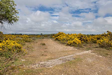
Almost immediately pass, set into the path, part of the foundations of one of the double truss hangars that were located on the Squadron Site, and continue straight ahead, ignoring other minor tracks to left and right.
Later along the way, pass other strips of concrete set into / close to the track, and at least one other building platform.
7. Eventually bear slightly right to reach East Boldre Village Hall, go left and the village post office is a short distance away on the right.
(Upon reaching the village hall, the Turfcutters Arms is a short distance away along the road to the right).
Quick links
More links
Search this site