

RAF Beaulieu - a heathland walk around the site of the old Second World War airfield
Overview
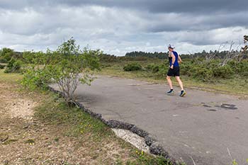
This easy to follow 3½ mile (5.5 kilometres) route offers a fairly gentle stroll over open heathland. It is on level ground with virtually no gradients, and is mostly all along firm gravel / concrete tracks.
The undulating chalk hills of the Isle of Wight are silhouetted against the sky to the south, whilst Sway Tower is around 4½ miles (7.5 kilometres) to the south-west.
The Second World War, RAF Beaulieu airfield - sometimes also known as Beaulieu Airfield - is adjacent to the pre-First World War, East Boldre Airfield and there is potential to combine this walk route with a walk around East Boldre Airfield to create an extended figure-of-eight route of around 5¼ miles (8.25 kilometres).
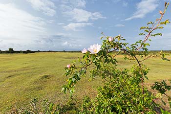
The walk will be enjoyed by those who simply want a pleasant stroll through a wonderful landscape, and will also be appreciated by history and wildlife enthusiasts.
Along the way
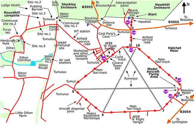
The route follows the course of the main taxi-track around the perimeter of RAF Beaulieu's lengthy but fast disappearing runways. The route is marked on the accompanying map by arrows, but other aspects of the airfield are also shown for general information and also for those who might wish to explore more widely.
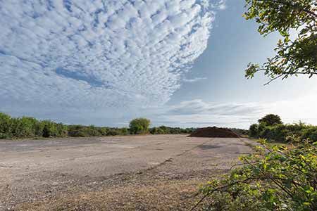
The runway layout is most clearly seen from above using, for example, Google Maps satellite imagery. Dispersal pans - aircraft 'parking' places around the airfield - are also often best located using Google's satellite images.
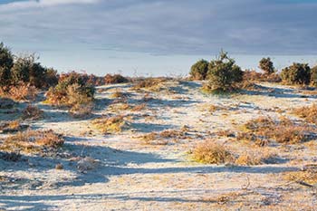
Nowadays, however, nature is fast reclaiming the outlines of the old runways, particularly in spring and summer when the vegetation is at its most luxurious. Eventually many signs of the past will be gone forever, a situation lamented by those with an interest in the history of this fascinating area but welcomed by many New Forest commoners who value every last bit of grazing land.
*** Find out lots more about RAF Beaulieu. ***
But there's more to this walk for history enthusiasts than RAF Beaulieu, for a number of Bronze Age barrows - shown on the map as tumuli or tumulus - are passed along the way. These centuries-old burial mounds typically date back to the early-middle Bronze Age around 3,500 years ago.
And, of course, as this is a heathland walk, a range of fascinating wildlife is likely to be present, particularly in the spring and summer. Look out, for example, for heathland birds such as Dartford warblers, stonechats and linnets; and watch and listen at dusk for enigmatic nightjars.
Then depending upon the season, wild flowers such as heath spotted-orchids and tormentil will be present, whilst butterflies encountered may include silver-studded blues, graylings and a range of other species. And to add to the variety, dragonflies and damselflies, and breeding curlews and the occasional redshank may wander over the heath from adjacent wetland areas.
Lots more information about New Forest heathlands can be found here - New Forest heathlands.
3½ miles (5.5 kilometres).
Start:
Hawkhill car park.
Terrain:
Level, firm ground.
Refreshments:
There are a number of pubs and tea rooms in and around East Boldre and Beaulieu, for example, the Turfcutters Arms at East Boldre, the Montagu Arms Hotel in the centre of Beaulieu village and the Royal Oak at Hilltop.
New Forest Tour bus:
Yes - summer only, along the B3054, close to the walk route.
Parking
Park in the Hawkhill car park on the B3055, Brockenhurst to Beaulieu road.
Alternatively - and this will be an attractive option to users of the New Forest Tour bus and maybe also to those who wish to combine this walk with the walk around the site of the adjacent First World War, East Boldre airfield - parking is also available in the Beaulieu Heath car park on the B3054, Lymington to Beaulieu road, which is passed through during section 7 of this walk. But please be aware that the Beaulieu Heath car park in some years is closed in the spring so as to reduce disturbance to ground nesting birds.
(Details of car park closures are here).
Walk route directions
1. Leave the Hawkhill car park by its main entrance and walk towards the B3055. Pass on the right cycle track post number 347 alongside a strip of Second World War vintage concrete track that is now part of the cycle network.
2. Cross the at times quite busy road.
(Notice on the right at this junction the fairly conspicuous raised mound of a Bronze Age barrow known in the past as Cold Pixie's Cave, one of the fortunate few to escape the all too necessary destruction wrought during the airfield's construction).
Pass a low, vehicle barrier and cycle track post number 348, and continue along the cycle track that here is primarily surfaced with aged, broken concrete, another reminder of Second World War usage.
3. After around 250 metres, reach a 'T' junction at cycle track post number 319 and go right, along a wide, initially tarmaced track that once formed part of the airfield's main taxi-track.
(Almost immediately on the left here, a wide expanse of short-cropped turf interspersed with invading shrubs, runs away into the distance - this is the site of the north-western end of the north-west / south-east oriented runway).
Follow the cycle / taxi-track as it bears left close to the course of the old runway.
(After around 250 metres, notice a wide expanse of concrete on the right that in 2019 was partially in use for the storage of bracken cut from the Forest and shredded. This area was previously the site of much activity for the concrete formed the base of the Airborne Forces Experimental Establishment (AFEE) 'B' Flight hangar; whilst the site of the airfield control tower, fire tender shelter, and floodlight trailer and tractor shed is directly opposite, across the main taxi-track).
4. Ignore the course of the cycle track as it goes off to the right alongside the concrete hangar base - at cycle track post number 318 - and instead continue straight ahead along a prominent but rutted gravel (with occasional bits of concrete) track that follows the line of the original main taxi-track.
(The remains of another Bronze Age barrow, or tumulus, can be seen on the right here).
Pass a section of building foundation let into the taxi-track and when around 750 metres from the concrete hangar base, follow the track as it bears left.
(On the left here is the site of another runway, this one running in an east-west direction. A short walk along the right-hand edge of this runway will reveal regularly spaced rectangular concrete outlines in the turf, presumably the remains of runway light holders).
5. Return to the walk route and continue straight ahead along what here is a rutted part-gravel / part-dirt track.
After around 200 metres, ignore a fairly wide, grassy track on the right that leads to the site of a number of aircraft dispersal pans - the outlines are still visible on the ground and are clearly visible when using the satellite view provided by Google Maps. (Many aircraft dispersal pans were located right the way around the main taxi-track, on the side away from the runways).
After a further 200 metres, ignore another track on the right, this one eventually with concrete showing through before it bends round to the left as a wholly concrete surfaced trackway - this led to another aircraft dispersal pan alongside which were the Heavy Equipment Workshops, two stores and a battery charging room.
6. After another 250 metres, as the course of the main taxi-track bears left, pass on the left the end of the increasingly vegetated north-east / south-west oriented runway.
Continue along the main taxi-track ignoring on the right a grassy track with bits of gravel, concrete and brick showing through - this led to the AFEE 'A' Flight hangar and associated structures.
Pass another fairly wide grassy / gravel World War Two vintage track on the right that led to aircraft dispersal pans and the 'A' Flight hangar, and continue straight ahead.
7. Pass on the left the end of the north-west / south-east oriented runway and follow the main taxi-track as it again bears left.
After a short distance, pass beside a Forestry Commission vehicle barrier and continue straight ahead through the Beaulieu Heath car park.
Ignore a track / roadway on the right leading to a parking area that is almost certainly located in an old, aircraft dispersal pan; and immediately after, pass another roadway on the right, this leading to the B3054, the Beaulieu to Lymington road, at cycle track post number 322.
8. Follow the main taxi-track, now a cycle track again, as it bears a little to the left.
(Further to the left here is an expanse of concrete and a separate, adjacent area of asphalt / tarmac. The concrete formed the easterly end of the main, east / west runway, whilst the asphalt / tarmaced area to its left was set down in the 1950s during the airfield's 'stand-by' years. Both are now used as a model aircraft flying area.
The first Beaulieu-based pilot to sink a U-boat was Squadron Leader David Mackie Sleep, DFC, in October 1942. The event is commemorated by a panel set into concrete close to the eastern end of the main runway. Squadron Leader Sleep's ashes, fittingly, were scattered on the airfield following his death in June 1989).
Almost immediately, at cycle track post number 321, ignore a left turn leading to the Model Aircraft Flying Area and instead follow the main track as it bears first to the right and then almost immediately to the left.
Walk over an area of tarmac / asphalt and after a short distance pass another Forestry Commission vehicle barrier at cycle track post number 320.
9. Continue straight ahead along the main tarmac / asphalt track.
(Bits of concrete are present along the sides of this section of track, whilst 350 metres, or so, from cycle track post 320 can be seen on the right a quite small, broadly triangular shaped area of relatively bare ground with concrete rubble strewn on the surface - this is at the entrance to an aircraft dispersal pan).
10. After a further 500 metres, follow the taxi-track as it bears a little to the left.
(On the left here is the end of the north-east / south-west oriented runway which at this point is noticeably below the level of the taxi-track, reflecting the extent to which the runway surface was stripped away in the 1990s).
Shortly after, reach cycle track post number 319 and turn right to retrace the outward route back to the Hawkhill car park.
Quick links
More links
Search this site