

Beaulieu Airfield - a New Forest, Second World War airfield
(Beaulieu Airfield can be explored during this walk around the site and also during this extended walk that also takes in Hatchet Pond and more).
Beaulieu Airfield was one of eleven Second World War airfields located in and around the New Forest. It was also known as RAF Beaulieu, Beaulieu Aerodrome and USAAF Station AAF 408.
But why Beaulieu at all could be considered to be something of a mystery as the closest village centre is that of East Boldre, although the Beaulieu parish boundary is close by and the airfield was located on Beaulieu Heath.
East Boldre had, however, been the base for one of the UK's first airfields in the early days of powered flight, for in 1910 a flying school was established just across the Lymington to Beaulieu road from the Second War Airfield. The site was again used in the First World War for Royal Flying Corps pilot training, and was also known from 1918 until closure in 1919 as RAF Beaulieu.
But the East Boldre site was not suitable for use by the much larger aircraft used during the Second World War, nor could it accommodate the significantly increased volumes of traffic and the necessary associated infrastructure, so the Second World War airfield was located nearby but on a new site more suited to the needs of the time.
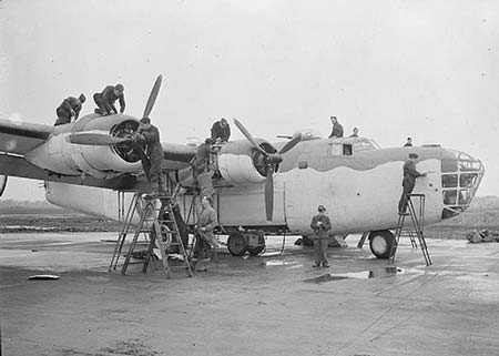
(1) Beaulieu Airfield - construction and layout
Constructed during 1941 and 1942, the airfield became operational in August, 1942 and was one of three relatively large New Forest airfields - the others were Stoney Cross Airfield and Holmsley Airfield.
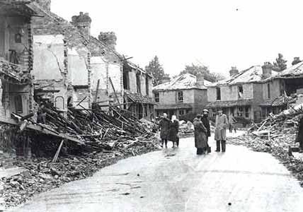
Brick rubble was brought in from bombed areas, such as Southampton, for use in the runway and perimeter track foundations - this certainly gives pause for thought when bits of old brick are encountered now when walking the site.
(Image courtesy of the RAF Museum)
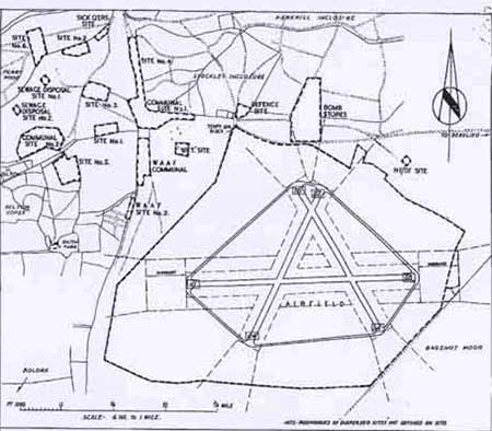
Beaulieu was a large airfield, certainly by the standards of the time. The runways alone covered around 570 acres, whilst living accommodation and ancillary facilities, located to the north-west of the runways, were spread out over a similarly sized area.
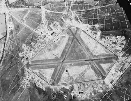
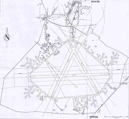
The airfield's three runways were set out in the shape of an enormous letter 'A' - a standard layout at the time for RAF airfields, subject to site topography - so as to provide take-off and landing facilities whatever the wind direction: prevailing winds here are from the south-west.
(Image courtesy hampshireairfields.co.uk)
The runway forming the cross section of the 'A' ran in an east-west direction and was over a mile long at 1,967 yards, whilst the other two runways were 1,366 and 1,367 yards long.
(Image courtesy of the RAF Museum)
(2) Beaulieu Airfield's ever-changing role
Beaulieu airfield was used as the base for a variety of aircraft needed to support rapidly developing theatres of war. Although other relatively short-stay visits no doubt occurred, here's an overview of the main occupants from the airfield's early days right the way through to the land being handed back to the Forestry Commission.
Early September, 1942 to February, 1944 - U-boat patrols to protect Allied shipping convoys
During this period, the airfield was the base for Coastal Command long range bombers, such as the Liberator and Halifax, and shorter range bombers used to patrol the eastern Atlantic in efforts to prevent U-boat attacks on convoys moving troops and supplies from Britain and the USA to fight in the North African Campaign.
(Image courtesy hampshireairfields.co.uk)
The first Beaulieu-based pilot to sink a U-boat was Squadron Leader David Mackie Sleep, DFC, in October 1942. The event is commemorated in a panel set into concrete close to the eastern end of the main runway. Squadron Leader Sleep's ashes, fittingly, were scattered on the airfield following his death in June 1989.
February to June, 1944 - D-Day preparations and support for the invasion
In February, 1944, after Allied victory in North Africa, Coastal Command aircraft made way for fighter-bombers brought in prior to Operation Overlord, the invasion of mainland Europe that began with the 6th June, D-Day Normandy Landings.
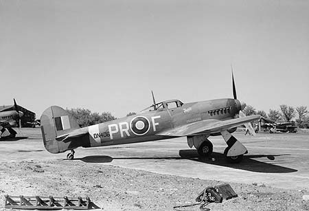
(Image courtesy of the Imperial War Museum)
Hawker Typhoons flown by the RAF and the Royal New Zealand Air Force, assisted for a short time by Douglas Boston light-bombers, were used to attack targets in northern France in preparation for the later full-scale assault.
The final Typhoon unit moved away from Beaulieu in early March and the 365th Fighter Group of the 9th US Air Force moved in. Ominously known as the 'The Hellhawks', they flew USAAF P-47 Thunderbolt fighter-bombers in support of the invasion, before in late June moving on to a base in northern France.
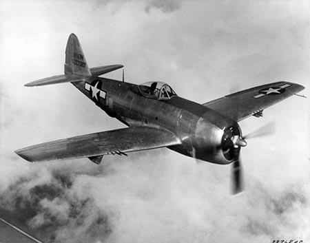
(Image courtesy of the US Air Force)
July and August, 1944 - Aerial back-up for advancing troops after D-Day
B-26 Marauder bombers, flown by the 323rd Bomber Group (9th US Air Force), from the second half of July used the airfield as a base from which to attack the German front line, and to provide aerial back-up for troops moving inland from the beachheads and continuing on through France and into Germany. In late August, 1944, they left Beaulieu for a new base at Lessay in France.
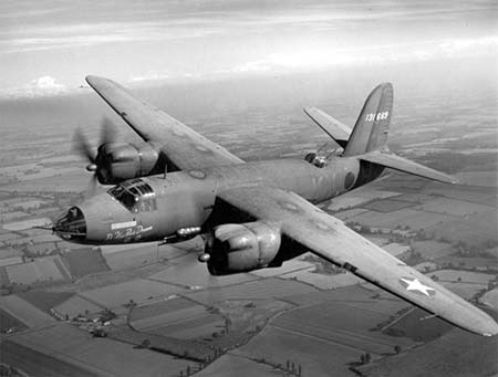
(Image courtesy of the US Air Force)
Late 1944 to September, 1950 - Airborne Forces Experimental Establishment
The Airborne Forces Experimental Establishment (AFEE) were present at Beaulieu during this period, testing gliders, glider tugs, helicopters and parachute equipment, and undertaking very limited pilot training.
Subsequently, although never called into action, the airfield was repaired and retained in part as a U.S. Air Force stand-by site before being returned to the Forestry Commission in 1959.
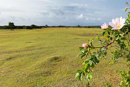
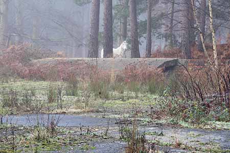
Visiting the airfield - a look at evidence of the airfield on the ground
Beaulieu Airfield is a fascinating place to visit for those who enjoy investigating the past, searching out and interpreting evidence hidden beneath gorse bushes and growths of heather, or else protruding through the turf. Only a small number of structures remain standing: most were sold off and removed, or simply dismantled.
Virtually all the complex is accessible on open heathland and within woodland, although some elements are now on private land - for example, the Handcraft Huts at Dilton and the WAAF air raid shelters.
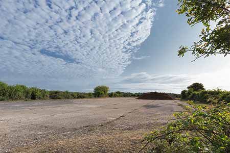
(3) Runways, taxi-tracks and dispersal pans
The original concrete skimmed with tarmac was almost wholly removed in the 1990s for use in road construction projects although in places narrow strips can still be seen.
The sole remaining substantial length of runway, together with an adjacent area of concrete set down in the early 1950s during the airfield's 'stand-by' years, is currently used for flying model aircraft.
Still clearly visible as a series of wide, ghostly, corridors of short-cropped turf, the runway outlines are, however, reasonably clearly visible on the ground, mostly lying a little below the level of the surrounding land.
The main runway - the cross-piece of the 'A' - was bordered on both sides by lights, and so, to a lesser extent, were the subsidiary runways, but except for occasional concrete surrounds, none survive.
The surrounding taxi-track, now somewhat narrower than in war-time, is used in part as a cycle track. Evidence of dispersal pans - places around the perimeter of the airfield set aside for standing aircraft - has largely disappeared, although scattered gravel and occasional concrete fragments hint at former use. But the pan-shaped outlines of multiple dispersal pans show particularly clearly on RAF Museum airfield location plan.
Accommodation sites
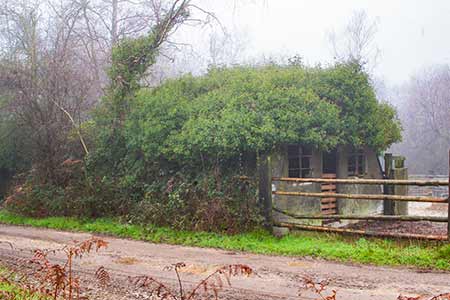
In the area now largely taken by Roundhill campsite, bumps, hollows, bricks, concrete, an old water tower and four derelict, ivy-clad Handcraft Huts betray the location of the airfield's accommodation quarters.
(Handcraft Huts were manufactured from 1942 by the Universal Asbestos Company for use as airfield accommodation. They were quick and easy to assemble on site with good weather proof characteristics).
Known by site numbers, five sites are shown on the accompanying map, whilst Site number 6 was a little to the north-west of Site number 2, beside the modern day entrance to the campsite.
The two nearby Communal Sites housed, for example, Officers' and Sergeants' Messes, a Post Office, Dining Rooms, a Ration Store, Grocery and Local Produce Stores, a Squash Court and Gymnasium.
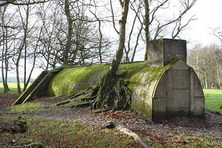
Members of the Women's Auxiliary Air Force (WAAF) were billeted a little to the south, with their own communal area, where today brick and concrete building bases and two old air raid shelters stand incongruously on the edge of a field. (Other similar shelters around the airfield were removed many years ago).
Sick quarters
The Sick Quarters were located a little to the north-east of Site Number 2 and, in addition to facilities for the sick and injured, featured an ambulance garage and mortuary, an air raid shelter and fuel store.
(4) Hangars and workshops
A large expanse of concrete to this day marks the site of a hangar latterly used by Airborne Forces Experimental Establishment (AFEE) 'B' Flight to house Sikorsky R4 and R6 helicopters; whilst a little to the west, across the adjacent service road, were workshops, and buildings used by Airborne Forces Experimental Establishment (AFEE) 'C' Flight, the Paratroop Section responsible for testing parachutes, associated planes and equipment. Here, narrow concrete and once-gravelled paths remain, and so do wider, now grassy access roads and an inconspicuous patch of concrete and gravel half-hidden by encroaching vegetation.
Airborne Forces Experimental Establishment (AFEE) 'A' Flight, users of Horsar gliders capable of carrying 28 - 30 men, or a jeep and gun; and Hamilcar gliders that could transport a tank, had hanger space close to the southern section of the taxi-track.
Bomb storage and preparation area
First planted in 1870, Hawkhill Inclosure, a little to the north of the airfield runways, was used as a bomb storage and preparation site, whilst the service road leading from the modern day car park towards the airfield, and the nearby cycle track, was a means of transporting the deadly cargoes to the waiting aircraft.
Evidence amongst the trees of war-time usage is not difficult to find. For example, go through the gate at the northern end of the car park, enter the woodland, proceed along the right-hand track, and on the right after a short distance is a concrete base, the remains of a long-forgotten small pyrotechnics store where Berry Pistol cartridges were held that when fired, produced flares used for signalling aircraft; and smoke generators used by AFEE 'C' Flight to establish extent and direction of wind drift.
Then continue straight ahead, go over the first crossroads, and after the concrete track bends left into a clearing, another building base or hard-standing can be found on the right, close to a long, low, brick wall, a preparation area where fuses and tail sections were installed, and loading platform that has at one end what appears to be a small concrete shelter.
Airfield defence
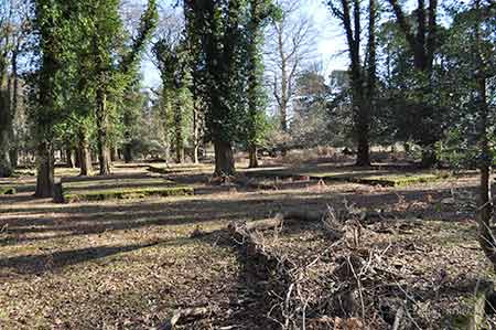
Personnel present to defend the airfield were based on the edge of Stockley Inclosure where a quite extensive complex of brick and concrete building bases engulfed in moss and leaves lies clustered beneath original planting 1809 oaks. Present there were two separate sergeants' quarters, twelve barrack huts and latrines, an ablutions hut and a stores building.
(Image courtesy of NFNPA Archaeology under CC License).
(5) Bronze Age barrows - collateral damage
During construction of the airfield, a number of Bronze Age barrows - centuries-old burial mounds - members of a fairly widely spaced 'round barrow cemetery', were destroyed.
Comparing the modern Ordnance Survey map to the 1871, 6" to the mile Ordnance Survey map suggests three barrows were destroyed, although Richardson, King and Driver show considerably more than are now present on their late-18th century map of the area, and English Heritage suggest that most of the barrows previously present were destroyed.
But despite the urgency of the airfield construction work, a little time was allowed for at least some archaeological excavation before the barrows were flattened. An extract of a report of the excavations on Beaulieu Heath and ahead of the construction of Stoney Cross Airfield follows:
'The excavations to be described were carried out in the autumn and winter of 1941-42, and a total of fifteen barrows were examined. Of these, ten were on Beaulieu Heath, to the south of the Brockenhurst-Hatchet Gate road, and the remaining five near Stoney Cross to the north-west of the New Forest. All the barrows were about to be destroyed in the course of building operations, and it was due to the urgency of the situation that none of the barrows could be more fully excavated. The time of year, and, in the case of Beaulieu Heath, the lowness of the site, made the undertaking in wet weather at least, an extremely difficult one. It is therefore with full knowledge of its incompleteness that I must present this report. Six men were employed at both sites, with Mr Rogers as foreman'.
Other barrows, however, remained unscathed by airport construction and are shown on the map included here as tumuli (multiple barrows) or tumulus (a single barrow).
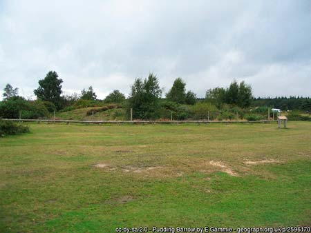
(6) The Pudding Barrow and Cold Pixie's Cave
A surviving barrow, close to the edge of Roundhill Campsite, is of sufficient significance, possibly due to its imposing size, to have warranted a name: Pudding Barrow, echoing the shape of the mound that, as with virtually all others, reminds of an upturned pudding.
This barrow dates from the early Bronze Age, 2,000 years, or so, before the Romans invaded Britain, and is described by English Heritage as an example of a ditched bowl barrow. It is a Scheduled Ancient Monument that is considered to be of national importance, and as such, is protected by law.
It is shown, along with its name, on the 1871 Ordnance Survey map, but a better indicator of the historic use of the name was provided almost 200 years earlier by Richardson, King and Driver who included the name on their map along with the names of other nearby barrows - 'Watts's Parlor', 'Three Barrows', 'Laurences barrow' and 'Coldpix's Cave' (sic).
Cold Pixie's Cave, a bowl barrow, lies beside the B3055 Brockenhurst to Beaulieu road, close to the entrance to Hawkhill Inclosure. It is 29 metres in diameter and 1.7 metres high. English Heritage note that the barrow mound was partially excavated during the winter of l941-42 - presumably as one of the ten excavated on Beaulieu Heath ahead of the airfield's construction, although this barrow did, in fact, survive. The only find of note was an amber necklace.
Despite a covering of vegetation, the mound, although much eroded, remains a fairly conspicuous but not hugely obvious feature of the landscape. Image, though, how it must have looked when first raised, far higher and wider than its current bulk suggests and visible for miles around over the surrounding landscape - remember, Hawkhill Inclosure was only created in around 1870 and prior to that the now wooded terrain was a mixture of open heathland and moorland with no more than scattered trees.
Vegetation-shrouded hollows formed where earth has been crudely torn from the mound, scar this barrow's once-sacred surface, whilst what are probably spoil heaps provide homes for myriad rabbits - these are all tell-tale signs of excavation, probably by a combination of Victorian and other treasure seekers, amateur archaeologists, and the more expert folk who worked in 1941-42.
This barrow is scheduled under the Ancient Monuments and Archaeological Areas Act 1979 and is considered to be of national importance.
(Superstitious country people centuries ago were ready to believe that pixies roamed the New Forest, often with ill intent. Cold Pixie's Cave is certainly an unusual name and it has been suggested that it was originally Colt Pixie's Cave, recalling a mythical New Forest creature that would take on the form of a horse and lead commoners' ponies into the wettest, most dangerous bogs).
Acknowledgements and references:
Special thanks go to the late Alan Brown for sharing his knowledge of the old airfield during conversation and also for providing a wealth of information contained in his two books - 'Twelve Airfields' and 'They flew from the Forest'
Historic England
The Faery Folkloreist
Proceedings of the Prehistoric Society
Quick links
More links
Other related links
Search this site