

Hatchet Mill - a brief history
Hatchet Mill, tucked away on private land, barely visible from public roads, is little known; whilst nearby Hatchet Pond is one of the New Forest's most striking landscape features. Yet the history of both is inextricably linked.
Both are within the bounds of East Boldre parish, although both are also only one and a quarter miles (2 kilometres) from Beaulieu village centre.
Indeed, many people associate Hatchet Pond with Beaulieu rather than East Boldre, which is hardly surprising as the nearby heathland to the south-west is known as Beaulieu Heath. Furthermore, motorists travelling from Beaulieu to Brockenhurst, and Beaulieu to Lymington, pass close to Hatchet Pond, albeit just outside the Beaulieu parish boundary, whilst the houses of East Boldre, to the south-east, often go unnoticed.
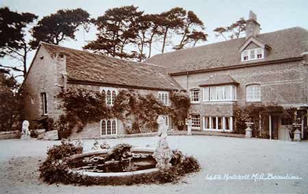
Even period postcards, such as those published by E.A. Sweetman and Sons (shown here), referred to Hatchet Mill, Beaulieu.
History also contrived to add to the confusion, for the village of East Boldre until 1839 was known as Beaulieu Rails - it originated as a 'squatter settlement' created by unauthorised, often 18th century, encroachments on land belonging to the Crown beside the Beaulieu parish / Beaulieu estate boundary bank (which was topped by wooden railings).
(1) Hatchet Pond and Hatchet Mill - their origins
Before considering Hatchet Mill in detail, let's first take a look at the origins of Hatchet Pond and its relationship to Hatchet Mill.
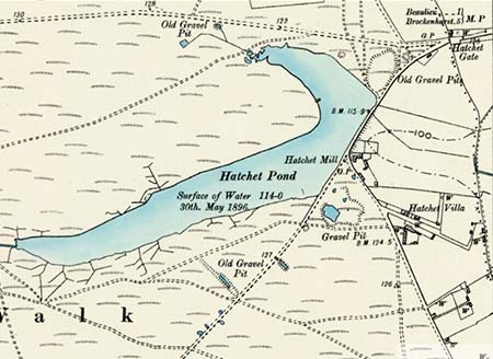
Hatchet Pond was created around 200 years ago when a causeway was built to dam the Hatchet Stream, flood previously present marl pits and in the process, provide power to drive the wheels of Hatchet Mill, a corn mill located across the causeway. (The causeway now carries the B3054, Beaulieu to Lymington road).
The pond is not shown on the map below which, although published in 1814, was originally surveyed in 1787 - a little before the pond was created. The marl pits are clearly marked as 'Old Marl Pits' - maybe even then they were disused - but if the map is to be believed, they do not take up very much of the site of the later pond.
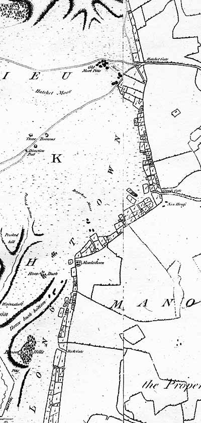
The position of the tracks shown has hardly changed at all to this day, although most now, of course, are roads. But surprisingly, no track is marked leading to the north / south aligned Beaulieu Rails encroachments - the parcels of land shown on the map with an 'i' denoting 'incroachment': an alternative, somewhat old-fashioned name for an encroachment.
Beaulieu Rails, however, is not mentioned at all on the map, but instead the settlements from Hatchet Gate right the way down to East End are referred to as 'Long Town'. (Even today, East Boldre Parish Council notes that: 'East Boldre Parish is one of the most unusual Parishes in the New Forest with one main road running from Hatchet Pond to East End, some two and a half miles'. Long Town, then, was a very appropriate name back then and now, but a name that did not pass the test of time).
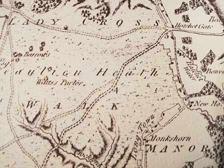
It is, then, fairly safe to say that Hatchet Pond did not exist in 1787 unless the map-makers were guilty of a glaring omission. Nor does the pond appear on Thomas Milne's 'Map of Hampshire and the Isle of Wight' (below), published in December 1791 but surveyed 'in the years 1788, 89 and 90'.
However, creation of the pond seemingly came shortly after completion of the surveys for these maps. Local historian Jude James (East Boldre: A New Forest Squatters Settlement 1700 - 1900) suggests that the dam was built in around 1790 and notes that 'in 1801 the mill and fields were owned by Charles Kearley'; whilst Richard Reeves, another noted New Forest historian, points out that the pond was certainly present by 1797 when the area was surveyed for Ordnance Survey mapping purposes.
Nor is Hatchet Mill shown on these early maps, simply because it did not exist before the pond was created - Richard Reeves again points out that there was no reference to the mill in the 1787 survey, the lands then being in the occupation of Nicholas Kearley - the father of Charles Kearley?
(The mill building, according to East Boldre Parish Council, 'is believed to have been built in the 18th century' - presumably the late 18th century, coinciding with the construction of the causeway and creation of the pond).
But could a large pond be created and a causeway built on Crown Land, to power a privately owned mill, without authority from the Crown?
To answer that question, I'm again indebted to Richard Reeves for the following: 'The creation of the pond would be considered a purpresture (an encroachment), so technically permission would be needed, but was apparently not sought. But the pond was not noted as an encroachment by the Encroachments Inquiry of 1801 as no one claimed ownership of it. However, in 1826 the Forest officers attended an 'official fishing' so as to claim the rights of fishing for the Crown'.
Gravel extraction
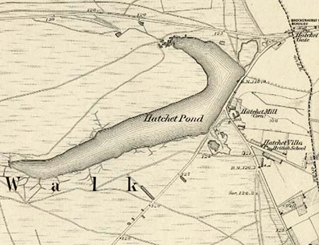
The area in the vicinity of Hatchet Pond, as well as providing marl to fertilise the fields, has also provided a rich source of gravel. The 1898 Ordnance Survey map clearly shows the location of gravel pits, including one that was subsequently used as part of the current Hatchet Pond car park - on the 1898 map it was marked as 'old' suggesting that even then it was disused.
But gravel continued to be extracted locally until at least the 1940s as it's thought that Little Hatchet Pond and its neighbour, both alongside today's Hatchet Moor car park, were excavated to provide gravel needed during the construction of the nearby Second World War airfield.
(2) Hatchet Mill
So, in 1801 the mill and fields were owned by Charles Kearley, perhaps the same Charles Kearley who died on 27th May, 1842 and was buried in a small, now defunct graveyard close to an equally defunct Methodist chapel in East Boldre's Massey Lane.
Victorian and later directories provide information about the mill and its millers, although in many cases the details are fairly limited. The Post Office Directory, published by Kelly and Co in 1855, for example, mentions 'Hatchet Mill and Swinsley, 1 mile south-west of Beaulieu' - Swinsley is recalled by the current day Swinesleys Farm, a little to the south-east of Hatchet Gate - but does not provide anything further.
William White's 1859 directory is, however, a little more forthcoming and has the following entry: 'Hatchett (sic) Pond, which covers about 30 acres, abounds with fish, and supplies a stream which turns the large over-shot wheel of Hatchett Mill.......', and lists under Corn Millers, 'Biddlecombe Benjamin, Hatchett Mill'.
Meanwhile, J.G.Harrod's 1865 directory again lists Benjamin Biddlecombe, but simply as a farmer of Hatchet Mill; whilst in the Post Office directory of 1875, again published by Kelly and Co, and in Kelly's own directory of 1880, Mrs Ann Biddlecombe is shown as the farmer and miller.
By the time of Kelly's 1889 Directory, Jas Biddlecombe is listed as the miller, and the mill as a steam and water mill.
(Agriculture prospered for much of the second half of the 19th century and many mills were modernised. Steam engines were typically first installed to increase the water flow to the mill wheel, and eventually to directly drive the mill shafts. Supplementing water power in this way was particularly appropriate for mills where water alone was often inadequate as a result of, for example, droughts and consequent low water levels, and freezing conditions locking in the water).
Hatchet Mill is mentioned again in the 1898 Kelly's directory, by which time Samuel Suffield Biddlecombe is the miller, and the mill is again listed as a steam and water mill.
The winds of change
But in Kelly's 1911 directory, Charles Carey-Wood of Hatchett Mill is listed only as a private resident - there is no reference to milling although the 1909 Ordnance Survey map continues to show the mill.
(In the early 20th century, and sometimes a little before then, many rural corn mills closed or converted to producing animal feeds - competition from cheaper imported grain processed in huge, often coastal, highly efficient water turbine or steam powered flour mills was a major factor in their demise).
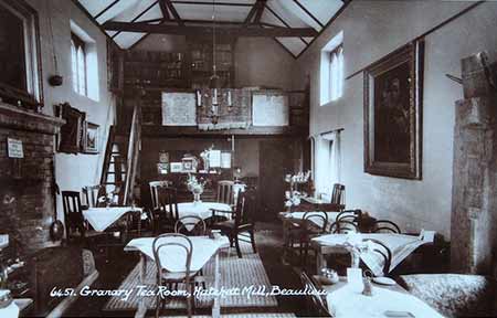
Subsequently, for at least part of the period between the two World Wars, and for a time after the Second World War, the Granary Tea Room operated from the mill complex and were immortalised in a series of contemporary postcards published by E. A. Sweetman and Sons of Tunbridge Wells.
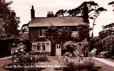
In more recent times, a 1978 publication by the Southampton University Industrial Archaeology Group stated that all the mill machinery had been removed and the mill and mill house converted to a private house.
East Boldre Parish Council, meanwhile, currently (2020) note that: 'There are no really large houses in East Boldre with the exception of Hatchet Mill which is believed to have been built in the 18th century. The building had become almost derelict but was rescued and restored by the present owners'.
Hatchet Mill is not open to the public, and is not easily visible from the road.
References:
Thanks are due to Richard Reeves for providing information about the pond and mill
Water and Wind Mills in Hampshire and the Isle of Wight: Southampton University Industrial Archaeology Group
Hatchet Pond - Forestry England
East Boldre Parish Council
Quick links
More links
Other related links
Search this site