

A New Forest walk near Stoney Cross and Fritham
Featuring:
Stoney Cross Airfield, Janesmoor Pond, Cadman's Pool, Ocknell Pond, North Bentley, South Bentley and Ocknell Inclosures, Anses Wood and wildlife-rich heathlands.
Overview
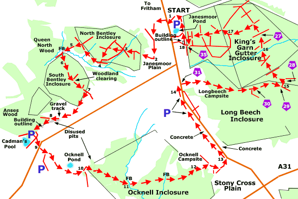
This 6¼ mile (10 kilometres) walk crosses largely level ground with few significant gradients. The route starts in the Janesmoor, Forestry England car park a little to the south-east of Fritham.
Much of the way is across the heathland site of the Second World War, Stoney Cross Airfield, although ancient, unenclosed woodland and a number of woodland inclosures provide considerable added variety.
Those who wish to restrict the walk to the old airfield site or simply want to shorten the route can, however, readily miss out some of the woodlands; whilst there are many opportunities to stray from the route and further explore the airfield site.
Wildlife watch
Heathers, gorse, bracken, invading birch, and ancient, once-coppiced hollies will all be encountered on the New Forest heathlands. Look out, too, for tiny Dartford warblers, noisy stonechats, relatively inconspicuous woodlarks and many other wild birds.
The broad-leaved woodland inclosures and coniferous inclosures, meanwhile, offer their own special beauty and wildlife; and so, of course, do the ancient, unenclosed woodlands.
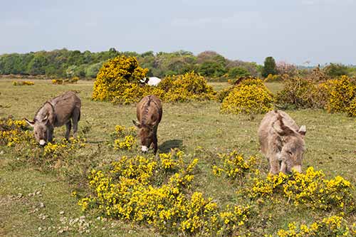
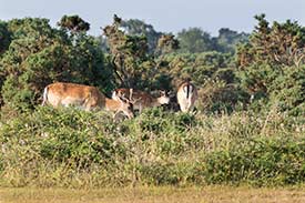
Fallow deer and roe deer are likely to be present just about anywhere along the walk route, even close to the campsites, whilst a range of wild flowers, birds, butterflies, fungi, dragonflies and damselflies will often add further wildlife interest to the walk.
A bit of history
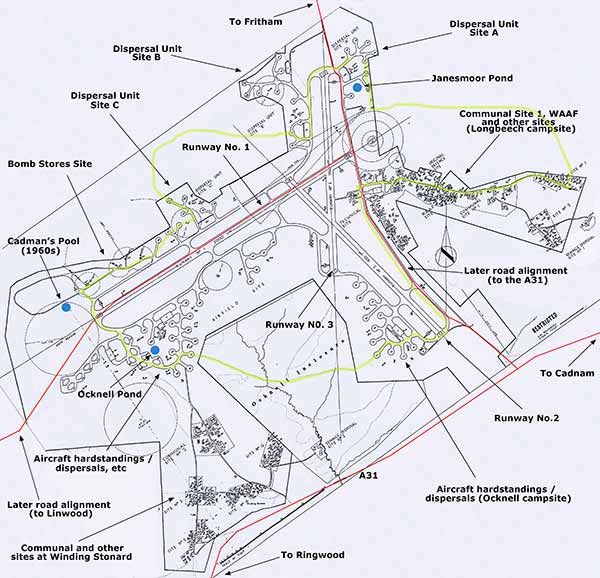
Stoney Cross Airfield, also known as RAF Stoney Cross, was constructed on Ocknell and Stoney Cross Plains, close to the tiny New Forest hamlets of Stoney Cross and Fritham.
Building activity started early in 1942 and the site was handed over for operational use in November of that year, although it was not ready to accommodate aircraft until January, 1943. It was the last of the three major New Forest, Second World War airfields to be completed - the other two, Beaulieu and Holmsley South, were ready for use in August and October, 1942, respectively. The land on which the airfield had been built was handed back to the Forestry Commission in 1956.
There's lots more information here about Stoney Cross Airfield - its wartime role and Stoney Cross Airfield - its detailed layout.
(Note - the detailed layout of the airfield opens in a new window so that the large scale plans that it contains and the walk route details can be viewed side-by-side. Similarly, and for the same reason, the links provided in the route text also open in a new window).
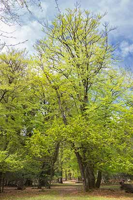
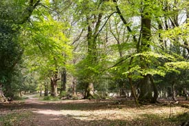
Woodlands along the route include marvellous ancient, unenclosed woodlands, and also a number of inclosures - North Bentley, South Bentley, Ocknell, Long Beech and King's Garn Gutter Inclosure. Look out for ancient oak and beech trees bedecked with ferns, an abundance of woodland birds and a baffling range of lichens, stunning autumnal colours and a huge variety of fungi.
Context is provided, however, by considering the long history of these woods. North Bentley Inclosure, for example, was created way back in 1700 to provide a source of timber for the construction of Royal Navy warships, although it was largely converted to conifers in the 1930s. Nearby South Bentley Inclosure was also created in 1700 and planted with acorns - this inclosure is said to be the oldest surviving plantation in the New Forest and, indeed, the oldest planted oak wood in the country, although around one third of the old oaks were replaced by conifers in the 1960s.
Ocknell and Long Beech Inclosures both date back to 1775 and feature many beautiful old oak and beech trees, whilst King's Garn Gutter Inclosure is a relative newcomer - it was created in 1860 and still features some original oak and beech along with later plantings of broadleaves and conifers.
Further historical background information about the New Forest's woodland inclosures is here - New Forest Inclosures.
6¼ miles (10 kilometres).
Start:
Janesmoor Pond, Forestry England car park.
Terrain:
Largely on level, firm ground with few significant gradients.
Refreshments:
Sorry, there are no pubs or tea rooms along the walk route but the Royal Oak at nearby Fritham is well worth a visit.
New Forest Tour bus route:
No.
(Crown Copyright, RAF Museum)
Parking
The walk starts from the Janesmoor Pond car park, although alternative parking is available beside Cadman's Pool, close to Ocknell Pond and alongside the minor road close to Longbeech campsite.
Walk route directions
1. Follow the wide gravel track that leaves the Janesmoor Pond car park by its northern entrance - the pond will be on the left when facing out of the car park.
(This track and the Janesmoor Pond parking areas were the location of the old airfield's 'Dispersal Unit Site A'. A look at Google Maps satellite view will reveal the locations of the dispersal pans / aircraft hardstandings (numbered 165 - 169 on the site plan) and blister hangars (numbered 125 and 125A).
Perhaps surprisingly, Janesmoor Pond remained seemingly untouched during wartime, and maybe was an oasis of calm in the midst of the intense activity).
Turn right, onto the tarmaced public road and immediately go left, past a low Forestry England vehicle barrier, and on along an old airfield taxi-track consisting of gravel overlaid in places upon sections of concrete and tarmac in varying states of disrepair.
(The left turn off the tarmaced public road (at 19 on the site plan) passes close to the northern end of Runway number 3, a 1,366 yards long north-south aligned runway, which here is a little to the left of the walk route. The course of this runway goes parallel to the modern road virtually right the way down to Ocknell campsite.
The runway outlines are typically at a slightly lower level than the adjacent land as at least some soil was stripped off when the runway surface was removed; they are often bordered on both sides by lines of brambles and gorse; they are (needless to say) absolutely straight; and their grass is often of a lighter shade to that of adjacent land, with patches of gravel, occasional bricks and pieces of concrete showing through).
Follow this track round to the left and then continue straight ahead, ignoring a right turn leading along a wide gravel track which, too, in places has broken concrete present.
(This right turn led to the northern section of the airfield's 'Dispersal Unit Site B'. The Google Maps satellite view reveals feint traces of the location of some of the aircraft dispersal pans / hardstandings, for example, that near this junction, labelled number 159 on the site plan).
2. Those who wish to avoid the walk through North and South Bentley Inclosures - the first woodland sections of the walk - should continue straight ahead at the end of what is now a tarmac track and re-join the main route at the beginning of section 7.
Otherwise, at the end of the tarmac track, go 90 degrees right, along a wide concrete track and after a short distance, follow this as it goes round a little to the right.
(This led to aircraft hardstandings number 156, which was to the left, and number 157 to the right).
When the concrete ends - at the site of aircraft hardstanding number 157 - continue for a short distance along a dirt track that bears a little to the left and pass through a gate to enter North Bentley Inclosure.
Follow the grassy / dirt track into the woodland as the track bears first a little to the right and then to the left, and continue along this main track as it eventually goes downhill.
3. At the bottom of the hill, reach a staggered six-way junction of tracks. Ignore here the first wide track on the left, going back uphill; go right for a very short distance; ignore a fairly narrow path on the right and another on the left; and take the left-most of the two remaining tracks - in effect, this is straight on, albeit through a multi-track junction.
Continue uphill, after a short distance follow the track as it bears a little to the right and quite soon after, at the top of the hill, go left, downhill, at a 'T' junction.
Almost immediately pass a very wide grassy ride on the right and continue downhill along what now is a gravel / grassy track. Eventually pass a grassy ride on the left and immediately after, leave the inclosure through a gate.
4. Immediately turn right alongside the inclosure fence to follow a fairly narrow dirt track that in places goes through, and in other places passes alongside, a wonderful ribbon of ancient, unenclosed woodland where holly groves and aged oak and beech trees hint at how things were before the inclosure was created.
Follow the path across a small, damp grassy clearing where to the left, numerous grassy hummocks are clearly visible.
(Hummocks such as these can be seen on many New Forest grasslands. Some are intensely grazed, purple moor grass tussocks, although recent research by Richard Reeves suggests that many are ant hills, yellow meadow ant nests originally created in relatively dry grassland but subsequently abandoned at sites that later became too wet for the ants to prosper).
Re-enter the ancient, unenclosed woodland and after a relatively short distance, reach a gate on the right through which a track goes back into the inclosure. Go left here along a narrow, fairly obscured path leading a little downhill - ignore the main inclosure-edge path here as it continues straight ahead.
5. Cross another small, grassy clearing, keeping to its right-hand edge (alongside ancient, unenclosed woodland on the right) and go over a narrow, meandering stream which is easily stepped across in dry weather (but maybe not after heavy rain).
Continue straight ahead along a quite wide, but not particularly pronounced, muddy / grassy track, with the South Bentley Inclosure wood-bank and fence immediately to the left.
After a short distance, cross the course of a drainage channel - dry in summer - and enter the inclosure through a gate on the left.
(To the right of the path here can be seen aged hollies beneath magnificent, original 1700 planting oaks and mature beech trees, which provide a landscape of similar character to the New Forest's ancient, unenclosed woodlands).
6. Continue straight ahead, uphill, but note that in July 2018, although the way ahead was readily passable, a sign advised that this section of the route (up to the start of the next woodland clearing) was temporarily closed to allow the ground to recover following forestry clear-fell work - this was a little odd as the forestry work was to the left of the path and did not touch the walk route.
When almost at the top of the hill, pass a fairly wide track on the left and immediately after, pass through a woodland clearing surfaced with broken concrete sprinkled with gravel.
(This was the location of the blister hangar marked number 121 on the site plan - part of 'Dispersal Unit Site C'. A large patch of stinging nettles located immediately upon reaching the concreted area indicates disturbed ground. When last I visited, large blocks of baled heather were present on the concrete, too, and huge piles of decaying, cut bracken).
Again, continue straight ahead along the wide concrete track, pass on the left a turn which for a short distance is also wide and concrete surfaced - the site of blister hangar number 122. Soon after, leave the inclosure through a gate and go right.
7. Continue parallel to the inclosure fence-line, through a woodland edge ribbon of scattered mature broadleaved trees with in places, a nice holly under-storey.
(The track that leads straight ahead out of the wood is also surfaced in concrete: this formed part of the taxi-track leading to the blister hangars just passed, and also to aircraft hardstanding number 153).
After a relatively short distance, where the inclosure fence goes away to the right, continue straight ahead over open, grassy heathland, in the direction of the left-hand edge of a section of woodland 200 - 300 metres away.
Cross the extremely vague / barely visible outline of a taxi-track that led to aircraft hardstanding number 150; and immediately after, go right, along a gravel track lined with a varied selection of gorse bushes, holly, crab apple, hawthorn, willow and birch trees; and continue downhill.
(This gravel track led to the site of the Bomb Stores Site. The track mysteriously appears as if from nowhere and now leads to nowhere, but originally it was linked to a taxi-track that ran parallel to the nearby 2,000 yards long Runway number 1).
8. When close to the edge of the woodland, take a left-hand fork in the track.
(An old, disused gravel pit on the left along here now in places boasts an attractive array of wetland vegetation including marsh St. John's wort, bog asphodel, cotton grass, sedges, sundews, cross-leaved heath, mosses and grasses. A broken, presumably airfield-related, pipe is also present).
Follow the path into the woodland.
(A little after the wood is entered, 20 - 30 feet, or so, to the left, amongst an ancient holly grove, is a quite small, oval, earthen mound around 2 - 3 feet high into which is set the rectangular outline of a single skinned, brick-built structure perhaps 6 feet long by 2½ feet wide. This was presumably associated with the Bomb Stores Site and could be part of the remains of the Incendiary Bomb Store).
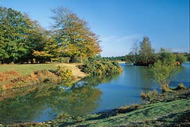
After a short distance, turn left and walk to the nearby tarmaced public road or, alternatively, continue straight ahead to Cadman's Pool - a body of water created in the 1960s on the edge of Anses Wood, a block of beautiful ancient, unenclosed woodland - and then follow the car park approach road back to the tarmaced public road.
(The car park approach road, which remains surfaced with airfield-related concrete, originally linked Runway number 1 with the parallel taxi-track and the Bomb Stores Site).
9. Cross the road and virtually opposite the Cadman's Pool car park entrance, continue straight ahead along a wide gravel track with, in places, concrete showing though.
(This gravel track and the next led to a number of aircraft loop standings and aircraft hardstandings in the area around Ocknell Pond - the outline of many remain visible on the ground and from the air using Google Maps satellite view).
After around 100 metres, take the left-hand fork at a 'Y' junction, past a low, Forestry England vehicle barrier, and again continue straight ahead along this very pronounced track, which still has bits of concrete showing through.
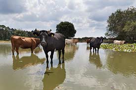
(Ocknell Pond, around 75 metres to the left of the track along here, is popular with commoners' stock - ponies, cattle and donkeys - as a watering hole and place to cool off in hot weather, although from late spring through to early autumn there is frequently little water present).
10. After around 600 metres - immediately after the track bears gently left, immediately before it goes quite sharply right (by the start on the right of a small, dense trackside copse) and immediately before the extensive woodland of Ocknell Inclosure is reached - go left along a now grassed airfield taxi-track.
(Aircraft hardstandings numbers 197 and 198 were located on this corner. The taxi-track to the left led to the sites of aircraft hardstandings numbers 189 - 196 and other nearby reminders of the old airfield, whilst the track that goes sharply right led to Communal Sites 2, 3, 4, 5 and 6, and Sewage Disposal Site number 2 where accommodation and other facilities were situated close to Winding Stonard).
After around 100 metres, follow the Ocknell Inclosure woodland edge round to the right - immediately on the left here is the grassy sunken outline of a keyhole-shaped aircraft hardstanding, whilst to the right is a holly grove through which passes a substantial but eroded inclosure wood-bank and ditch, presumably dating back to creation of the inclosure in 1775.
(Adjacent to this aircraft hardstanding is a clearly visible, long-disused gravel pit in the depths of which nature has reclaimed its own in the form of extensive vegetation and an array of shrubs and trees).
After a further 75 metres, or so, follow a fairly narrow but very pronounced path leading into the mature, broad-leaved woodland of Ocknell Inclosure.
Continue along the path for around a further 400 metres.
11. Cross a quite narrow, valley-bottom stream; immediately pass over a grassy clearing and soon after plunge back into the woodland.
Continue along this main path as, after another 250 metres, it crosses a second narrow stream (this one is quite marshy, rather than gravel-bottomed) and then eventually, after another 250 metres, climb a short, steep bank to emerge onto an area of broken Second World War concrete - aircraft hardstanding number 174 - that now forms part of Ocknell campsite.
(The layout of this and other hardstandings is clearly visible using Google Maps satellite view).
12. Continue straight ahead here and then after a short distance, at a 'T' junction, turn right, still on broken concrete.
(To the left and right at this junction are further still-concreted aircraft hardstandings, all linked via a semi-circular taxi-track and all now used as part of the campsite).
Follow the main campsite approach road as it bears left and then leave the site along what now is a tarmac road - albeit with, in places, concrete showing through - as it first bears right, then at a 'Y' junction, left and soon after, at another 'Y' junction, left again.
Almost immediately, pass on the left the end of one of the airfield runways.
(This is the south-eastern end of the 1,520 yards long Runway number 2).
Follow the campsite approach road as it bears a little to the left, and reach a tarmaced public road.
13. Go left, alongside the road.
(Immediately on the right of the road here is a wide expanse of what is presumably airfield-related concrete, whilst a little further on, on the left, is a narrow strip of similar concrete. Neither is marked on the site plan).
When around 1 kilometre from the campsite approach road, pass on the left the concrete surfaced, Stoney Cross car park and after a further short distance, the Stoney Cross Plain car park, the latter sited on concrete that in the past was used as a hardstanding for transport planes, and where can be found a well-produced airfield interpretation board.
Soon after, pass an area of concrete on the right of the road and a concreted track leading back, parallel to the road - this led to the airfield Sick Quarters and RAF Transmitter Station that were both located close to what is now the A31. Neither is shown on the site plan reproduced here.
14. Those who wish to return straight to the Janesmoor Pond car park without passing through the walk route's last section of woodland should continue straight ahead here and follow the road back to the car park.
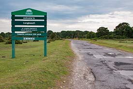
Otherwise, after a further short distance, take the next right turn, which here comprises broken tarmac on top of concrete, at cycle track post number 31 to follow the access road into Longbeech Campsite.
(The airfield Technical Site, what was described as the Original Defence Site, WAAF Site, Communal Site number 1, Site numbers 1 and 2, and the Sewage Disposal Site number 1 were all located in and around the area now taken by Longbeech campsite).
Ignore concrete and other tracks and turns to left and right, and continue along the main access road, eventually downhill past cycle track post number 30 and out of the campsite. Reach the end of the concrete surfaced road - at cycle track post number 29 - and follow what is now a narrower gravel track round to the left.
15. Go through a gate on the left that gives access to King's Garn Gutter Inclosure and immediately pass cycle track post number 28.
Follow the cycle track as it bears round to the left and ignore here a grassy ride on the right. After a further 100 metres, or so, go straight ahead at a cross-roads - to left and right are quite wide grassy / muddy rides running alongside a substantial inclosure wood-bank.
After another 150 metres, at a 5-way junction of tracks, go straight ahead, again along the cycle track - to left and right are grassy / muddy rides.
16. Go over a small stream that flows through a pipe under the track, walk on uphill for a very short distance and go straight ahead where to left and right are not very prominent grassy / overgrown paths.
At the top of the hill, pass cycle track post number 27 and continue straight ahead at another crossroads - to the right is a quite wide gravel track, to the left an equally wide grassy ride. After around 150 metres, leave the cycle track at the next crossroads by turning left along a quite wide, grassy, uphill ride.
17. After around 300 metres, at a 'T' junction, turn right, down hill along a gravel cycle track; and after a further 100 metres, where the cycle track goes sharply right, still downhill, turn left uphill to go through a pedestrian gate and on along a narrow gravel / dirt track / path.
Continue straight ahead; after a short distance, pass a grassy ride on the right and then another on the left; and again continue straight ahead, uphill, before after another 100 metres, going straight ahead at a crossroads - there is a gravel track to left and right here.
At the top of the hill, at a junction with a wide, grassy ride, continue straight ahead along a minor path that initially, in summer and autumn, is shrouded in bracken, and then after a further 50 metres, go left at a 'T' junction along a grassy path bordered by telephone poles.
After 100 metres, turn right along a gravel cycle track - at cycle track post number 35 - and immediately after, leave the inclosure to reach the open heathland near Janesmoor Pond.
18. Turn right, past after a very short distance a brick, stone and concrete outline in the grass that marks the location of an airfield building described on the site plan as a 'General Purpose Hut'; and continue broadly parallel with the inclosure fence-line to return to the start point car park.
Quick links
More links
Search this site