

New Forest Walks - Walks from Lyndhurst
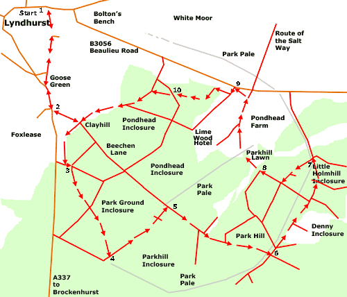
This walk passes along Beechen Lane and through Park Ground Inclosure, Park Hill, and Denny, Little Holmhill and Pondhead Inclosures.
Overview
After leaving Lyndhurst village, the walk route for a short distance follows Beechen Lane, an ancient track-way once used by travellers journeying between Lyndhurst and Denny Lodge.
A right turn enters the broad-leaved woodlands of Park Ground Inclosure, first planted in 1810, and eventually continues through a narrow strip of ancient, unenclosed woodland, which is the drift-way between Park Ground and Parkhill Inclosures.
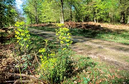
Beechen Lane is re-joined, and nearby is more ancient, unenclosed woodland that has in its midst an old, quite extensive area of fairly shallow, man-made pits. Exact age is uncertain, and so is the material extracted. Maybe it was marl, a lime-rich substance used to enrich the land in the days before modern fertilisers were introduced. Or maybe it was clay, a valuable brick-making resource that can be found in a number of places on this side of Lyndhurst. Evidence of surface gravel, however, strongly suggests that this is actually an old gravel pit.
Notice here also, the Park Pale, a prominent earthen bank and ditch that surrounded the medieval deer park known latterly as Lyndhurst Old Park. The bank and ditch date back to at least the 13th century.
The route continues through the coniferous inclosure woodland of Denny Inclosure and the broad-leaved inclosure woodland of Little Holmhill - holm in the New Forest means holly. Both these woodlands are relatively young - they were first inclosed in 1829 and 1870, respectively.
The Salt Way is crossed twice, and followed for a short distance. A track once used by men carrying salt inland from coastal salterns, much of the Salt Way has been destroyed by later inclosure planting, but in places continues in use by walkers and others.
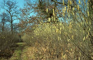
Return is over Parkhill Lawn, past Pondhead Farm and on through Pondhead Inclosure. Previously known as Mine House Grounds, Pondhead Inclosure was first planted in 1810. Many of the original oaks and beeches remain, together with occasional sweet chestnuts and other trees.
Pondhead is unusual amongst New Forest woodlands as, for more than 30 years, stock-proof and deer-proof fencing has helped keep grazing and browsing pressure at bay. As a result, a rich under-storey has developed, wild flowers are abundant and a wide variety of spring and summer butterflies can be seen. In recent years, rotational hazel coppicing has also resumed, which further encourages wildlife interest.
Roe deer and fallow deer are present in good numbers throughout the walk area. Foxes, too, particularly in winter and when with young to feed, hunt in daylight along the woodland rides, whilst buzzards frequently soar above the trees, mewing loudly. Hawfinches can occasionally be seen, and so too can a wide range of other, more common woodland birds.
9 kilometres (5½ miles).
Start:
Lyndhurst village centre.
Terrain:
Mainly on level ground, but with a small number of gentle gradients; and mostly firm, but as sections can at times be wet and muddy, strong boots are recommended.
Refreshments:
The Crown Stirrup is on the walk route. Other pubs in Lyndhurst include The Fox and Hounds, The Stag, The Mailmans Arms and The Waterloo Arms. The Crown Hotel, too, serves food and drinks, and there are also numerous tearooms, cafes and restaurants.
New Forest Tour bus route:
Yes - summer only.
Parking
There is a large 'Pay and Display' car park in the centre of Lyndhurst.
Walk route directions
1. Leave the village centre and walk south along Gosport Lane until Goose Green is reached. Take the left fork towards Brockenhurst, and beside Foxlease Bridge, pass the site of the now-demolished turnpike cottage.
Turn left opposite the entrance to Foxlease, the Girlguiding UK Training and Activity Centre.
2. Pass immediately on the right the old thatched Glenber Cottage, and continue straight ahead along Beechen Lane until the woodlands at Clayhill are reached.
Immediately before the wide Forestry England vehicle gate across the gravel track leading straight ahead, turn right through the smaller, pedestrian gate to take the path around the edge of Park Ground Inclosure. Follow this as it swings left, pass the garden of the Crown Stirrup inn - a good place, maybe, for early refreshments - and continue on past the rear of a number of cottage gardens until a grassy 'T' junction is reached.
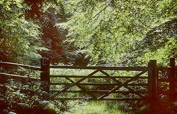
3. Turn left here, and then immediately right beside the New Forest keeper's wood shed. Follow this track as it bends round to the left, go straight ahead at the next cross-road of tracks, and eventually leave the inclosure through a gate leading to a strip of unenclosed woodland.
4. Turn left here to follow the drift-way between Park Ground Inclosure and Parkhill Inclosure.
Reach a gravel track – this is Beechen Lane again – and turn right.
(The Salt Way followed the drift-way as it continues on between Pondhead Inclosure and the ancient, unenclosed woodlands of Park Hill. Notice here also the rounded, badly eroded earthen bank running at right-angles to the lane - this is the Park Pale that once enclosed Lyndhurst Old Park. Its equally eroded bank and silted ditch are also visible across the drift-way at the start of Section 4).
5. Continue up a gentle incline with Parkhill Inclosure on the right, and ancient, unenclosed woodland on the left. A slight detour here will reveal the area of man-made pits - marl, clay or gravel diggings - referred to earlier. Follow the lane until a 'T' junction is reached, with, ahead, a narrow stretch of heathland.
6. Turn left at this junction, go through a gate and continue down the track through the coniferous woodland of Denny Inclosure. Pass a turn on the right and, behind a narrow screen of conifers, an area of re-generating clear-fell. Reach the broad-leaved trees of Little Holmhill Inclosure, ignore turns to left and right, and follow the path straight on into this woodland. Go down a gentle incline and through a gate.
7. Turn left immediately after the gate, and follow the path beside the inclosure fence.
(Notice along here the ‘creeps’ created by deer that pass below the fence. To the right, running parallel with the path, hidden amongst the trees, is a small stream flanked by alders, many of which have in the past been coppiced. This stream has at some time been straightened and deepened to reduce the risk of flooding).
Go through a gate, turn right along a grassy track and continue straight ahead until a further gate is reached giving access to Parkhill Lawn, an area of heath and grassland.
8. Go through the gate and continue straight on across the lawn, following a wide, grassy ride skirting on the left the ancient, unenclosed woodland of Park Hill. Follow the ride as it bends right, towards a small bridge across a narrow stream. Cross the bridge and continue straight ahead over the lawn.
(Pondhead Farm is on the right, and across the fields to the left is the relatively recently rebuilt and extended Lime Wood hotel - on the site of the old Parkhill Hotel).
Eventually join and follow a wider track – this again is on the route of the old Salt Way. Continue straight ahead, after a short distance pass on the right a red-brick cottage, cross a small bridge over a stream and follow the now gravel track as it bends left for a short distance to reach the Beaulieu Road.
9. Turn left for a very short distance, along the drive leading to Lime Wood, but go right just before entering the hotel grounds. Follow the path through a patch of bracken, and go through the first gate on the left into Pondhead Inclosure.
Continue along this grassy ride, and cross a bridge over a small stream.
(Notice here how invasive rhododendrons have been cleared from the woodland floor – the flowers make a fine show but the plants are of little use to wildlife, and shade out other species).
Follow the path as it bends round to the right.
(Notice in this part of the wood the stands of coppiced hazel of varying ages).
10. Reach a staggered crossroad of tracks under the spreading boughs of a giant sweet chestnut tree. Turn right then immediately left to follow a narrow path through the coppice. Reach a gravel track and turn left.
Pass another quite wide track on the left, and continue on until Beechen Lane is again reached, and with it, the earlier start of the woodland part of the walk route. From there, retrace your steps back to the village centre.
Quick links
More links
Search this site