

Weirs - North and South
North Weirs (A) and South Weirs (B) are 1.5 kilometres (1 mile) west-south-west of Brockenhurst village centre. Vehicular access for residents is available to both, and access is available for pedestrians along the gravel roads and from the open Forest. The track at North Weirs is also a cycle track, whilst a public footpath passes through South Weirs.
But until relatively recently, certainly until after World War Two, it was Brockenhurst Weirs that showed on maps of the area, rather than today’s separate North Weirs and South Weirs.
Both North Weirs and South Weirs are, though, even if not in name, of some antiquity. Richardson, King and Driver on their late-18th century New Forest map show in both places numerous incroachments, that is, land taken illegally from the Forest; whilst Worthys Farm, in South Weirs, is known to have taken its name from 18th century occupiers.
Furthermore, the Reverend Henry Comyn in his 1817 Directory of Life in the Parishes of Boldre and Brockenhurst details the residents of many properties that still stand. Comyn, though, referred to the area as The Wires, a pronunciation that apparently continued into the 20th century.
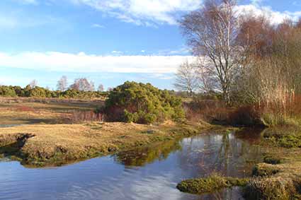
The North and South Weirs names are shared with that of a watercourse – The Weir – that flows close to North Weirs. It joins another small stream from South Weirs; crosses Brookley Road, the village’s main street, at a ford – the Watersplash; and eventually joins the Lymington River a little to the north-west of Brockenhurst Bridge.
Here again, though, names can be confusing. Richardson, King and Driver show it as The Ware; there is a mid-19th century reference to an adjacent lawn known as Weare’s Lawn; and ever since the 1870 1st Edition, 6” to the mile Ordnance Survey map, it’s been The Weir.
Richardson, King and Driver also show Ware Passage, a track linking the two communities, close to or on the same line as the current path and footbridge over The Weir - some things never change, not even after 200 and more years. (They also show the area upstream as The Plain of the Moor, a name that is not often encountered elsewhere).
19th century drainage enthusiasts seem to have been in action on The Weir, and probably in the surrounding area. Josiah Parkes, a contemporary drainage expert and builder of Brockenhurst’s Victoria Brick and Tile Works, promoted the need for change at Weare's Lawn, noting that this morass ‘abuts on the skirts of Brockenhurst, rendering the air most insalubrious, and occasioning constant disease.…‘.
And somebody certainly did get to work. Richardson, King and Driver show The Ware on what was presumably its original, meandering course through an area of bog close to the village, but by the time of the 1870 Ordnance Survey map, The Weir is shown as a perfectly straight channel. And today, the ‘bog’ - Weare's Lawn, maybe - can still be quite wet after rain, but would never be described as a bog.
Today, the varied landscapes of North and South Weirs provide great places for wildlife to live – there are heathlands; bogs; streams overhung and in places overgrown with vegetation; alder carrs; and agricultural lands around the numerous holdings.
References:
Comyn’s New Forest: Jude James
New Forest Notes by Anthony Pasmore - Lymington Times
More links
Other related links
Search this site
Sadly, 58 animals were killed - 35 ponies, 13 cows, 8 donkeys and 2 sheep, whilst a further 32 were injured - 3 pigs, 9 donkeys, 11 cows and 9 ponies.
(Forty-three accidents occurred in daylight, 15 at twilight and 101 in the dark. Twenty-seven accidents were not reported by the driver involved).
Here's just one horrific example - Three donkeys killed in collision with van at notorious New Forest blackspot (Advertiser and Times)