

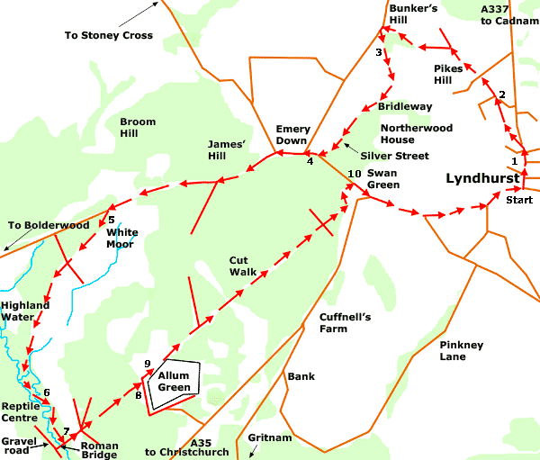
New Forest Walks - Walks from Lyndhurst
This walk features the hamlets of Pikes Hill, Emery Down, Allum Green and Swan Green, and also includes magnificent ancient, unenclosed woodlands and a stroll along Highland Water.
Overview
Lyndhurst’s outlying hamlets enjoy a rich and varied history. Richardson, King and Driver on their late-18th century map of the New Forest show Pikes Hill as Pigs Hill, for example; whilst Emery Down is well-known for its pretty church, its alms houses and as the birthplace of New Forest snake-catcher Brusher Mills.
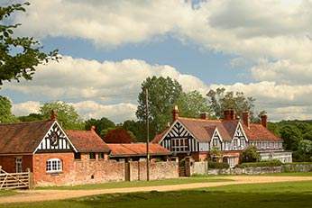
Allum Green is the smallest of the four hamlets, and is perhaps the least well-known. It really is ‘off-the-beaten-track’, but it has a history that goes back to Domesday. Swan Green, meanwhile, has a picturesque cricket pitch and perhaps the most photographed thatched cottages in the whole of England.
A bridleway winds over the hill to Emery Down, but this is not just any old bridleway. It borders the old Manor of Minstead and retains to this day a 19th century Manor of Minstead boundary stone by the trackside. The Manor dates back to at least the 11th century and it is tempting to suppose that the bridleway is of similar, or earlier, vintage.
An old bridge, known locally as the Roman Bridge, is used to cross Highland Water, whilst the Cut Walk, an early 18th century route originally constructed to link Lyndhurst with Burley, is travelled between the Roman Bridge and Swan Green.
The route includes magnificent ancient, unenclosed woodlands and a section of Highland Water, a beautifully high-banked New Forest stream.
It also passes close to the New Forest Reptile Centre where visitors have the opportunity of seeing adders, grass snakes, smooth snakes, lizards and much more. Here in recent springs and summers, visitors have also been able to view daily activity at the nest of a goshawk, a large, relatively scarce bird of prey, via live film footage shown on a big screen. Usually open from late March or early April until September, admission to the New Forest Reptile Centre is free, although a contribution is requested towards the cost of providing car parking facilities.
8.5 kilometres (5¼ miles).
Start:
Lyndhurst village centre.
Terrain:
Mostly level ground, but with two moderately steep hills. The route includes minor roads, a short(ish) stretch of the A35, a bridleway and areas of open New Forest land that, particularly in winter and early spring, can be wet and muddy. Strong boots are therefore recommended.
Please also note that the route close to Highland Water features a number of side-streams that have to be stepped or jumped across, and that floodwater can reduce the relevance of the walk instructions in Sections 5 and 6.
Refreshments:
The walk route passes The Waterloo Arms, the New Forest Inn at Emery Down, The Swan Inn at Swan Green and the Crown Hotel. Other pubs in Lyndhurst include The Fox and Hounds, The Stag and the The Mailmans Arms. There are also numerous tearooms, cafes and restaurants.
New Forest Tour bus route:
Yes - summer only.
Parking
There is a large 'Pay and Display' car park in the centre of Lyndhurst.
Walk route directions
1. Leave the village centre along Romsey Road – this is the road that enters the village at the traffic lights situated towards the top of the High Street.
Pass King’s Close on the left, and a thatched cottage, also on the left – this was once the site of a turnpike toll gate used by the Salisbury, Landford, Ower and Eling Turnpike Trust.
Pass a road on the left immediately beyond the thatched cottage – Forest Gardens - and after a short distance, follow the footpath to the left besides Gales Green, a small, relatively recently named village green.
2. Join a tarmac road leading to Pikes Hill, and follow it to the left. Ignore the next turn on the left into Calpe Avenue, and pass beside the 17th century Waterloo Arms – the first of our outlying pubs.
Continue straight ahead along this road, across a junction with Pikes Hill Avenue and Broughton Road. Pass on the left the entrance to Northerwood Farm and on the right the entrance to the village allotments. Follow the road as it bends to the left and passes the Fenwick2 Community Health and Well Being Centre and then bends to the right.
Eventually follow the road as it bends sharply to the left at a point where anther road joins from the right. Almost immediately, turn sharp left to follow a gravelled bridleway up a gentle incline beside a cottage called Stable End.
(Note: the road straight ahead here, Mill Lane, is narrow, often extremely busy and in places has no footpath. It is not recommended for pedestrian use).
3. Pass a picturesque thatch cottage on the right, and go between two rather worn out ‘dragon’s teeth’ placed to prevent access by vehicles. Pass a coppiced and pollarded ash tree on the right, mature ash and oaks on the left, and again on the right, a series of coppiced hazels - all indicate that this is an ancient track-way.
(From here, open aspects downhill over the fields to the right can be enjoyed, whilst in the distance beyond, wide expanses of woodland greet the eye. On the left up ahead, Northerwood Inclosure, which was first planted in 1811, borders the path - largely out of sight beyond the trees is Northerwood House, nestled on the hillside overlooking Lyndhurst).
Reach the top of the hill and follow the path round to the left.
(Notice the boundary stone leaning at an improbable angle by the track side on the right. On one side are the initials HCC, whilst on the other side is what appears to be an indecipherable 19th century date.
This stone was used to mark the boundary of the Manor of Minstead. It is not marked on modern Ordnance Survey maps, but is shown on some older versions. The initials refer to Henry Combe Compton, Lord of the Manor from 1803-1866).
Follow the path downhill to Emery Down and Silver Street.
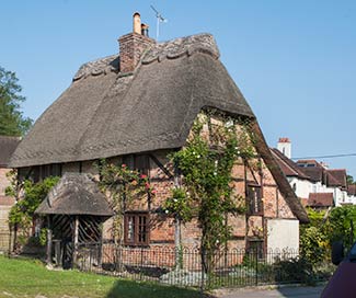
(The first cottage, another picturesque thatched building, is fittingly called End Cottage. The names of other properties do justice to the attractiveness of Silver Street, places such as Hare Hatch, Penny Cottage, Clematis Cottage, Wisteria Cottage and Honeysuckle Cottage.
Charcoal Cottage, marked with HV 1869, recalls charcoal burning occupations of previous Silver Street residents, including John Veal who in the 1841 Census was listed as a charcoal burner, aged 50. And nearby, high on the wall of number 15 Silver Street is a stone declaring ‘R. Veal, 1889’).
Pass on the left a set of old stone steps leading to a low, stone surround on the other side of the fence in Northerwood Inclosure, and at the next ‘T’ junction, turn right along the tarmac road.
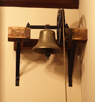
4. Pass a road joining from the right, and also pass the village church. Beyond, on the left, is the old village school.
(Notice the absence of the school bell from its tall, brickwork frame below the weather vane – it is actually preserved within the church. Note also to the rear of the side wall an ornate brickwork panel with the intertwined initials AD and the date 1885.
Across the road are the village alms houses. Church, school and almshouses all owe their existence to Admiral Frederick Moore Boultbee, who funded their construction costs - the almshouses are still known as Boultbee Cottage.
Directly ahead on the left is the New Forest Inn, the second of our outlying pubs, whilst a little further on, on the right, is The Old Vicarage, one-time home of an earlier inn, The Running Horse and later the residence of Admiral Boultbee).
Turn left alongside the New Forest Inn and go along the tarmac road sign-posted to Bolderwood. Pass the James Hill car park on the left, continue along the road and over the narrow heather strip of White Moor, and turn left into the White Moor car park just beyond.
5. Walk along the gravel track through the car park, and continue straight ahead past the low, Forestry Commission vehicle barrier. Follow the path as it eventually bears right; close to the woodland edge on the right, but with the open heathland of White Moor on the left.
Pass a group of invasive birch trees on the heath to the left, and a section of birch woodland on the right - birch trees can best be identified by their often slender, pale / white trunks.
At the bottom corner of White Moor, follow the path into a strip of woodland with, just beyond, an area of open ground on the right.
(Notice along here a series of magnificent, aged pollard beech trees amongst the young birches - the beech trees are smooth barked, large, mature examples, with multiple trunks growing from around head height).
Continue to follow the path as it drops downhill, with on the left, a narrow woodland stream bordered on either side by once-coppiced alders. The path terminates in this damp hollow, but dry ground can be found straight ahead, close to a narrow tributary of Highland Water. Turn right and follow the bank of this tributary until a narrow, very shallow crossing place is reached. Cross over and go straight ahead to reach Highland Water.
(Please note that this area, particularly in winter and early spring, can be very wet underfoot. Floodwater can also create additional stream channels which can confuse the walk instructions in this and the following section. Should this happen, a strong sense of direction and a willingness to improvise will help walkers regain the main route from Section 7).
6. Turn left to follow the river as it flows downstream through ancient, unenclosed woodland. Reach a small stream coming in from the left – other than after very heavy rain and subject to the note above, it is narrow, shallow and easy to cross at its junction with the main river.
7. Reach a bridge - known as the Roman Bridge - and turn left onto the Cut Walk.
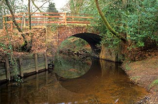
(A detour to the right here, across the Roman Bridge, leads to a wide, gravel track / road. Those wishing to visit the Reptile Centre should turn right along this gravel track; pass on the right after almost 0.5 kilometres, a keeper’s cottage; and the Reptile Centre is immediately beyond, on the right).
Follow the Cut Walk across a narrow valley bottom
(To the right in the distance, the property known as New Forest Gatehouse – this is another old turnpike cottage, once associated with the Christchurch and Lyndhurst Turnpike Trust).
Continue uphill into the wood, ignoring paths to left and right. At the top of the hill, the path separates into three – continue straight ahead, downhill along the central path.
Reach a quite wide lawn, and follow it downhill to the right towards Allum Green. Meet a ‘T’ junction of tracks adjacent to a boundary wall. Turn left to follow the main route back towards Swan Green.
8. Alternatively, a short detour to the right leads to the built part of Allum Green.
Pass Caister Cottage and Corner Cottage, then Allum Green Farm, followed by Beechwood House.
(Once perhaps more appropriately known as Allum Green House, Beechwood House was the home of George Fenwick, founder in 1908 of the Fenwick Hospital at Pikes Hill, which was constructed: ‘To the Glory of God and for the benefit of the suffering poor of Lyndhurst and the neighbourhood’. This was, of course, long before it became a Health and Well Being Centre.
Where the track swings sharply to the left, notice a bench seat in a clearing to the right. This was placed in memory of four men of the 8th A.F.W., or Army Field Workshop. W/O 2 H.S. Tyler, S. SGT. S.H. Avon, S. SGT. E.W.E. Gifford and SGT. A.W. Blunn all lost their lives in September 1940 during Second World War, Battle of Britain bombing of the area, this at a time when Allum Green House had been requisitioned for military use, and housed personnel evacuated from northern France following the Battle of Dunkirk.
The Battle of Britain was fought between 10th July and 31st October 1940, and has been described as ‘the most important event in Royal Air Force history’.
The campaign diary for Friday, 6th September 1940 notes: ‘In Hampshire: some serious grass and bush fires were started - believed due to bombs - and which it would appear from later information, are still raging and causing some anxiety. In the area near Lyndhurst where these fires occurred, several soldiers are reported to have been buried in Allum Green House (near Bank) on the explosion of HE (high explosive) bombs. Later, four reported killed and 14 injured.’
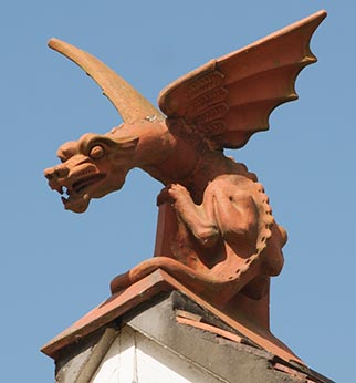
Notice, too, the striking but rather incongruous, grotesque dragon-like figures on the roadside building associated with Allum Green Farm).
Then retrace your steps past Corner and Caister Cottages and back to the ‘T’ junction of tracks.
9. Continue straight ahead alongside the boundary wall, pass a disused gated entrance, and eventually follow on beside a fence. Where the fence-line veers to the right, follow the path as it bends first left and then, almost immediately, right.
Go straight across at the next cross-road of tracks, cross a small stream at a bridge and follow the track as it starts to climb uphill.
The path eventually drops downhill to emerge at the corner of Swan Green, opposite the thatched cottages beside the Emery Down road.
Cross the left hand edge of the green and join the Emery Down road by the entrance to the Forestry Commission car park.
10. Turn right, pass the cottages and then turn left to follow the main A35 leading back into Lyndhurst.
(Here, directly opposite, is The Swan Inn – the last of our outlying inns).
Pass on the right after a short distance the squat form of a single storey lodge associated with the Cuffnells estate. Ignore a road joining from the right, and eventually pass on the right Hartwood House, a 'luxury care home' formerly known as Hill House, a property once used as a First World War hospital.
Ignore another road joining from the right alongside Queen’s House, then at the top of the High Street pass the Verderers’ Hall, the Parish Church of St. Michael and All Angels and the Crown Hotel.
Quick links
More links
Search this site