

New Forest Walks - Walks from Brockenhurst
Walk 1
Brockenhurst parish church, Brockenhurst Park, Roydon Woods Nature Reserve, Roydon Manor, ancient woodland and the Lymington River
Passed along the way
The Parish Church of St. Nicholas, Brockenhurst Park and House, Roydon Manor, Beaulieu World War Two Airfield; the site of Brockenhurst Mill; and the extravagantly designed North Lodge.
Parkland and farmland; Roydon Woods Nature Reserve; the Lymington River; Alder woodland near Dilton Farm; New Forest heathland around Furze Hill; Ancient, unenclosed woodland at Ivy Wood.
The route
Distance: 10 kilometres (6¼ miles). Approximately 1/3 of the distance covered is on the Crown Lands of the New Forest, whilst the remainder is outside the perambulation. Add a further 3 kilometres (1¾ miles) if starting the walk in Brockenhurst village centre.
The route can also be extended to take in the attractive village of Boldre, with its ancient bridge over the Lymington River, and historic parish church. The extension adds a further 4 kilometres (2½ miles). (Join the Boldre Walk route close to Roydon Manor, and return to this route at Dilton Farm. Check out the Boldre walk map and all should be clear).
Note: Mill Lane, used during section 12 of the walk, is a 'B' road - the B3055, but it can at times be very busy with traffic, and as the road in places in quite narrow and there is no footpath, great care is needed when walking along there.
Start: Brockenhurst parish church of St. Nicholas, where limited parking is available – SU305018.
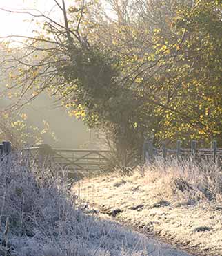
Terrain: Mainly on level ground, but with a small number of gentle gradients. Mostly firm underfoot, but in winter and after rain, some sections can be wet and muddy. Strong, waterproof boots are therefore recommended.
Railway station: Brockenhurst – 0.75 kilometres (½ mile).
Camping in the Forest camp sites: Hollands Wood, 1.5 kilometres (1 mile). Roundhill, 0.5 kilometres (1/3 mile) from the route.
Alternative starts: Brockenhurst village centre - car parking is available opposite the post office in Brookley Road – SU298024; Roundhill camp site – SU336023; and Ivy Wood car park – SU315024.
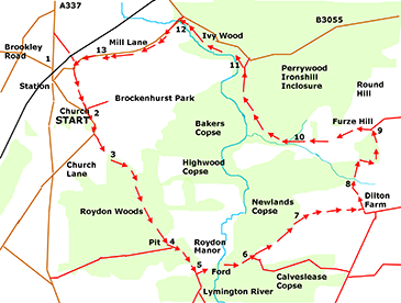
Directions
From Brockenhurst village
1. Go south from Brockenhurst village, along the A337 Lyndhurst-Lymington road, an 18th century turnpike road. Cross the railway line at the level crossing and immediately turn left into Mill Lane. After around 200 metres, as the road goes sharply left, turn right along a gravel track leading between Mulberry Cottage and the Georgian, Reynolds Cottage.
Continue up a gentle incline along what eventually becomes a green lane, an aged hollow-way lined with oak, coppiced hazel, ash, elder, holly and hawthorn, leading towards Brockenhurst’s historic parish church. Reach the church and an entrance to Brockenhurst Park on the left.
From the church
2. Follow Church Lane straight ahead, and at the top of a further modest incline, a glance to the left along a tree-lined avenue reveals Brockenhurst House, a 1960s construction of relatively modern design that replaced an earlier, 18th century building. After a short distance, opposite a drive leading to Beech Tree Cottage, turn left along a bramble-lined bridleway running beside the grounds of Brockenhurst Park.
3. Pass through a gate into Roydon Woods, a nature reserve managed by the Hampshire and Isle of Wight Wildlife Trust, and follow the path downhill, eventually leaving behind the parkland on the left and entering fully into the wood.
Reach a small stream at the bottom of the hill, and cross at the bridge. Notice here an enormous wood-bank, its massive proportions revealed in section on the right of the path.
Continue on, passing on the right another path leading deep into the woods. Cross another narrow stream and go uphill, through a gate with attached, a plaque stating that ‘the reinstatement of historic management practices to this complex of heath and pasture woodland is dedicated to the memory of Colin Tubbs’, a highly regarded local ecologist, ‘without whose tireless efforts many such areas would have been lost forever.’
At the top of the hill, the woodland on the left gives way to a field. Notice on the right just beyond the summit, a large, quite deep, overgrown pit half-hidden within the wood. Traces of gravel around the edge betray the original purpose, and the 1898 Ordnance Survey map confirms it as an old gravel pit.
4. Almost immediately reach a crossroad of tracks, the left-most entering the field, the others marked as bridleways. Continue straight ahead as the path again drops downhill. Pass a cottage on the left - The Lodge - and then an adjacent private track leading to Roydon Manor.
Carry straight on, gently downhill, with a field on the right and woodland on the left. At the far end of the field, pass a gate on the right.
5. Immediately after the gate, turn left through two gates in quick succession, alongside a steep bank topped with oak, ash, holly and coppiced hazel. (The path here eventually provides fine views of the elegant, 17th century Roydon Manor).
Pass a gate on the left leading to the Manor, and continue on downhill towards the Lymington River where a narrow footbridge serves the need of pedestrians, and a ford provides a crossing for vehicles and horse riders.
Cross the river – Roydon brickworks was on the left here - and follow the path uphill, with, after a short distance, the woodland of Newlands Copse on the left, and Calveslease Copse on the right.
6. Pass a bridleway on the right leading to Boldre, and continue straight ahead beside a wide expanse of grassland, ignoring a grassy ride leading into the wood on the left.
7. Leave the Roydon Woods Nature Reserve through a gate at the top of the hill, and continue along a sometimes muddy, in places hedged farm track bordered on both sides by grasslands but unfortunately partially edged by disused / discarded equipment and materials associated with the nearby farm.
Reach Dilton Farm, and turn left immediately before the first farm building with grasslands again on either side of the path. Go on downhill, eventually beside mature, broadleaved woodland on the left, until a narrow, alder-fringed stream is reached.
8. Cross the stream at a bridge and continue uphill, beside on the right a field marked on the map as Dilton Common. Go over the brow of the hill, and follow the path as it swings first sharply right and then, after 200 metres, just as sharply left.
Pass a small woodland pond on the right, and follow the path uphill with, on either side, yellow speckled gorse that warns of the heath to come. Notice on the left at the top of this short hill, close to a small, open barn, four ivy-clad, moss encrusted, dilapidated buildings associated with the site of the Second World War, Beaulieu Airfield.
Go downhill for a short distance, follow the path to the right and then immediately turn left, go through a gate and enter onto the Crown Lands of the New Forest.
9. Turn left to follow a concrete section of road beside a strip of heathland aptly known as Furze Hill. (The road, too, was part of the Beaulieu Airfield complex – it ran close to the Mess buildings).
Where the concrete section of roadway eventually gives way to a gravel track, pass between two sturdy, disused gateposts and continue on downhill to enter a section of ancient, unenclosed woodland along the edge of which flows a small stream, joined here by a side-stream from the right.
10. Ignore a turn on the left which fords the main stream, and continue straight ahead across the side-stream. Follow the path half-left, uphill, keeping quite close to the bank of the main stream. At the top of the hill, the path becomes a grassy track and the stream can be seen in the valley bottom to the left.
(On joining the grassy track, notice to the left an enormous earthen bank built at right angles to the path, and continuing across the stream; with to the right of the bank, an often very wet area of ground. Maybe the bank, with sluice, was used as a damn to create a fishpond; maybe it was used to harness the power of the water; or maybe it was simply a huge boundary bank).
After a short distance, take a right hand, rather indistinct fork in the path and soon after, notice a wood-bank and fence on the left, running roughly parallel to the path – this separates the Crown Lands of the New Forest from private, in part, coppiced hazel woodland.
Continue on along the path past knarled old oak and beech trees, through glades graced by silver birch and freshly pollarded hollies, and along, for a short distance, a hollow-way. Immediately after the hollow-way, cross a narrow side-stream, and follow the path as it gently meanders to left and right, before meeting the wood-bank on the left.
Cross another shallow side-stream, pass a gate on the left, and almost immediately go left alongside the wood-bank and fence - the original grassy ride continues uphill here, to meet the Brockenhurst to Beaulieu road. (Note: the way ahead along the next section of the route, down beside the river, can be very wet and muddy, particularly after winter rain, so some may prefer to continue to the road, turn left and re-join the walk route by the bridge, where Mill Lane is met at the start of section 14.
11. At the end of the fenced area, turn sharp left to follow the path down to the Lymington River. Notice through the trees across the river, a series of pronounced, low mounds, similar to those at Balmer Lawn, Brockenhurst, which have been shown to be the remains of intensely grazed purple moor grass tussocks.
Turn right and follow the riverbank for around 0.75 kilometres (½ mile), crossing a number of further side-streams using the bridges provided, and, on one occasion, resorting to use of a fallen trunk. Pass the Ivy Wood Forestry Commission car park, and eventually reach Mill Lane.
12. Leave the river bank here, and turn sharp left across the road bridge, into Mill Lane. Note: Whilst this is only a ‘B’ road – the B3055, it can at times be very busy, and as the road in places in quite narrow and there is no footpath, great care is needed along this section of the walk.
Notice on the right the neat garden and manicured lawns of Mill House. Here, coppiced hazels, ferns and enchanter’s nightshade adorns the roadside banks; to the left is parkland associated with Brockenhurst Park; whilst to the right, is agricultural land.
(From Longbow, a half-timbered, picture postcard thatched cottage, until close to North Lodge, the route on the map above is shown on the other side of the hedge, away from Mill Lane. This was permissive access provided by the landowner, but access has since been withdrawn. It is now necessary to walk along the minor road for some considerable distance).
13. Follow the road back to its junction with the A337, close to the railway level crossing, and turn right to return to Brockenhurst village.
To return to the church, turn left after a short distance, along a gravel track leading between Mulberry Cottage and Reynolds Cottage. Continue up a gentle incline, and the church is on the right.
More links
Other related links
Search this site
Sadly, 58 animals were killed - 35 ponies, 13 cows, 8 donkeys and 2 sheep, whilst a further 32 were injured - 3 pigs, 9 donkeys, 11 cows and 9 ponies.
(Forty-three accidents occurred in daylight, 15 at twilight and 101 in the dark. Twenty-seven accidents were not reported by the driver involved).
Here's just one horrific example - Three donkeys killed in collision with van at notorious New Forest blackspot (Advertiser and Times)