New Forest coastal walks
Keyhaven and Pennington marshes
This walk starts near the harbour in Keyhaven and follows the Solent Way north-east along the sea-wall towards Pennington Marshes and Woodside - in the direction of Lymington - before returning a little inland along the green lane affectionately known locally as the Ancient Highway.
Along the way, a number of paths are available that link the sea-wall with the return route so the length of the walk can be adjusted to suit individual preferences - distances range from 2½ miles (4 kilometres) to 4½ miles (7.5 kilometres) but, of course, those who prefer coastal views throughout might wish to walk alongside the sea-wall for as far as is desired, before going back the same way.
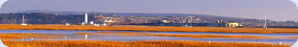
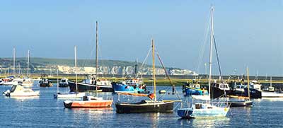
Hurst Spit and the Castle form a backdrop to early parts of the walk, whilst coastal views across the Solent to the Isle of Wight can also be enjoyed.
Birdlife is frequently abundant on a range of readily visible shallow lagoons, around the salt-marshes and wet meadows, and along the hedgerows so there's potential for seeing an impressive range of waders, wildfowl and other birds, many at close range.
Remember, too, the history of this place: the smugglers, sailors, wildfowlers, salt workers and others who made their mark upon the land, and maybe ponder what these folk of old would make of leisure walking, cycling, sailing and other opportunities afforded by modern life that we now tend to take for granted.
Find out more about Keyhaven, Hurst Castle, the Lymington salterns and Moses Dock and local coastal wildlife.
Discover, too, the 19th century exploits of Keyhaven-based wildfowler Colonel Peter Hawker.
From 2½ miles (4 kilometres) to 4½ miles (7.5 kilometres).
Start:
The central car park, Keyhaven.
Terrain:
Level, gravel tracks and firm ground.
Refreshments:
The Gun Inn, Keyhaven and the Chequers Inn, Woodside
New Forest Tour bus route: No
Parking
Park in the central car park at Keyhaven - Pay and Display - opposite The Gun Inn.
(Alternatively, a limited amount of short stay - up to 4 hours - free parking is available beside the sea-wall on the road leading past the Avon Water outflow, but space here is at a premium. Further limited parking is also available at the end of Lower Pennington Lane, although this is often congested and consists of little more than space beside the road where cars can park.
Route directions
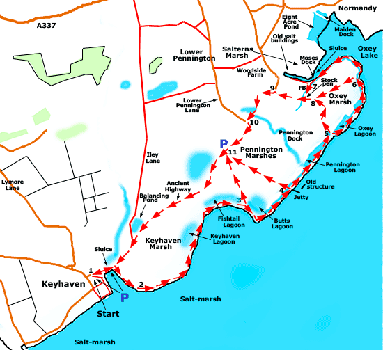
1. Leave the central car park by its northern entrance and turn right, alongside the road beside the sea-wall. Pass reed-fringed Avon Water on the left and a sluice linking it to the sea. Eventually, follow the sea-wall to the right, through a gate and continue straight ahead.
2. Continue along the path as it and the sea-wall bear round to the left, pass a number of small ponds on the left and the larger Keyhaven Lagoon a little farther on. The path eventually bears right at the far end of this lagoon and soon after passes Fishtail Lagoon.
3. At the far end of Fishtail Lagoon, there is an option to follow a path to the left, heading towards the Lower Pennington Lane car park which is at the start of section 11 on the main route.
Otherwise continue to follow the sea-wall, initially round to the right, passing beside the Butts Lagoon on the left. The sea-wall and path soon bear left and after a relatively short distance, reach on the right a concrete jetty with a pipeline below that extends out into the Solent. This, the Pennington outfall, is used for discharges from Southern Water's Pennington Waste Water Treatment Works.
(A little to the north-east of the jetty, out in Solent, are the skeletal remains of a section of the old sea-wall which, according to Ed Wiseman (One man's marshes - the birds of Lymington and Keyhaven), was abandoned in the mid-1930s following storm damage).
4. There is another opportunity here to turn left along another path leading to the Lower Pennington Lane car park, otherwise continue straight ahead, alongside the sea-wall and beside further lagoons of varying size.
5. After around 700 metres, go left, down from the seawall track, and follow another prominent, well-made, unsigned gravel track across the marsh.
Alternatively, instead of going left across the marsh, continue alongside the sea-wall for a further 800 metres, or so. Go left at point 6 on the map, down a series of wooden steps to follow a quite wide, well-trodden, unsigned grassy track that re-joins the main route mid-way across the marsh at point 8 on the map.
Or again at point 6 on the map, continue alongside the sea-wall for yet another 700 metres and pass a set of sluice gates on the right. Go down an adjacent set of wooden steps and continue along the path for around 150 metres, alongside a relatively narrow water channel.
Then where the path bears virtually 90 degrees to the right (at point 7), again continue straight ahead; almost immediately go left across a small bridge that spans a narrow drainage channel; and follow the path to the right, alongside the drainage channel to shortly after, re-join the main route during section 8.
8. Pass a fairly prominent, grassy track on the right (used as part of the first route extension above) and soon after, reach a stock pen on the right with adjacent gravel track used as part of the second route extension.
Continue straight ahead, past the stock pen, for around 200 metres before passing beside a private property.
9. Go through a gate; reach a narrow, tarmaced lane; and turn left along the lane. Pass a variety of well-spaced properties on the left and right, go through a gap where once there was a gate and continue along a gravel / dirt surfaced public footpath.
Go past on the right an overgrown pond screened by vegetation and on the left a very wet field much favoured by winter wildfowl and wading birds.
10. Meet a tarmaced road - Lower Pennington Lane - and follow this to the left, to the car park referred to in sections 3 and 4.
11. Continue straight ahead at the car park to follow what is known as the Ancient Highway, a well-made gravel track leading back to Keyhaven and the walk start point.
(The marsh is on the left virtually right the way along here, a large body of water on the right is almost immediately passed that takes up part of what in relatively recent times was the site of mineral extraction followed by landfill; whilst further along on the right is a 'balancing pond' associated with attempts to control water levels within the marsh).
Quick links
More links
Search this site