

A Burley walk starting at Wood's Corner
Also featuring - South Oakley Inclosure, Berry Wood, White Moor Bottom, Turf Croft and Forest Road
Overview
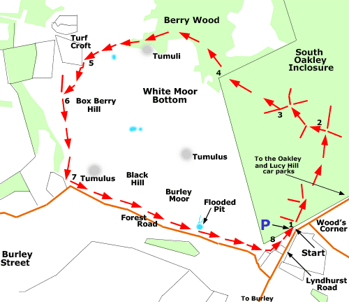
This three mile (4.8 kilometres) walk is primarily on level ground with no hills of consequence along the way. It starts from the Wood's Corner car park, located on Lyndhurst Road, around one mile (1.6 kilometres) from Burley village centre.
The early part of the walk route is along a gravel cycle track leading through South Oakley Inclosure - an attractive area of broad-leaved woodland with scattered blocks of conifers - before the route goes north-west along lesser but clearly visible paths.
The magnificent ancient, unenclosed woodland of Berry Wood is next encountered before the wooded landscape gives way to open heathland around Turf Croft.
The route then veers south beside Box Berry Hill and alongside the heathlands and wetlands of White Moor Bottom where patches of open water attract herons, little egrets and a range of wildfowl.
Return to the Wood's Corner car park is alongside the minor Forest Road.
As the walk for much of the way follows around the edge of White Moor Bottom, there are many opportunities to leave the main route to explore this extensive, low-lying area of heathland and wetland without too much danger of getting completely lost.
Along the way
South Oakley Inclosure was created in 1853, shortly after the 1851 Deer Removal Act reached the Statute Book. It lies on what originally was mainly open heathland with scattered trees, although there were already areas of ancient, unenclosed woodland present - during the later stages of section 1 of the walk route and during sections 2 and 3, look out for occasional ancient pollarded trees, remnants of the original Oakley Wood that were spared the axe all those years ago when the inclosure was created.
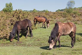
Fallow deer and roe deer may be encountered within the woods and on the heath, whilst a small herd of red deer may also be seen.
A group of Bronze Age barrows, burial mounds dating back around 3,500 years, is present close to the walk route, a little south of Berry Wood - shown on the map as 'Tumuli'. Single Bronze Age barrows are also present, shown as 'Tumulus'.
Also of historical interest are properties at Turf Croft and along Forest Road, for map makers Richardson, King and Driver in the late 18th century / early 19th century showed 'Incroachments on the Forest' on these sites, that is, dwellings on land originally taken illegally from the Forest.
Three miles (4.8 kilometres).
Start:
Wood's Corner car park - one mile (1.6 kilometres) from Burley village centre.
Terrain:
Largely on level, firm ground with only very moderate gradients.
Refreshments:
There are a number of pubs and tea rooms in nearby Burley.
New Forest Tour bus route:
Yes - summer only, through Burley.
Parking
Park in the Wood's Corner car park at the start of the walk. Should there be no space available at Wood's Corner, alternative parking can be found in the Oakley and Lucy Hill car parks - both are around ½ mile (a little over 0.75 kilometres) away to the north-east, along Lyndhurst Road.
Walking from Burley village centre
Leave Burley with the Queens Head pub on your left; immediately follow Chapel Lane to the left, almost beside the pub; and continue along this minor road until Wood's Corner is reached.
Walk route directions
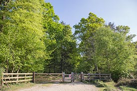
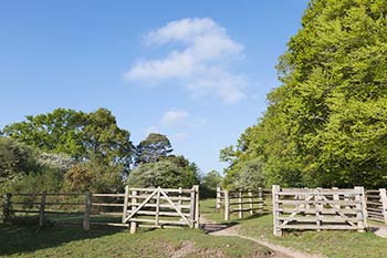
1. Leave the car park (cycle track post number 112) through the adjacent gate and follow the gravel cycle track in a north-easterly direction into South Oakley Inclosure. Ignore a number of grassy rides on the left, and after around 500 metres, at a crossroads - cycle track post number 111, situated at the top of a gradual incline - turn left along a gravel / grassy track. (The cycle track here continues straight ahead, whilst to the right is a grassy dirt track).
2. Continue up a further gentle incline; after around 200 metres, pass a narrow path on the left running downhill amongst conifers and other trees; and continue along the main track as it bears to the right. Shortly after, as the gravel track bears further to the right, turn left at a crossroads along a quite wide, grassy dirt track - to the right here is also a grassy dirt track.
3. After a short distance, go through a gate on the right and follow a quite narrow but reasonably prominent grassy / dirt track as it continues uphill.
(Eventually visible through the trees away to the left is the open heathland of White Moor Bottom - keep this in sight and progression along the intended route is virtually assured).
4. When around 400 metres from the gate, leave the inclosure through a break in the moss-clad boundary bank and enter the majestic ancient and ornamental woodland of Berry Wood - the White Moor Bottom heathland remains visible through the trees on the left, whilst to the right is an un-named area of heathland.
Follow a minor path that bears half-left after the boundary bank, and eventually follow the woodland / heathland edge as that too bears gradually left. Upon reaching a very narrow strip of woodland, follow a wide, grassy track out onto the heath heading in the direction of the properties at Turf Croft and, beyond, a distant telecommunications mast.
5. Immediately before Turf Croft is reached, follow the path as it bears left and shortly after, continue along a quite wide, gravelled road beside heathland and distant wetland on the left, and heathland with woodland beyond on the right. Notice Box Berry Hill - a prominent hillock on the left - and at the next junction of gravel, vehicle width tracks, go left.
6. Continue straight ahead for around 650 metres.
7. Go left at the next junction to follow alongside a minor road: Forest Road. Eventually pass on the left what appears to be a small flooded, long disused, overgrown gravel pit; and Brookside Farm on the right.
Soon after passing the pit and farm, as the road bears right, go left and walk parallel to the boundary of a private property.
8. Up ahead can then be seen Lyndhurst Road and a stock pen, whilst a little beyond, on the left, is the walk start point: the Wood's Corner car park.
Quick links
More links
Search this site