

Castleman's Corkscrew walk - Burley
Also featuring - Turf Hill, Holmsley Bog, Slap Bottom and Shappen Hill.
Overview
This 3¼ mile walk (a little over 5 kilometres) features much relatively level ground with few significant gradients. The route starts in the Burley, Forestry Commission car park, located on Wilverley Road, opposite Burley Primary School, around 1/3 mile (0.5 kilometres) from Burley village centre.
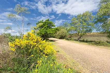
Much of the route is over open heathland characterised by a fine mix of heather; gorse; bracken; invading birch and ancient, once-coppiced hollies. Heathland wildlife hereabouts is of national importance - look out for tiny Dartford warblers; noisy, conspicuous stonechats; small groups of chattering linnets and many other wild birds.
*** Find out lots more about New Forest heathland wildlife. ***
Fallow deer and roe deer are also present and are most often seen early and late in the day, whilst wild flowers, butterflies, dragonflies, damselflies and reptiles add considerable further interest.
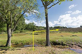
Panoramic views at first glance present vistas over relatively flat ground, overlooked by often huge skies, although hidden dips in the landscape conceal shallow valleys, narrow streams and wildlife-rich wetlands.
Along the way
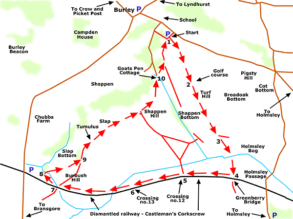
The walk route leaves Burley car park in a south-easterly direction and initially crosses gently undulating, open heathland before passing over Holmsley Bog on a raised section of path. The remains of Greenberry Bridge are reached from where the course of Castleman's Corkscrew, a dismantled railway line, is followed westwards.
(Castleman's Corkscrew opened for business in the mid-19th century to link Southampton with Dorchester and many places in-between. The railway closed in the 1960s, a victim of the infamous Beeching Axe, and this part of the old track-bed is now a popular walking and cycling route).
*** Find out lots more about Castleman's Corkscrew. ***
From close to Burbush car park, the route veers north-eastwards, again across open heathland. Slap Bottom is by-passed along the way close to where a Bronze Age burial mound - shown on the map as a tumulus - lies beside the track, just as it has done for the last 3,500 years, or so. Slap and Shappen Hill are next encountered, then Goats Pen Cottage and a block of ancient woodland before the walk's start and end point at Burley car park is reached.
(The place name 'Slap' was already in use here in the late 18th century and its origin has been said to have possibly been associated with a slope or slant, whilst 'Bottom' is used in the same sense as 'valley bottom'. Similarly, various origins have been suggested for 'Shappen', including a link to 'Sheppen' or sheep pen. Again, this name was already in use in the late 18th century).
3¼ miles (a little over 5 kilometres).
Start:
Burley, Forestry England car park.
Terrain:
Largely on level, firm ground with few significant gradients.
Refreshments:
There are a number of pubs and tea rooms in Burley, whilst the Old Station Tea Rooms at Holmsley are nearby - mid-way through the walk, turn left at Greenberry Bridge and follow the Castleman's Corkscrew track-bed for around 1 mile (a little over 1.5 kilometres).
New Forest Tour bus route:
Yes - summer only, through Burley.
Parking
Park in Burley car park at the start of the walk. Note, however, that alternative parking is available near the Queen's Head in Burley village, at Burbush and also close to Holmsley Passage.
Note
In winter or after heavy rain, the valley bottom by Goats Pen Cottage - at the beginning of Section 10 - can be so wet as to be virtually impassable. If this is the case, follow the gravel, vehicle width track leading uphill, away from Goats Pen Cottage, and eventually turn right, through the woodland, to reach Burley car park; or continue on to the road beyond.
Walking from Burley village centre
Leave Burley with the Queen's Head pub on your left and immediately follow School Hill as it bears right, uphill, past the 'Bread Stone' tucked away in the bank on the left. The walk start point is on the right, beside the road around 350 metres away.
Walk route directions
1. Take the fairly pronounced gravel track that goes off in a south-easterly direction across the heath, at virtually 90 degrees from the car park - the track starts at the beginning of the final large parking bay, opposite a line of three strikingly handsome oak trees at the edge of the adjacent wood.
2. After around 500 metres, pass on the left a Burley Golf Club green, and follow the track as it leads virtually straight ahead towards the distant woodlands of Holmsley Inclosure.
3. After a further 600 metres, follow the track downhill and cross Holmsley Bog, a fairly wide expanse of wetland with a narrow stream at its centre - the path here is well-made and forms a causeway raised above the level of the bog.
Continue on along the main gravel track as it climbs the opposite valley side, and after 200 metres, at the crumbling remains of Greenberry Bridge, meets the track-bed of the now dismantled Castleman's Corkscrew railway.
4. Go right here, along the course of the old railway line, initially within a cutting dug by hand by hard-working navvies employed by the Victorian railway engineers, so as to reduce or eliminate gradients too steep or too impractical for locomotives to tackle.
5. After around 450 metres, pass a set of old, disused level crossing gateposts and adjacent on the left, within a small copse, the remains of the railway crossing keeper's cottage and associated buildings - this was the Southampton and Dorchester Railway crossing number 12.
(The right turn here, between the gateposts, offers a shortened route back to Shappen Hill and on to Burley car park).
6. After a further 450 metres, pass another small copse on the left, another set of level crossing gateposts partially concealed by vegetation, and the remains of the associated railway crossing keeper's cottage - number 13.
After another 200, or so, metres, reach an unnumbered cycle track post at a metal bridge over a narrow, overgrown stream or drainage channel.
Eventually enter another cutting, excavated through the tree-clad edge of Burbush Hill. Leave the cutting, almost immediately cross a small railed bridge over a narrow stream, and continue straight ahead for a short distance.
7. Reach cycle track post number 158 and follow to the right an initially sandy / soil-based track that after a few metres becomes a not-too-prominent grassy track.
(50 metres, or so, along the track-bed, beyond cycle track post number 158, can be found the remains of the old Burbush Bridge).
8. After around 150 metres, adjacent to the start of a block of woodland up ahead, turn right, cross a narrow stream that is often dry in summer - no bridge is available but other than after very heavy rain, the stream can be quite easily stepped across - and go along a track that runs broadly parallel to the woodland edge away to the left. (The Burbush car park is not too far away to the left of where the stream is crossed).
Follow the rutted sandy / grassy track up a gentle incline and on across the heath, again walking broadly parallel to the woodland edge away to the left.
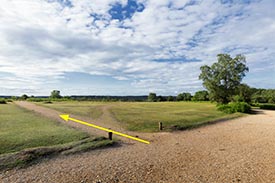
9. After around 250 metres, go left at a 'T' junction that is close to the edge of a small copse on the left and also close to the point where a line of overhead wires crosses the track, and follow a sandy / gravel / grassy track that again leads up a gentle incline.
Continue straight ahead along this fairly wide, prominent undulating track that eventually almost skirts the left-hand woodland, and follow the still prominent track downhill into a valley bottom where can be found Goats Pen Cottage on the left.
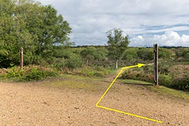
10. Cross a narrow, valley-bottom stream - it's usually dry in summer - and follow the equally narrow but for much of the year fairly obvious path uphill beside the left-hand woodland edge - there is open heathland on the right-hand side here.
When almost at the top of the hill, go left at a 'T' junction to follow a wider track back to the car park, which is 200, or so, metres away on the edge of the left-hand woodland.
Note: In winter or after heavy rain, the valley bottom by Goats Pen Cottage can be so wet as to be virtually impassable, whilst in summer, the path leading up from the stream may be obscured by vegetation. If necessary, then, follow the gravel, vehicle width track leading uphill, away from Goats Pen Cottage, and eventually turn right, through the woodland, to reach Burley car park; or continue on to the road beyond.
References:
Records of Burley - aspects of a New Forest village: F. Hardcastle B.E.M.
Quick links
More links
Search this site