

New Forest Walks - Walks from Brockenhurst
Walk 4
Balmer Lawn, the site of the Victoria Brick and Tile Works, mature broad-leaved and coniferous woodlands
Passed along the way
Balmer Lawn; Victoria Brick and Tile Works; Ancient, unenclosed woodland around Standing Hat; Broad-leaved and Coniferous woodland inclosures - Pignalhill, Parkhill, Stubby Copse and Pignal Inclosures; and Southern wood ant nests.
The route
Distance: 4.5 kilometres (2¾ miles) - add a further 3.5 kilometres (2 miles) if starting the walk in Brockenhurst village centre.
Start: The Tilery Road car park at SU307033, 1.75 kilometres (1 mile) north-east of Brockenhurst.
Terrain: Mainly on level ground, but with a small number of gentle gradients. The walk is on well compacted, well-drained cycle tracks throughout; and is likely to be relatively firm underfoot, almost whatever the weather.
Railway station: Brockenhurst, 1.75 kilometres (1 mile) to the south-west.
Camping in the Forest camp sites: Hollands Wood, 0.5 kilometres (1/3 mile) to the north-west.
Alternative starts: Brockenhurst village centre car parking is available opposite the post office in Brookley Road – SU298024. Parking is also available at the Standing Hat car park, on the route, 1 kilometre (0.6 miles) away from the Tilery Road car park.
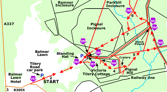
Directions
From Brockenhurst village
1. From Brockenhurst, leave the village centre on the A337, heading north towards Lyndhurst. Cross the Lymington River at what is known as the Brockenhurst Bridge, and immediately turn right down a minor road signposted to Beaulieu and Roundhill camp site. The Balmer Lawn Hotel can be seen to the left, whilst a small car park beside the river is on the right.
After almost 0.5 kilometres, where the road bends to the right, follow a wide, gravel Forestry England track leading straight ahead towards the distant woods. The Tilery Road car park is a short distance ahead on the left, a little past cycle track post number 293.
From the Tilery Road car park
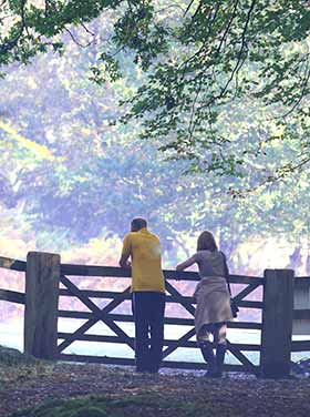
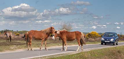
2. Continue along the gravel track leading away from the road and on towards the woods. On the left is the wide expanse of Balmer Lawn, a favourite grazing place for commoners’ stock, animals that can always be relied upon to always keep the grass short, just as if it were regularly mown.
Almost immediately pass a Forestry England vehicle barrier and cross over a low, railed bridge that takes the gravel track over a narrow drainage channel; pass on the right a small, gorse-strewn area of grassland bordered by broadleaved trees; and on the left, ancient, unenclosed woodland. At cycle track post number 292, go left at a fork in the track signed 'All cyclists, walkers and vehicles this way' - straight ahead is a private road leading to Victoria Tilery Cottage.
Standing Hat, with its own small car park, is on the left, at the entrance to an extensive block of woodlands.
3. Immediately before entering the woodlands, turn right - opposite on the left, the Standing Hat car park entrance; pass cycle track post number 291 and immediately after, a Forestry England vehicle barrier; and follow the gravelled cycle track as it eventually passes behind a cluster of buildings (obscured by trees) associated with Victoria Tilery Cottage.
Continue along the cycle track as it bends to the right, ignoring here a wide, grassy drift-way going straight ahead. Immediately pass through a gate, and then almost immediately (at cycle track post number 306) ignore a gravel track on the right leading to the Victoria Tilery Cottage buildings.
4. Eventually follow the cycle track as it bears left, and after a short distance goes over a minor crossroads - the right turn here is a grassy dirt track, whilst the left turn is a grassy ride. Notice along here on the left, by the minor crossroads, a number of circular craters / depressions amongst the trees. They are World War Two bomb craters - during the conflict, around 2,700 bombs apparently fell on the New Forest, some of which came down on Brockenhurst and the surrounding area.
Eventually enter an area of primarily coniferous woodland and follow the cycle track as it bears left, past a grassy ride on the right.
(Look out along here for often sizable nest mounds created by Southern Wood Ants, the mounds constructed of pine needles, twigs and other pickings from the woodland floor).
5. Follow the cycle track as it bears to the right, ignore relatively minor turns to left and right, and eventually go left at the first crossroad of cycle tracks - at cycle track post number 305.
Eventually pass through a gate at cycle track post number 304, with immediately beyond on the left, a small stock pound at the edge of a wide, grassy ride. Leave the primarily coniferous woodland behind and follow the cycle track as it goes slightly right, and then left at cycle track post number 303 and on through another gate. Ignore immediately after the gate, a quite wide grassy ride / path on the left and continue along the cycle track as it eventually bears to the right.
6. Turn left at the next crossroad of cycle tracks at cycle track post number 288 - confusingly, as at May, 2019 this shows on the official New Forest Cycle Map as post number 287, although the cycle map and what is present on the ground might well eventually be made to correspond.
Continue along the track as it first bears left and eventually goes quite sharply right - past on the left a quite pronounced, grassy ride - and on up a gentle incline.
More links
Other related links
Search this site
Sadly, 58 animals were killed - 35 ponies, 13 cows, 8 donkeys and 2 sheep, whilst a further 32 were injured - 3 pigs, 9 donkeys, 11 cows and 9 ponies.
(Forty-three accidents occurred in daylight, 15 at twilight and 101 in the dark. Twenty-seven accidents were not reported by the driver involved).
Here's just one horrific example - Three donkeys killed in collision with van at notorious New Forest blackspot (Advertiser and Times)