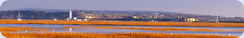
Lepe – its history and heritage
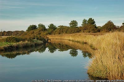
When looking at the history and heritage of Lepe, it's reasonable to start with the name of this tiny hamlet, part of the Exbury and Lepe civil parish. It is said to derive from the Old English for a 'leaping place', especially for deer: the site of a fence, maybe, or even a stream - here the Dark Water river - over which energetic deer can jump. From 1575 until 1645 it was shown on old maps as Leape. It was shown as Leap from 1695 until at least 1826, and then the current spelling was used in 1864 and it has remained so ever since.
And following on from the name, is a brief introduction to many of the more significant aspects of Lepe's rich history:
(Skip down the page to find out more about Lepe Country Park, Lepe walks and Lepe wildlife).
(1) A Roman road and the Great Storm
The possibility of a Roman road running down to the shore at Lepe has for decades puzzled historians, some of whom were not convinced by arguments for its existence.
However, a relatively recent investigation by the late Arthur Clarke ESA, the last Archaeology Officer of the Ordnance Survey, convincingly confirmed that the Romans did indeed build a road from Shorn Hill, a little north-west of Calmore - where there was a junction with another Roman road leading from Otterbourne to Stoney Cross - through Applemore Hill and onwards to Stone Point, Lepe, where there apparently was an inlet with berths for shipping.
However, to some extent, confusion continues to reign for current maps show what appear to be parts of the route simply as 'Earthwork', whilst a section on the same alignment is marked as 'Roman Road (course of)'.
The harbour of the Romans no longer exists and was possibly destroyed in what has been termed the 'Great Storm' of 1703 that hit central and southern England causing huge damage, including the collapse of 2,000 chimney stacks in London and the loss of 4,000 New Forest oaks.
The storm is said to have destroyed much of Lepe village and at least one other nearby harbour. Old maps from before that time show that the Dark Water river used to flow out to the east of where it does now, and that in the 17th century a tide mill was situated close to the old outflow.
The tide mill site has been lost to coastal erosion, by tradition during the 'Great Storm', but the 28 acre tidal pond can still be identified.
(2) Smuggling at Lepe
Customs duties on selected imported goods have been levied since at least the year 979AD.
Understandably, many people objected to the levies and so the art of smuggling was born, but this illicit trade, whose heyday was from around 1700 until 1850, has for centuries been cloaked in secrecy and as a result it's often difficult to tell fact from fiction.
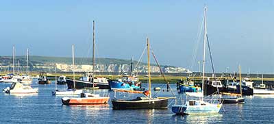
We can be certain, however, that the quiet waters of the Solent, including those at Lepe, provided ideal places to unload smuggled cargoes.
Indeed, one of the more notorious late 18th century smugglers, Billy Coombs, was apparently hanged at Stoney Point, Lepe, for his involvement in a naval battle between smugglers and the Navy during which Captain Coombs, seemingly mistakenly, continued to fire even after his ship had signalled surrender.
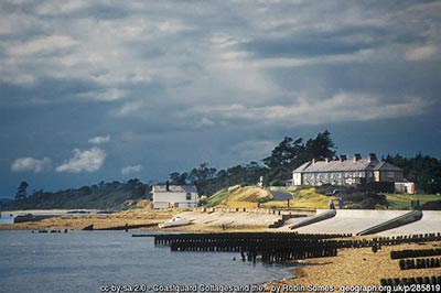
On the seafront beside the road from Exbury, the Coastguard Cottages at Lepe date back almost to the time of the unfortunate Billy Coombs and so does the adjacent Watch House. All were constructed in 1828, shortly after the creation in 1822 of the Coastguard service, successor to the Preventive Water Guard, which had responsibilities for the prevention of smuggling and assisting at shipwrecks by taking action to save lives, taking custody of the vessel and protecting property.
The Preventive Water Guard, in a confused hotch-potch of responsibilities, had complemented the work of the Board of Custom's shore-based Riding Officers and the Board of Excise's sea-going Revenue Cutters. Rationalisation was long overdue and the creation of an all embracing Coastguard service that brought together all the roles and responsibilities under one umbrella organisation was an eminently sensible step forward.
Greenwood's 1826 map of the area continues to show the presence at Lepe of a Preventive Station, whilst the 1869 Ordnance Survey map uses the updated terminology of Coastguard Station and Boat House, the latter also eventually known as the Watch House.
Externally, the Coastguard Cottages and Watch House remain largely unchanged, although in 2014 architects were commissioned to design refurbishment works for the Watch House to provide modern living accommodation.
(3) 18th century shipbuilding at Lepe

Shipbuilding on an industrial scale came to Lepe in the 18th century when Moody Janverin, a master shipwright who built a number of ships for the Royal Navy at Bursledon and Hamble, was asked in 1744 to establish a shipyard at Lepe.
This he did whilst continuing to work in the Hamble valley, going on at Lepe to build HMS Greenwich (1,053 tons), which was launched in 1748; followed in 1749 by the 6th Rate, 28 gun frigate HMS Fowey (513 tons) which was sunk in 1781 in action with the French at the Chesapeake.
Abandoned by Janverin in 1749, the Lepe shipbuilding site remained idle until 1763 when Henry Adams, of Bucklers Hard fame, came in and built the 64-gun Europa (1,379 tons) which was launched in 1765 and in 1778 renamed HMS Europe.
A harbour that escaped the ravages of the 'Great Storm', or a re-build, or a more recent construction, was said to have been silted and beyond use by 1825.
From at least the mid-18th century, maybe as a result of the thirst of shipyard workers, there was sufficient custom to warrant the operation of a local ale house that was shown on the 1871 Ordnance Survey map as The Ship Inn.
By 1897 it had become Lepe Cottage and would eventually form the core of Lepe House, a property that was substantially altered and enlarged in the late 19th and early 20th centuries.
(4) The Lepe lighthouse
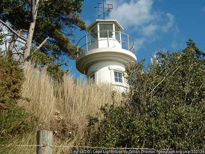
The lighthouse at Lepe, situated in the grounds of Lepe House, appears to be of great age as its features follow traditional lighthouse design.
More accurately known as the 'Millennium Lighthouse - The Beaulieu River Beacon', it does, however, only date back to the year 2,000 when it was built to both celebrate the millennium and also as a beacon to guide yachts and other vessels safely into the mouth of the nearby Beaulieu River - the channel is marked by dolphin piles but is still difficult to navigate, especially in strong cross tides and at night.
Standing at a fairly modest height of 7.6 metres (25 feet), the lighthouse's design and siting were chosen so as to be in keeping with the area and also as a local feature visible from the sea, from along the coast and from the visitor area of Lepe Beach.
The opening ceremony on Saturday, July 8th 2000 was performed by the Lord Lieutenant of Hampshire, Mrs Mary Fagan, in the presence of Lord Montagu of Beaulieu, Ted Fort OBE (Chairman of the Beacon Committee), John Edward (Harbourmaster) local residents, river users and members of the Association of Lighthouse Keepers.
(5) Wartime connections

In common with many other parts of the south coast, Lepe played a prominent role in the preparations for the D-Day landings on the Normandy beaches in June, 1944.
A pivotal action, code named Operation Overlord, that played a significant role in bringing the Second World War to a successful conclusion, the D-Day landings were over two years in the planning which for obvious reasons were shrouded in secrecy.
Thankfully, the build up of troops, equipment and supplies - concealed amongst trees and along winding country lanes - went unnoticed by Luftwaffe aircrew who could have brought the whole enterprise to a sad, premature end before a craft had even left these shores.
Many thousands of troops with their equipment and supplies set sail for Normandy on the 6th June, 1944, primed to storm the beaches, drive the German army out of France and in so doing initiate the beginning of the end of World War Two.
Lepe played its part to the full as a major departure point; as a construction site for sections of floating Mulberry Harbours; and as the site of the PLUTO (Pipe Line Under The Ocean) oil pipeline which was used to supply fuel to the advancing allied army - the pipeline was constructed between 1944 and 1945 but has since been destroyed.
In 1943, Lepe House was requisitioned by the Royal Navy for use as the administrative base for J.1 Assault Group for the D-Day landings, whilst Free French and Polish commandos trained for intelligence operations at nearby Inchmery House.
(Exbury House and estate were requisitioned by the Admiralty for use by Naval Intelligence and as a local centre for D-Day planning; Pylewell House, near Lymington, became the site of Lymington Airfield (or Pylewell Airfield, as it was also known); whilst the Beaulieu estate is perhaps best known for its role as a training base for Special Operations Executive (SOE) agents).
Today, evidence of this magnificent enterprise can be seen at the eastern end of the beach at Lepe, 800 metres (½ a mile), or so, east of the car parks. Remains include a concrete road built to take troops, supplies and materials to the construction and embarkation sites; beach hardening mats used to enable the beach to take the weight of tanks and other vehicles; and 'dolphins' - four-legged metal structures that were part of the pier-heads used as mooring points for ships and landing craft.
(A very informative 'D-Day at Lepe' leaflet is available from the Country Park information centre, whilst interpretation panels providing further information are in place by the remains and are also expected to be installed by The Outpost restaurant / café).
And finally, dating from way after the end of World War Two, a Royal Observer Corps monitoring post was opened during April 1962 and closed in September 1991.
Built as part of an extensive network designed to confirm and report hostile aircraft and nuclear attacks on the United Kingdom, the site is located in a small rectangular compound beside the Solent Rescue hut in the upper car park of the country park.
Find out more about Lepe and the Country Park
References:
Smuggling in Hampshire and Dorset 1700-1850: Geoffrey Morley
The New Forest at War: John Leete
They flew from the Forest: Alan Brown
Lepe Estate
Roman Road - Hants Field Club
Coastguard and Waterguard
Quick links
More links
Search this site