New Forest coastal walks
Keyhaven, Hurst Spit and the Castle
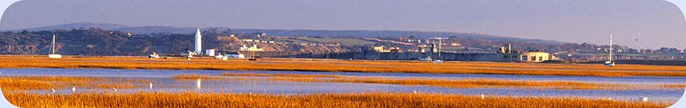
This at times bracing, but always exhilarating walk starts close to the harbour in the picturesque village of Keyhaven before following the sea-wall to the south-west and then heading south-east along the narrow shingle spit upon which Hurst Castle is situated.
The castle was originally built to defend the western approach to the Solent and was completed in 1544 as part of a chain of coastal fortresses constructed during the reign of Henry VIII to counter possible invasion by the French. Subsequent alterations included the addition in Victorian times of two huge wings that dwarf the original castle.
The latest of a succession of lighthouses remains prominently visible at the end of the spit, although little evidence remains of the once bustling community that used to exist nearby.
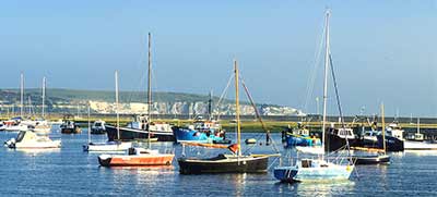
Fine views across the Solent to the Isle of Wight are available throughout the walk, whilst the open waters of Christchurch Bay lie to the west and on clear days, the Isle of Purbeck's chalk cliffs and stacks around Old Harry Rocks are visible in the far distance.
Birdlife is frequently abundant in and around the offshore salt-marshes; unusual, salt-tolerant plants grow in the marshes and amongst the shingle; and from mid-May until towards the end of June, rare Glanville fritillary butterflies can sometimes be seen on the wing around the Castle.
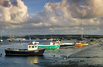
The Hurst Castle ferry usually runs from the end of March until the end of October - check here for the latest up-to-date ferry information.
*** Find out lots more about Keyhaven, Hurst Castle and the Spit and the local coastal wildlife. ***
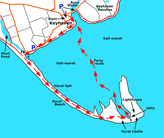
4½ miles (7 kilometres).
Start:
The central car park, Keyhaven.
Terrain:
Level ground but be aware, the walk along the Spit can be, well, interesting: the Spit is very exposed to the weather and the stones are quite loose rather than compacted - it's not exactly like walking through sand, but getting on that way.
Refreshments:
The Gun Inn, Keyhaven and the Hurst Castle Café
New Forest Tour bus route: No
Parking
Park in the central car park at Keyhaven - Pay and Display - opposite the Gun Inn.
(Alternatively, a limited amount of short stay - up to 4 hours - free parking is available beside the sea-wall on the road leading past the Avon Water outflow, but space here is at a premium. Further roadside parking is also available closer to Hurst Spit).
Route directions
1. Leave the car park at its northern end, close to the Avon Water outflow; turn right a little before the tarmac road is reached - adjacent to a Scouts' building - and follow the sea-wall round to the right.
Pass the Harbour Master / River Warden's tower and a concrete area beside the harbour used by fishermen and others, cross a tarmac road leading to an area of gravel from where yachts and other small vessels are launched, pass the Hurst Ferry mooring and follow the sea-wall as it bears round to the right.
(Alternatively, leave the car park by its main entrance, go left for a short distance alongside the tarmaced public road, and where the road bears right, go straight ahead to reach the sea-wall).
2. Continue along the sea-wall beside a channel of water that runs between the salt-marsh and the land with, visible in the distance across the marsh, Hurst Spit, the Castle and lighthouse, and beyond, the rolling hills of the Isle of Wight.
3. Eventually join a tarmac road and continue straight ahead towards the hump-backed shape of the Spit 400 metres, or so, away.
Note - this road is liable to flood during high tides and the Environment Agency advise that it will then be closed.
4. Where the tarmac road goes sharply right, close to the Spit, continue straight ahead across a bridge over a relatively narrow water channel that leads from nearby Sturt Pond to the open waters of the Solent, and then go left along the Spit, heading towards the distant Castle and lighthouse.
(Use the path along the top of the Spit or walk along its base, either on the seaward or salt-marsh side, according to your preference and prevailing weather conditions).
5. Reach the end of the Spit, explore the Castle and the ruins of other structures, imagine the Spit's bustling community of old, wander the marsh, wonder at the lighthouses that have been responsible over the years for safeguarding so many lives; or simply relax before returning to Keyhaven on the ferry or retracing the outward route back along the Spit.
Quick links
More links
Search this site