New Forest Cycling
Cycle ride 9
Woodland in-between Brockenhurst and Burley – Wilverley Inclosure
Start: Wilverley Plain car park, adjacent to Wilverley Plain and Wilverley Inclosure (SU 254011).
Station: Sway, 3.5 kilometres (2 miles).
Camping in the Forest campsite: Setthorns 1.75 kilometres (1 mile).
Alternative starts: The nearby Yew Tree Bottom and Wilverley Inclosure car parks.
Distance: 4.5 kilometres (2 3/4 miles), all off-road, but with a number of short, quite steep, gradients.
Extend the route: Optionally cycle along the nearby old railway line - Castleman's Corkscrew - towards Brockenhurst or Burley.

Wilverley Inclosure, situated between Brockenhurst and Burley, and conveniently close to the A35 Lyndhurst to Christchurch Road, provides the location for this entirely off-road cycle ride along a very manageable 4.5 kilometres (2 3/4 miles) circular, woodland route that does, however, include a number of short, quite steep gradients.
A nearby linear cycle track following the route of the old, dismantled 'Castleman's Corkscrew' railway line provides options to extend this ride in the direction of both Brockenhurst and Burley, and includes a section of road (also originally the route of the railway line) leading to the Old Station Tearooms at Holmsley, a convenient, always pleasant place to seek rest and refreshments.
Equally, cyclists using the 'Corkscrew' may wish to detour into Wilverley Inclosure to sample this attractive, primarily coniferous woodland with its many well-spaced, magnificent ornamental trees and well-placed seats provided in memory of past lovers of the New Forest scene.
One of the earliest New Forest inclosures, Wilverley has a long history of forestry cultivation: a commemorative metal plate similar to others found in Aldridgehill Inclosure (cycle ride 5) and Pitts Wood Inclosure, but certainly earlier than the latter - this one dates back to the reign of Queen Victoria - records 'Wilverley Inclosure, Enclosing 500 acres, Enclosed AD 1775 and 1809, Thrown open AD 1846, Re-enclosed AD 1896'. Further fellings have taken place within the inclosure, including during the late 1990s following storm damage but also to remove Western hemlock, a conifer once planted but by then considered undesirable.
Adjacent to the inclosure on the north-eastern side is an extensive area of grassland, part of Wilverley Plain, an example of land used to grow crops during World War two and subsequently re-seeded - similar sites are at Whitefield Moor and Black Knowl, both visited during cycle ride 5.
The route
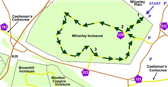
(Only designated cycle tracks are usually mentioned below and shown on the map (as yellow lines), not footpaths and other tracks. Cycle route marker post numbers are also shown).
1) From the car park, enter Wilverley Inclosure and continue straight ahead until a ‘T’ junction is reached. Notice here the low, metal plate opposite, by the ride-side – it provides details of enclosure dates.
2) Turn right and follow the track for just over 1 kilometre (0.6 miles). Bear sharp left just before the A35 is reached, and continue on for another 0.75 kilometres (1/2 mile).
3) Turn left uphill at a ‘Y’ junction, and follow the track round until a ‘T’ junction is reached. Turn left here and then almost immediately right, to return to the car park.
More links
Search this site

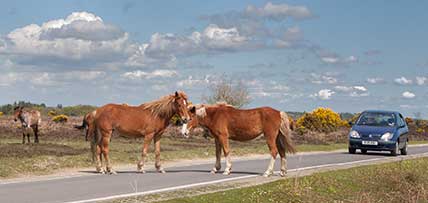
Sadly, 58 animals were killed - 35 ponies, 13 cows, 8 donkeys and 2 sheep, whilst a further 32 were injured - 3 pigs, 9 donkeys, 11 cows and 9 ponies.
(Forty-three accidents occurred in daylight, 15 at twilight and 101 in the dark. Twenty-seven accidents were not reported by the driver involved).
Here's just one horrific example - Three donkeys killed in collision with van at notorious New Forest blackspot (Advertiser and Times)

