

New Forest Cycling
Cycle ride 6
Woodland near Fritham, including King’s Garn Gutter Inclosure, Salisbury Trench and Coppice of Linwood
Start: Stoney Cross Plain car park, close to Longbeech camp site (SU 247126).
Station: Ashurst, 13 kilometres (8 miles).
Camping in the Forest campsites: Longbeech is at the start of the route; Ocknell is 1.5 kilometres (1 mile) away.
Alternative starts: Janesmoor Pond car park and the cycle route access point from the minor road north-west of Salisbury Trench and Coppice of Linwood (route marker 20).
Distance: 6.5 kilometres (4 miles), including a short stretch of road and a quite lengthy uphill section.
Shorten the route: To optionally reduce the distance covered (and avoid the quite lengthy uphill section), go left at the end of section 3 (cycle route marker number 26) to cycle around just one loop of the figure-of-eight circuit.
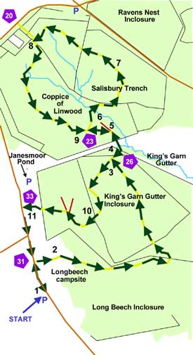
Enjoy a figure-of-eight circuit around woodlands in the north of the New Forest, not too far from Junction 1 of the M27 and even closer to Longbeech and Ocknell camp sites. And whilst of only fairly modest distance - 6.5 kilometres (4 miles) - this cycle ride does provide an element of quite vigorous exercise during a relatively prolonged uphill section.
The ride starts in the Stoney Cross Plain car park, which in days gone by formed part of the World War Two, Stoney Cross Airfield - there is an interpretation board on the edge of the car park providing lots of fascinating information about the airfield and its role in wartime Britain. In essence, it was opened in November 1942 and its use included as a base for parachute and glider towing training, and later for fighter and bomber planes. Flying from the airfield ceased in 1946, but it was not until 1956 that the land was returned to the Forestry Commission. Part of the old runways and taxi-ways are now used as public roads, whilst some of the narrow concrete roads within Longbeech campsite were once used by aircraft moving to still-visible dispersal pans, places around the perimeter of the airfield set aside for standing aircraft. (Dispersal pans continue to be visible in Ocknell campsite, too).
Initially following a short section of minor of road, the route soon takes to the woods as it passes through Longbeech camp site before reaching King's Garn Gutter Inclosure, a block of primarily coniferous woodland first set aside for forestry use in 1860 - a 'gutter' in the New Forest is a small stream, although we're left to wonder about the origin of the word 'garn'. Coppice of Linwood, first enclosed in 1768, comes next and features many fine, aged broadleaved trees amidst scatterings of conifers, followed by Salisbury Trench, a very early inclosure dating back to 1700, although many of the trees here are much younger.
Wildlife may be encountered anywhere along the way, including fallow deer which are most likely to be seen early and late in the day.
The route
(Only designated cycle tracks are usually mentioned below and shown on the map (as yellow lines), not footpaths and other tracks. Cycle route marker post numbers are also shown).
1) Turn left along the road out of the car park, and after a short distance, turn right towards Longbeech camp site.
2) Continue along the camp site road, pass through the site, and after 1 kilometre (0.6 mile), at the end of the road, follow the track as it goes sharply left into King’s Garn Gutter Inclosure.
3) After 1 kilometre, reach a ‘T’ junction.
5) Almost immediately, miss a turn on the right – not a cycle track – and then shortly after, turn right at the next ‘T’ junction – cycle track sign number 23.
6) Cross a couple of small streams on this uphill stretch, and enter the conifers of Salisbury Trench.
7) Continue on, mostly uphill, for just over 1 kilometre and reach a 'T’ junction.
8) Turn left, downhill, back into Coppice of Linwood.
9) Eventually arrive back at the ‘T’ junction from 5 above, and continue straight on. Go back through the gate, over the open ground and straight on again at the next ‘T’ junction.
10) After just over 0.5 kilometres (1/3 mile), pass through a gate and an area of substantially thinned, open coniferous woodland. At the next junction, pass two tracks on the right – not cycle tracks, pass through another gate and reach the public road.
11) Turn left and the car park is 0.75 kilometres (1/2 mile) away.
Quick linksMore links
Search this site
Sadly, 58 animals were killed - 35 ponies, 13 cows, 8 donkeys and 2 sheep, whilst a further 32 were injured - 3 pigs, 9 donkeys, 11 cows and 9 ponies.
(Forty-three accidents occurred in daylight, 15 at twilight and 101 in the dark. Twenty-seven accidents were not reported by the driver involved).
Here's just one horrific example - Three donkeys killed in collision with van at notorious New Forest blackspot (Advertiser and Times)