New Forest Cycling
Cycle ride 4
Woodland and heathland between Brockenhurst and Beaulieu, including Beaulieu Heath and Frame Heath Inclosure
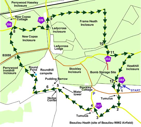
Start: The Hawkhill car park just over 0.5 kilometre (0.3 mile) east of Stockley Cottage on the B3055 Brockenhurst to Beaulieu Road (SU 351018) - on the opposite side of the road to Stockley Cottage and Roundhill camp site.
Station: Brockenhurst, 6 kilometres.
Camping in the Forest campsites: Roundhill, 2.5 kilometres (1 1/2 miles); Hollands Wood, 6 kilometres.
Alternative starts:
Stockley car park, adjacent to Stockley cottage; or Roundhill campsite; or for those cycling from Brockenhurst, the route can also be joined where it crosses the B3055 to enter New Copse Inclosure at section 7 of the cycle route.
Distance: 9 kilometres (5 1/2 miles), all off road.
Extend or shorten the route: To optionally increase the distance covered, combine this cycle ride with nearby Cycle ride 3 (to the north-west of this ride). Alternatively, to reduce the distance covered, take any of the cycle route shortcuts shown in yellow on the map.

Experience a slice of military history and a raft of hugely varied landscapes during this cycle ride in the south of the New Forest - the route crosses part of the World War Two, Beaulieu airfield, now mostly returned to heathland, and continues through extensive woodlands.
The ride starts in the Hawkhill car park on the B3055 Brockenhurst to Beaulieu Road, whilst Roundhill campsite, passed along the way, provides a good alternative start, particularly for those staying on the campsite.
Heathland occupies the early part of the route, until a fragment of open woodland is encountered on the edge of Roundhill campsite before entering Perrywood Ironshill Inclosure, which was first set aside for trees in 1866, and is now primarily coniferous, with only a small number of broad-leaves. Across the B3055, New Copse Inclosure is next in sequence. First enclosed in 1808, it contains some conifers, but also features a great many mature oak and beech trees, including a small number that probably pre-date enclosure. Then, after passing along an attractive drift-way bordered by ancient, unenclosed woodland, comes Frame Heath Inclosure, first enclosed in 1852 and comprising mixed woodland with conifer blocks of modest size, and a considerable number of mature broad-leaves, primarily oaks. And finally there is Hawkhill Inclosure, woodland that was first enclosed in 1870, and even now is primarily coniferous.
The early, concreted part of the route on the heath follows the old Beaulieu Airfield taxiways and service roads, whilst nearby, the outline of the airfield runways is still clearly visible. Beyond the Hawkhill Inclosure car park - back in the woods - the remains of a contemporary bomb storage site is passed; and bumps, hollows, concrete building bases and, part-hidden amongst trees, an old water tower are the remains of accommodation facilities used by airfield personnel.
Bronze Age barrows are something of a feature of this cycle ride: one, shown as a Tumulus, is close to the road by Hawkhill car park; another is by the track further along on the heath; and a third, marked on the Ordnance Survey map as Pudding Barrow, is on the edge of Roundhill camp site.
Sika deer are present hereabouts in reasonable numbers, particularly within Frame Heath Inclosure, but also in the other woods passed along the way, and occasionally on the heathland. Views of these charming, sometimes confiding creatures, first introduced from Asia onto the Beaulieu Estate at the turn of the 19th / 20th centuries, best await those passing quietly through, although more boisterous cyclists may also glimpse the animals crossing the cycle track, wandering through the woods or simply standing amongst the trees, waiting for intruders to pass by.
Woodland birds, almost needless to say, are likely to be present in good numbers, whilst on the heath there is always a chance of seeing or hearing an often elusive Dartford warbler and usually more conspicuous stonechats and linnets.
The route
(Only designated cycle tracks are usually mentioned below and shown on the map (as yellow lines), not footpaths and other tracks. Cycle route marker post numbers are also shown).

1) Leave the car park, cross the minor road (B3055) – the first Bronze Age barrow is to the right here - and continue south along the cycle track, which is actually an old, airfield service road. Notice here also distant views across the heath to the hump-backed hills of the Isle of Wight.
2) Reach a ‘T’ junction and turn right along a long-since disused, airfield taxiway.
3) Follow the cycle track as it eventually swings round to the right where the concrete gives way for a short distance to compacted gravel. Notice here to the left, the rounded hillock of a second Bronze Age barrow, opposite a quite large, concrete rectangular area – a World War Two hangar was here; this is probably its site.
4) And then shortly after, turn left at another ‘T’ junction. Almost immediately, ignore a turning on the left (it is not a cycle track) and continue along the concrete track – this was the service road that linked the airfield with staff living quarters in the area around what is now Roundhill camp site - to reach Hedge Corner and the edge of the camp site.
5) Notice to the right, half hidden amongst a group of conifers, the disused Second World War water tower, whilst straight ahead can be seen an eroded, fenced Bronze Age barrow – the name, Pudding Barrow’, presumably refers to its shape.
6) Follow along the narrow tarmac road with farmland on the left, and Roundhill camp site on the right. After 0.5 kilometres (1/3 mile), follow the track as it goes sharp right, then after another 0.5 kilometres swings left past Round Pond to join the road out of the camp site, through Perrywood Ironshill Inclosure.
7) Cross a minor road – it’s the B3055 again – and enter New Copse Inclosure, following the sign for New Copse Cottage.
8) After 0.75 kilometres (1/2 mile), reach a crossroads and turn right, then after 1 kilometre (0.6 miles), leave New Copse Inclosure and turn left at a ‘T’ junction to travel along the drift-way between New Copse and Frame Heath Inclosures.
9) After a short distance, at another ‘T’ junction, turn right into Frame Heath Inclosure; then after 1.5 kilometers (1 mile), follow the cycle track as it turns right.
10) After another 0.75 kilometers, go through a gate out of Frame Heath Inclosure, cross the narrow drift-way between Frame Heath and Hawkhill Inclosures, and enter Hawkhill Inclosure at another gate.
11) After a short distance, turn left at a ‘X’ roads – cycle track sign number 332. Note, though, that the way straight ahead is not a cycle track. After 0.5 kilometres, take the next right turn at a ‘T’ junction.
12) Reach the gate out of Hawkhill Inclosure, and the car park is to the left. (In Hawkhill Inclosure, by the trackside not far from the exit gate, can be seen old, low walls, and the outline of building foundations. A Second World War, Beaulieu Airfield bomb storage site was located here – maybe these remains date back to that time).
More links
Search this site

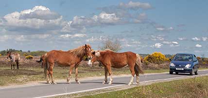
Sadly, 58 animals were killed - 35 ponies, 13 cows, 8 donkeys and 2 sheep, whilst a further 32 were injured - 3 pigs, 9 donkeys, 11 cows and 9 ponies.
(Forty-three accidents occurred in daylight, 15 at twilight and 101 in the dark. Twenty-seven accidents were not reported by the driver involved).
Here's just one horrific example - Three donkeys killed in collision with van at notorious New Forest blackspot (Advertiser and Times)

