New Forest Cycling
Cycle ride 2
Woodland near Ashurst, including Busketts Lawn, Lodgehill and Ironshill Inclosures
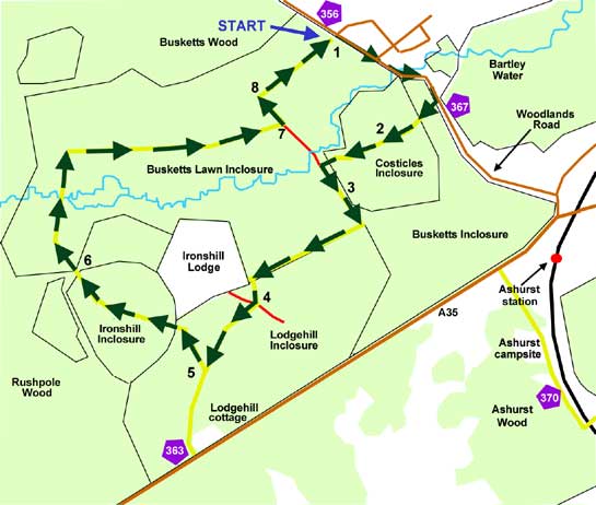
Start: Park beside Woodlands Road, 1.5 kilometres (1 mile) north-west of Ashurst station, by a telephone box, and gate leading into Busketts Lawn Inclosure - SU 324111 (cycle track sign number 356). Note, parking is somewhat limited here – enough only for 4-5 cars.
Station: Ashurst, 1 kilometre (0.6 miles).
Camping in the Forest campsite: Ashurst, 1.5 kilometres.
Alternative starts: There is another gate with even more limited parking – enough for 2-3 cars - a little closer to Ashurst, on Woodlands Road: by cycle track sign number 367. Alternatively, try the Busketts Lawn car park – continue along Woodlands Road, turn left at the first T junction, and the car park is a short distance away, on the left. Those cycling from Lyndhurst can join the route close to Lodgehill Cottage, on the A35 Lyndhurst to Ashurst road - cycle track sign number 363.
Distance: 5.5 kilometres (3 1/2 miles), including a short stretch of Woodlands Road.
Extend the route: To optionally increase the distance covered, combine this cycle ride with nearby Cycle ride 1 (to the south-east of this ride).

The extensive woodlands to the south-west of Ashurst, close to the New Forest boundary in the north-east of the area, provide a pleasant cycle ride of moderate distance that is particularly suitable for families and those seeking a little exercise, enjoyment and fresh air. Ashurst campsite, Ashurst railway station and the New Forest inn are all close by, whilst level ground with no hills of any substance is an attractive feature of the route.
The ride starts in Woodlands Road, Ashurst - the road heading north-west from the Lyndhurst end of the bridge over the railway line.
Wild flowers, woodland birds and butterflies are, in season, all likely to be present. Indeed, some of the tracks were specially widened in the late 1990s to encourage bramble, thistle and other wild flower growth, which in turn encourages the presence of a wide range of insects.
Fallow deer and roe deer might also be spotted by fortunate passers-by, particularly those quietly out and about early and late in the day, whilst in spring and summer, detours on foot alongside Bartley Water - a beautiful, steep banked New Forest stream encountered along the way - will often yield a range of dragonflies and damselflies, and a variety of waterside birds including ever-elusive kingfishers and occasional little egrets.
The route first passes through the small, somewhat oddly named Costicles Inclosure, an inclosure that contains some conifers but also features considerable amounts of attractive oak and beech trees, many dating back to creation of the inclosure in 1829. (Prior to that date, and on the same boundaries, old maps show Costicles Wood, which it seems reasonable to assume was a delightful old woodland of similar structure to today's ancient, unenclosed woodlands).
Lodgehill Inclosure dates back to 1810 and features much coniferous woodland with some areas of oak and beech, whilst Busketts Lawn Inclosure was created in 1864 and is now an attractive mixture of broadleaved trees and conifers that include, along Bartley Water and the side of some of rides, numerous impressive examples of Douglas fir.
Ironshill Inclosure - another small inclosure within the much larger block of woodland - was created in 1810, although from the mid-18th century it was the site of a master keeper's lodge that was subsequently used first as a royal residence and later as a prison during the Napoleonic Wars before eventual demolition. Today's Ironshill Lodge was the site of an underkeeper's, or groom keeper's, lodge constructed in 1609, rebuilt in the late 18th century and since much enhanced. Oak and beech are conspicuously present and so is hazel which, combined with the semi-circular shape of the inclosure, has led to suggestions that an even older coppice once occupied the site.
The route
(Only designated cycle tracks are usually mentioned below and shown on the map (as yellow lines), not footpaths and other tracks. Cycle route marker post numbers are also shown).
1) Leave the parking area by the telephone box, turn right along Woodlands Road, turn right again at a gate, and continue along the cycle track through Costicles Inclosure.
2) Follow the cycle track for 0.5 kilometres (1/3 mile), to leave Costicles Inclosure just before a 'T' junction is reached – the cycle track goes left here.
4) Almost immediately after, go straight across at a X-roads – the intersecting track is well-made and compacted, but is not a cycle track.
5) After a further 0.3 kilometres (1/5 mile), turn sharp right at a 'T' junction and continue to follow the track through Lodgehill Inclosure, and then Ironshill Inclosure.
6) Enter Busketts Lawn Inclosure, cross Bartley Water, and follow the cycle track to the right, on through Busketts Lawn Inclosure.
7) After a further 1 kilometre, reach a 'T' junction, and turn left. (Again, although well-made and compacted, the turn to the right is not a cycle track).
8) After a short distance, follow the cycle track to the right, and return to the Woodlands Road ‘telephone box’ car parking area.
More links
Search this site

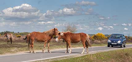
Sadly, 58 animals were killed - 35 ponies, 13 cows, 8 donkeys and 2 sheep, whilst a further 32 were injured - 3 pigs, 9 donkeys, 11 cows and 9 ponies.
(Forty-three accidents occurred in daylight, 15 at twilight and 101 in the dark. Twenty-seven accidents were not reported by the driver involved).
Here's just one horrific example - Three donkeys killed in collision with van at notorious New Forest blackspot (Advertiser and Times)

