

New Forest Cycling
Cycle ride 10
Woodland, heathland and farmland near Linwood
Start: Milkham car park at the north-east edge of Milkham Inclosure (SU 217103).
Station: Ashurst, 16 kilometres (10 miles).
Camping in the Forest campsites:
Longbeech, 6 kilometres (3 3/4 miles);
Ocknell, 7 kilometres (4 1/4 miles).
Alternative starts: Car parks north and north-west of Milkham Inclosure - High Corner (SU199104) and Spring Bushes (SU202102).
Distance: 10 kilometres (6 1/4 miles), including two stretches of relatively quiet roads.
Extend or shorten the route: To optionally increase the distance covered, continue straight ahead at cycle route marker number 41 and then follow the track to the right at marker number 36; or join the main cycle route network at marker number 61 or 63. Alternatively, to reduce the distance covered, turn right at marker number 46 and follow the road back to the start point.
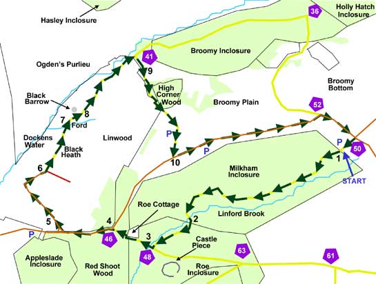
Providing a pleasant foray in the area around Linwood, this 10 kilometre (6 1/4 mile) cycle ride passes through a variety of woodland landscapes, crosses open heath and farmland, and in places follows relatively quiet roads. It starts in the Milkham car park, at the north-east edge of Milkham Inclosure, although alternative starts are available from two further car parks: Spring Bushes, adjacent to the northern edge of Milkham Inclosure, and the High Corner car park a little farther to the north-west.
Refreshment stops are available beside the route at the Red Shoot Inn and the High Corner Inn.
Woodland birds that might be seen include great spotted woodpecker, nuthatch and crossbill, whilst the heathlands and valley-bottom wetlands found on Broomy Plain and Ocknell Plain (a little farther to the east) are often hunted over by autumn and winter hen harriers and occasional great grey shrikes. Deer, particularly fallow deer and sometimes roe deer, may be encountered just about anywhere along the route, but are more likely to be seen in quieter places away from the roads.
Milkham Inclosure is one of the later forestry inclosures - the land was set aside for trees in 1861 under provisions made in the 1851 Deer Removal Act - and from the car park presents a perhaps foreboding, coniferous appearance. There are, however, some nice stands of oak later on beside the route.
Milkham eventually gives way to Roe Inclosure, a particularly attractive, mixed broad-leaved and coniferous woodland with a long history: trees were first planted in the southern part of the site in around 1700 in what was to become known as Roe Old Inclosure; but in 1811, the earlier planting was subsumed within the fences of a new, considerably extended inclosure.
Evidence of human activity does, though, date back thousands of years for within the inclosure, not far from our cycle route, hidden deep amongst the trees, is Castle Piece, a broadly circular enclosure of around 2 hectares (almost 5 acres) surrounded by a large, flattened earthen bank with, in places, an adjacent external ditch, the whole considered to be of Iron Age origin.
Ancient, unenclosed woodlands - woodlands open to deer and commoners' stock - are well-represented along the way, in Red Shoot Wood and High Corner Wood, whilst the Linford Brook and Dockens Water provide yet more scenic variety.
Good views can also be enjoyed over the open heathlands and wetter areas of Ogden's Purlieu. (A purlieu is an area of land once removed from New Forest jurisdiction, although Ogden's Purlieu is now again within the bounds of the Forest. Ogden Rooke in the second half of the 17th century was apparently associated with this land, hence the name).
The route
(Only designated cycle tracks are usually mentioned below and shown on the map (as yellow lines), not footpaths and other tracks. Cycle route marker post numbers are also shown).
1) Enter Milkham Inclosure and cycle mostly downhill for 2 kilometres (1 1/4 miles). Notice along here on the right, south-facing side of the track, numerous enormous, conically shaped Southern Wood Ant nests.
2) Cross a bridge over the Linford Brook, and enter Roe Inclosure before, after a further 0.5 kilometres (1/3 mile), turning right at the first ‘T’ junction – cycle track sign number 48.
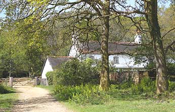
3) Almost immediately re-cross the brook at another bridge, continue uphill past Roe Cottage and into the ancient, unenclosed woodlands of Red Shoot Wood – notice along here two magnificent, aged pollard oaks, one on either side of the track.
4) Reach a minor road, and turn left, downhill, before, after a further 0.5 kilometres, turning right into a narrow lane beside The Red Shoot Inn.
5) Pass a ‘No through road’ sign, and at the bottom of the hill, cross a ford and follow the lane round as it turns sharply right – there are numerous old, coppiced hazels along here, evidence of a country craft largely now obsolete.
6) Leave the tarmac road and continue straight on, along a somewhat rutted track, then after a short distance, ignore a non-cycle track turn to the right, and follow the cycle track straight ahead, over the open expanse of Black Heath, with away to the left, the higher ground of Ogden’s Purlieu.
7) After just over 0.5 kilometres, cross a ford over a narrow stream and follow the cycle track as it goes to the right.
8) Pass Black Barrow – this seems to be a natural hillock rather than a Bronze Age Barrow – and after another 1 kilometre (0.6 miles), pass close to Dockens Water before, at a ‘T’ junction, following the track to the right, uphill.
9) Follow the grassland edge before continuing on uphill, through the ancient, unenclosed woodlands of High Corner Wood, past the High Corner Inn and across a corner of Broomy Plain.
10) Reach a minor road and turn left. After 1.5 kilometres (1 mile), follow the road to the right – ignore the cycle track on the left - and then after a further 0.5 kilometre, turn right along the cycle track to return to the car park.
More links
Search this site
Sadly, 58 animals were killed - 35 ponies, 13 cows, 8 donkeys and 2 sheep, whilst a further 32 were injured - 3 pigs, 9 donkeys, 11 cows and 9 ponies.
(Forty-three accidents occurred in daylight, 15 at twilight and 101 in the dark. Twenty-seven accidents were not reported by the driver involved).
Here's just one horrific example - Three donkeys killed in collision with van at notorious New Forest blackspot (Advertiser and Times)