

New Forest Walks - Millyford Bridge and Acres Down
This walk starts beside Highland Water, passes through Holmhill Inclosure and the beautiful ancient woodlands of Wick Wood, before crossing attractive heathland at Acres Down and returning through the woods around Broom Hill.
Overview
Steep-banked Highland Water, flowing over gravel beds, graces the start of this walk. Evidence of man’s past attempts to speed the flow is visible along the way, but the changes, mostly made many years ago, have been absorbed into the landscape as nature has reclaimed its own. Here, kingfishers and grey wagtails can sometimes be seen and from the end of May until August, Beautiful Demoiselle damselflies, too.
Inclosure woodland is quickly reached in the form of Holmhill Inclosure. First set aside to grow trees in 1670, the original inclosure was largely taken into a later inclosure of the same name created in 1815. Few trees from the original inclosure remain, although the related, substantial surrounding earthen wood-bank is in many places still evident.
Holmhill Inclosure features many fine, mature broad-leaved trees such as oak and beech tree, as well as a variety of conifers, including by the ride-side, a stand of larch that in winter attracts mixed flocks of finches to feed – look out for siskins, redpolls and goldfinches in loose, twittering flocks. Notice also along here the prominent nests of southern wood ants, built into typical conical shape in clearings or beside the path where warming sunlight is most likely to fall.
Ancient, unenclosed woodlands are well-represented along the way - at the start of the walk, and by Wick Wood and the areas around Broom Hill and Wood Crates. Here, relatively free from recent human interference, nature is allowed to take its course.
Trees are left to live their natural span, and to then decay and fall. Timber debris litters the woodland floor, whilst deer and commoners’ stock freely wander, avidly grazing and browsing, contributing significantly to the unique character of these places.
Fallow deer and roe deer are likely to be present in the woods (and on the heath), whilst a range of woodland wild flowers, birds, butterflies and fungi will often add further wildlife interest to the walk.
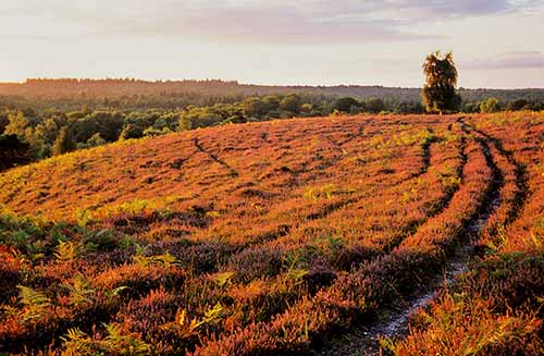
Mid-way along the route, the high ground at Acres Down offers magnificent views westwards across a sea of trees, and is a popular spot with birdwatchers looking for birds of prey soaring on the thermals.
To the south, the landscape falls away towards The Solent, and on clear days, in the distance can be seen the hump-backed ridge of the Isle of Wight and Peterson’s Folly, or Sway Tower as it is more often known. Built in the late-19th century and standing at 218 feet high, the tower was constructed by Judge Andrew Thomas Turton Peterson, who set out to demonstrate use of un-reinforced concrete.
The heathland at Acres Down and Pilmore Gate Heath is inhabited by Dartford warblers, stonechats and, in spring and summer, nightjars and the occasional hobby. Lizards scurry across the heather tops, whilst at the first hint of danger, adders move away unnoticed.
And in the wetter places, sundews and butterworts patiently await the arrival of insect prey.
6.5 kilometres (4 miles).
Start:
Millyford Bridge car park – 4 kilometres (2½ miles) west of Lyndhurst village centre.
Terrain:
Mainly on level ground, but with a small number of short, quite steep gradients; and mostly firm, but as sections can at times be wet and muddy, strong boots are recommended.
Refreshments:
Whilst not on the walk route, the New Forest Inn at Emery Down is a relatively short distance away - around 600 metres from the start of section 9 of the walk route, and around 2 kilometres from the Millyford Bridge car park.
New Forest Tour bus route:
No.
Parking
Parking is available in the Millyford Bridge car park – 4 kilometres (2½ miles) west of Lyndhurst village centre.
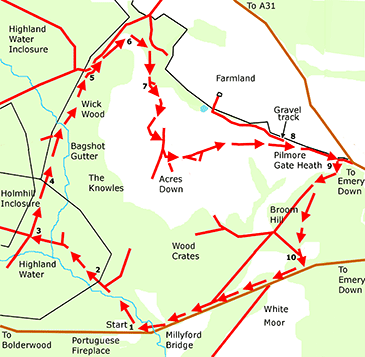
Walk route directions
1. Leave the car park at Millyford Bridge along a gravel track leading directly away from the road. Cross a bridge over a narrow side-stream, and then cross another over the main river. Notice here on both sides of the path the often water-filled meander cut off from the main flow.
Pass on the left a number of magnificent, centuries old beech trees, and equally aged hollies; cross a small clearing and go through a gate into Holmhill Inclosure.
2. Continue along the gravel track; pass over a crossroads where a grassy ride intersects the gravel track, and cross a small bridge over a tiny stream - Bagshot Gutter.
3. At the next crossroads, turn right down a grassy ride bordered on either side by re-generating conifers and birch scrub. Notice on the left at the crossroads the area of regenerating woodland fenced to keep out commoners’ stock, and deer.
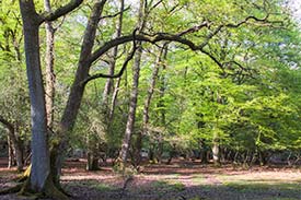
4. Go through the gate into the ancient, unenclosed woodland of Wick Wood. Continue straight on along the path below spreading branches of giant oak and beech pollards. Freshly pollarded hollies, too, are present, evidence of recent attempts to encourage habitat diversity.
Meet a track coming in from the left, and here turn right to cross a small bridge over an equally small stream – this again is Bagshot Gutter. Damp alder carr borders the stream, interspersed with willow and occasional birch.
Cross a small clearing somewhat overgrown with birch and immature oak, and follow the track as it bends left through a grove of invading birch - ignore the grassy ride that goes straight on.
Continue on until a gravel track is reached in a small clearing.
5. Turn right immediately before the gravel track, following a path uphill through mature trees and smaller, but equally aged, hollies. Follow the path as it bends right, with away to the left the Acres Down car park. Eventually emerge onto the bracken-clad summit above the car park, and continue across the edge of the rim with the valley deep below to the right.
6. At the far side of the plateau, turn right downhill along a pronounced gravel track that skirts the lower slope of the valley side. To the right in the valley bottom is an area of bog, complete with quaking sphagnum moss and patches of standing water.
Continue on along the path, eventually passing through a grove of invading birch and mature, broad-crowned Scots pine trees.
7. Please note, many of the paths and tracks referred to during this section are not particularly clear, especially from late spring until autumn when vegetation in places obscures the way. If in doubt, maintain a course that will lead to the gravel track adjacent to the farmland away to the left - ready for the start of Section 8.
Take the next right hand fork in the track, and almost immediately follow the track to the left, uphill around the valley side. Follow the path again to the left as another hill-top plateau is reached. At a ‘T’ junction, turn right and then almost immediately take the left fork at a ‘Y’ junction. Almost immediately again, take another left fork.
(It is from here that the Isle of Wight can best be seen, whilst when looking almost due south, the narrow column of Sway Tower is similarly visible).
Continue on through an expanse of mature gorse; stunted, heavily browsed hollies; and invading birch. Look and listen particularly along here for the nervous chakk-chakk-chakk alarm calls of stonechats, and the harsh, buzzing churr of Dartford warblers.
Reach a ‘Y’ junction, and take the left hand fork to pass through an area of mature gorse. Meet another track coming in from the right, and go left to skirt a clump of gorse, birch and holly.
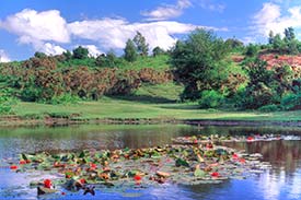
(To the left, downhill, is a small pond nestling in the valley bottom. In late spring and summer, it is brightened with attractive expanses of red and white flowering lilies; tall, erect stems of yellow iris; and numerous species of dragonflies and damselflies. It is also a magnet for New Forest ponies and cattle, anxious in the heat of the day to quench their thirst.
Beyond, agricultural land stretches away into the distance, whilst straight ahead, somewhat incongruous on the horizon, can be seen the high-rise blocks of Southampton’s suburbs).
Follow the track downhill.
8. Turn right along the next gravelled track. Pass farm buildings on the left, then a cottage, and eventually, the entrance drive to a property called Crownwood.
9. Reach another property on the left, opposite an area of grassland.
For those who wish to make a refreshment stop at the New Forest Inn, continue straight ahead here, and again go straight ahead at a nearby minor road, heading for Emery Down. The New Forest Inn is around 600 metres away.
Otherwise, turn sharp right immediately, and follow the grassland edge down into the bottom corner, ignoring two tracks to the right leading through to heathland. Follow this path into the wood.
After a short distance, cross a small, grassy clearing, and follow the path as it eventually bends left. Continue on uphill until a ‘T’ junction of paths is reached. Here, turn left, heading downhill to another area of grassland visible through the trees.
10. Reach the grassland and continue across to the minor road leading to Millyford Bridge – if it is particularly wet, to avoid a damp channel that runs down the shallow valley bottom here, go slightly left immediately upon leaving the wood, and then turn right to regain the original course.
Reach the road and turn right to walk back to the car park.
Quick links
More links
Search this site