

New Forest Short Walks - Walks from Lyndhurst
This walk crosses Lyndhurst’s old Race Ground and skirts the Golf Course.
Overview
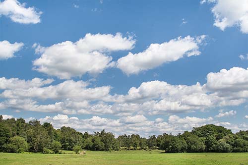
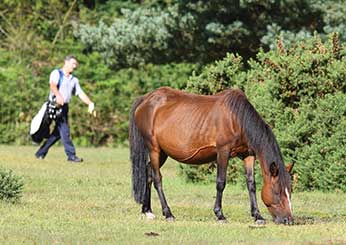
After leaving the village centre, this walk crosses an extensive area of grassland that is a magnet for commoners’ ponies and cattle. Until around 1880 it was the site of Lyndhurst race ground. Indeed, the adjacent road is still called Racecourse View. And from 1922 until after the Second World War, the New Forest pony sales and accompanying fair were held here.
Beyond the race ground, the route skirts a golf course, which was opened in 1890 on part of the race ground, and then passes alongside a narrow band of alder carr.
Woodland birds can be relied upon to brighten the walk. Listen for the year-round ringing calls of nuthatches as these dapper creatures clamber up trunks and boughs. Great spotted and green woodpeckers are also prominently present, whilst tiny lesser spotted woodpeckers tend to be far less conspicuous.
Siskins breed locally, and they and occasional flocks of winter redpolls can sometimes be seen and heard feeding amongst river-side alders. Buzzards, meanwhile, soar high above the grasslands, find vantage points on which to perch or, in wet weather, stalk the grasslands in search of worms.
Fallow deer and roe deer emerge at dusk to feed on the edge of the golf course, and foxes can sometimes be seen, too, particularly in spring when hungry cubs encourage parents to hunt through much of the day.
4 kilometres (2½ miles).
Start:
Lyndhurst village centre, or the roadside lay-by opposite what used to be the Magistrates Court and Police Station.
Terrain:
Level ground and mostly firm, but as sections can at times be wet and muddy, strong boots are recommended.
Refreshments:
Pubs in Lyndhurst include The Fox and Hounds, The Stag, The Mailmans Arms and The Waterloo Arms. The Crown Hotel, too, serves food and drinks, and there are also numerous tearooms, cafes and restaurants.
New Forest Tour bus route:
Yes - summer only.
Parking
There is a large 'Pay and Display' car park in the centre of Lyndhurst. Alternatively, roadside parking is available in a lay-by opposite what used to be the Magistrates Court and Police Station.
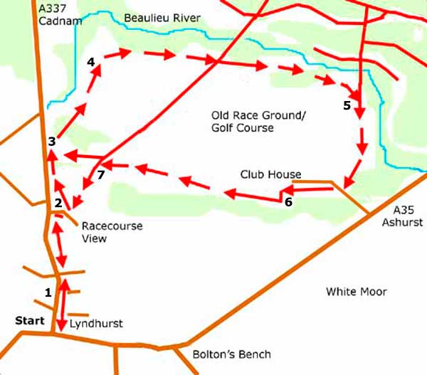
Walk route directions
1. Leave the village centre along Romsey Road – this is the road that enters the village at the traffic lights situated towards the top of the High Street.
Pass King’s Close on the left and a thatched cottage, also on the left – this was once the site of a turnpike toll gate used by the Salisbury, Landford, Ower and Eling Turnpike Trust.
Pass on the left a road immediately beyond the thatched cottage – Forest Gardens - then Gales Green, and eventually a black and white building called Turnpike Cottage – the site of another turnpike toll gate.
(Opposite, just beyond the last houses, can be seen the extensive grasslands of Lyndhurst’s old race ground).
Access to the race ground grassland is through a gate a short distance along Racecourse View, which is the road on the right beside the Forest Point Hotel.
Alternative access is available at the far end of the roadside lay-by opposite what used to be the Magistrates Court and Police Station.
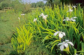
2. From the Racecourse View gate, go half-left to meet at the end of a drainage channel mid-way over the grassland, the fence bordering the main road. Look out here in May for magnificent displays of yellow iris in the channel, including many white-flowered examples.
A path running alongside the fence leads to the lay-by entrance.
3. From there, walk over the grassland towards a narrow gap in the trees, almost mid-way between the main road and a birch-clad hillock at the base of which is a bench.
Pass through the gap in the trees and skirt the golf course – here, amongst the short grass, can be found patches of heather, cross-leaved heath, tormentil and bog myrtle that betray the open-Forest origins of the course.
4. Reach a strip of primarily alder woodland that has grown up beside a narrow stream, the Beaulieu River whose source is just across the main road, not far from the police station. Turn right to follow the woodland edge.
(Many of the alders here show evidence of past coppicing and pollarding, a reminder that alder timber was a valuable resource that was often burnt to produce charcoal for use in the manufacture of gas mask filters).
After a relatively short distance, pass a turning on the left along a gravel track leading into the trees. Immediately after this track, pass a golf course green adjacent to a magnificent clump of ancient, coppiced hollies, with just beyond, an area of heath and rough grassland.
Continue along the edge of the golf course, and pass another turning on the left.
5. Follow the boundary of the course as it swings round to the right, cross the approach road and continue round as far as the clubhouse.
6. Reach the far end of the clubhouse car park, turn left and enter the adjacent straggle of woodland.
(Here can be found two parallel earthen banks 15 metres (50 feet), or so, apart, running almost from the A35 Ashurst road to the A337 Cadnam road. It’s tempting to imagine that these once bordered the race course, but sad to say, they're simply spoil heaps thrown up many years ago when the adjacent, now entirely natural-looking, drainage channels were dug out).
Turn right and proceed straight ahead between the two banks until a ‘T’ junction of tracks is reached.
7. To return to Racecourse View, turn left, cross an almost adjacent small bridge, and the gate alongside the road will be in sight across the grassland.
To reach the roadside lay-by, turn right at the ‘T’ junction of tracks, and then immediately left to follow woodland edge for a short distance, before crossing the grassland close to the road.
Quick links
More links
Search this site