

New Forest Short Walks - Walks from Lyndhurst
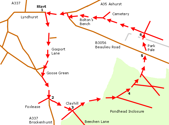
This walk passes through Pondhead Inclosure, and returns to Lyndhurst along the heathland ridge close to Bolton's Bench.
Overview
Beechen Lane was clearly shown on Isaac Taylor's 1759 map of the New Forest. It was then probably used as the main route through to Denny Lodge. Indeed, some have suggested medieval origins and use by the Cistercian monks of Beaulieu.
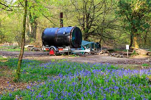
Previously known as Mine House Grounds, Pondhead Inclosure was first planted in 1810, and many of the original trees remain. Primarily a broad-leaved inclosure, Pondhead is surrounded by stock-proof and deer-proof fencing that for more than 30 years has helped reduce grazing and browsing pressure, allowing the growth of abundant wild flowers that attract large numbers of butterflies and other insects.
Rotational hazel coppicing has for many years also been undertaken, further encouraging the growth of wild flowers including magnificent displays of bluebells. The cut wood is burned to produce charcoal - proceeds from the sale of the charcoal contribute towards the cost of the coppicing and other conservation-related work.
Buzzards frequently soar above the trees, mewing loudly; Hawfinches can occasionally be seen; and so too can all three woodpecker species and a wide range of other, more common woodland birds.
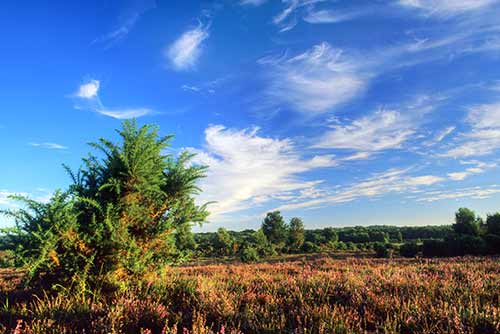
The Ridge on White Moor provides distant views across rolling New Forest heathlands and wetlands towards Longwater Lawn. The heathland here is home to a range of birds that in much of Britain are scarce or absent.
Look out for Dartford warblers, woodlarks and stonechats, and from May to early August, at dusk, listen for the churring calls of nightjars. Another national rarity, the silver-studded blue butterfly, is also abundant here during July and early August, which is the main flight period.
The narrow neck of the Park Pale can also be seen on The Ridge where it now survives as a somewhat wasted earthen bank and ditch. Dating back to at least the 13th century, the Park Pale once surrounded a medieval deer park known latterly as Lyndhurst Old Park.
3 kilometres (almost 2 miles).
Start:
Lyndhurst village centre.
Terrain:
Mainly on level ground, but with a single, gentle gradient; and mostly firm, but after heavy rain, short sections can be quite wet, and strong boots are then recommended.
Refreshments:
Pubs in Lyndhurst include The Fox and Hounds, The Stag, The Mailmans Arms and The Waterloo Arms. The Crown Hotel, too, serves food and drinks, and there are also numerous tearooms, cafes and restaurants.
New Forest Tour bus route:
Yes - summer only.
Parking
There is a large 'Pay and Display' car park in the centre of Lyndhurst.
Walk route directions
1. Leave the village centre and walk south along Gosport Lane until Goose Green is reached. Take the left fork towards Brockenhurst, and beside Foxlease Bridge, pass the site of the now-demolished turnpike cottage.
Turn left opposite the entrance to Foxlease, the Girlguiding UK Training and Activity Centre.
2. Pass immediately on the right the old thatched Glenber Cottage, and continue straight ahead along Beechen Lane until the woodlands at Clayhill are reached.
3. Immediately before the wide Forestry Commission vehicle gate across the gravel track leading straight ahead, turn left through a gate leading into Pondhead Inclosure. After just over 0.5 kilometres, a ‘Y’ junction is reached - follow the fork to the left.
4. After a short distance, pass on the right an area of actively managed hazel coppice, and on the left a relatively recently clear-felled area. Pass a grassy ride on the right leading between the hazels, and a little way further on, a more pronounced right turn
Cross a small bridge over a stream, leave the woodland through a narrow gate, and reach the Beaulieu Road, close to The Ravens, a property recalling in name that once-lost New Forest bird, and the appropriately named Ridge House.
5. Cross the road and follow a quite wide path running almost straight ahead up the gorse-clad hillside leading to The Ridge, on White Moor.
(Notice as the top of the hill is reached the path intersects the wasted bank and ditch of the Park Pale. Notice also, to the left, the tall spire of Lyndhurst Parish Church, and beyond, the white-washed walls of Northerwood House on the hill at Emery Down).
6. At the top of the hill, turn left to follow the path towards Bolton’s Bench, past the village’s late 19th century cemetery, and beyond, back to Lyndhurst High Street.
Quick links
More links
Search this site